Snow is falling in Colorado along with soaking rain

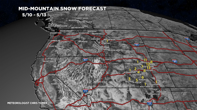
Tomer’s Take: Snow is falling above 10,000ft in Colorado while Denver gets soaking rain through 5/12. Large, widespread hail nailed Denver and the Front Range last night. That risk has now passed as the storm system has “cooled”.

I’m also watching a Monsoon-esque flow 5/14-5/15 as atmospheric wind turns southerly pulling up Gulf Moisture into NM and parts of CO.

View on top of the Divide at 12,700ft from Loveland Ski Area:

Forecast Freezing Level

Colorado’s Central Mountain Zone, Daily Max/Min:

5/11: 11100’/10000′

5/12: 12300’/10100′

5/13: 10800’/9800′

5/14: 11800’/10800′

5/15: 13800’/12000′

Forecast Wind Gusts

Quandary Peak, CO:

5/11: 40mph

5/12: 40mph

5/13: 20mph

5/14: 30mph

5/15: 20mph

Mount Superior, UT:

5/11: 20mph

5/12: 20mph

5/13: 25mph

5/14: 30mph

5/15: 15mph

Forecast Pattern

Forecast jet stream valid 5/14. Notice the large overall ridge with Northern Branch running through Canada. Weak southern branch from cut-off low turns wind southerly. This opens the door for Monsoon-esque flow Sunday 5/14-5/15. Rain moves into the NM and parts of CO.

Forecast jet stream valid 5/19. Mostly high pressure ridging with weak wind across the Intermountain West.

Monsoon-esque Flow 5/14-5/16

Forecast Timing

Forecast radar/satellite valid 5/11-5/16.

Heavy Rain

Flash flooding possible across Denver, Front Range, and Eastern Plains on 5/11 and early 5/12.

Forecast Totals

5/11-5/18.

A-Basin, CO Snow Timeline:

5/11: 4″

5/12: AM 2″

5/13: PM 3″

5/14: 1″

CO Severe Weather, Soaker, & Snow

Tomer’s Take: Golfball sized hail fell over parts of Colorado’s Front Range last night (Erie, Timnath, Firestone, Brighton, Lochbuie, Wiggins) and is likely again this afternoon plus a couple tornadoes. This is the first ‘Enhanced Severe Weather Risk’ for Denver since 2018. Then, the pattern “cools” with heavy rain and mountain snow likely. The bulk of snow occurs above 10,000ft.

Longmont, CO last night (5/9), from Gabe Cox:

Forecast Freezing Level

Colorado’s Central Mountain Zone, Daily Max/Min:

5/10: 13500’/10800′

5/11: 11200’/10000′

5/12: 12100’/10200′

5/13: 10700’/10000′

5/14: 11500’/10300′

Forecast Pattern

Forecast jet stream valid 5/11. Notice the closed off area of low pressure over Eastern Colorado. This equates to a slow moving storm system with heavy precipitation.

Severe Weather

The Storm Prediction Center has issued an ‘Enhanced Risk’ (orange color) of severe thunderstorms with large hail and tornadoes for the Front Range and Eastern Plains of Colorado effect 5/10. This is the first ‘Enhance Risk’ since 2018 in Denver. ‘Slight Risk’ for severe thunderstorms in yellow.

Timing: 2pm-6pm in Denver, Boulder, Loveland, Fort Collins.

The Colorado Climate Center and State Climatologist Dr. Russ Schumacher put this climatological severe weather graphic together for Colorado. Notice where the bulk of colors are = Front Range and Eastern Plains.

Excessive Rainfall Outlook valid 5/11:

Forecast Timing

Forecast radar/satellite valid 5/10-5/15.

Forecast Totals

5/10-5/13:

Update: Colorado Soaker & Snow 5/10-5/12

Tomer’s Take: The track has shifted slightly north and the rain/snow line is trending higher: 10,000ft. This will decrease overall totals, but they’ll still be significant.

Forecast Freezing Level

Colorado’s Central Mountain Zone, Daily Max/Min:

5/9: 14100’/11700′

5/10: 14000’/10800′

5/11: 11200’/10000′

5/12: 12500/10200′

5/13: 11200’/10300′

Forecast Pattern

Forecast jet stream valid 5/10. Deep May trough supporting an area of low pressure. Strong jet wind/sheer for the Eastern Plains of CO and severe thunderstorm potential.

SPC convective outlook valid 5/10:

Yellow = Slight Risk for Severe Thunderstorms

Severe Weather Climatology for Colorado from the Colorado Climate Center and State Climatologist Dr. Russ Schumacher:

Forecast Timing

Forecast radar/satellite valid 5/9-5/14.

Heavy rain is possible in Denver and across the Front Range below 10,000feet on Thursday.

Forecast Totals

5/9-5/13:

Overall snow totals have decreased versus forecast numbers from 5/8.

Colorado Soaker and Snow Inbound 5/10-5/12

Tomer’s Take: A wet Spring storm system delivers severe thunderstorms to Colorado on 5/10 then heavy rain and mountain snow through 5/12.

Forecast Freezing Level

Colorado’s Central Mountain Zone, Daily Max/Min:

4/9: 14,400’/12300′

4/10: 13800’/11200′

4/11: 10500’/9000′

4/12: 11000’/9200′

4/13: 12500’/11200′

Forecast Pattern

Forecast jet stream valid 5/10. Notice the dip supporting an area of low pressure tracking through southern UT, AZ, NM, and into Southern CO. This could force the development of an Albuquerque low pressure, which would maximize precipitation in Colorado.

Forecast Timing

Forecast radar/satellite valid 5/8-5/13.

Forecast Totals

5/8-5/17:

These numbers are a worst-case scenario with a perfect Albuquerque low pressure setup.

In Colorado, the rain/snow line may run 9,000′ between 5/10-5/12. This means the heaviest snow occurs above that line.

Weekend Update: Wind, Freezing Level, Snow

Tomer’s Take: I’m forecasting three Spring storm systems for the West through 5/12. Snow accumulations at higher elevations with high snow levels. Then high pressure builds in through 5/20.

A couple inches of new snow fell high in the Wasatch. There is some additional snow in my forecast.

Wasatch Snow Timeline: late 5/5-5/7, late 5/8, late 5/10.

View from Brighton, UT:

Forecast Freezing Level

Wasatch, Daily Max/Min:

5/5: 9200’/7900′

5/6: 9000’/8200′

5/7: 9700’/8000′

5/8: 11000’/10000′

5/9: 11500’/10800′

Colorado’s Central Mountain Zone, Daily Max/Min:

5/5: 12000’/8900′

5/6: 12000’/8900′

5/7: 12000’/9200′

5/8: 13300’/10500′

5/9: 14000’/11500′

Forecast Wind Gusts

Quandary Peak, CO, Max Gust:

5/5: 40mph

5/6: 40mph

5/7: 35mph

5/8: 35mph

5/9: 30mph

5/10: 40mph

Longs Peak, CO:

5/5: 30mph

5/6: 45mph

5/7: 35mph

5/8: 30mph

5/9: 25mph

Mount Superior, UT:

5/5: 30mph

5/6: 30mph

5/7: 25mph

5/8: 30mph

5/9: 30mph

Forecast Pattern

Forecast jet stream valid 5/8. Notice the dip in the jet and trough of low pressure off the West Coast.

5/10: Area of low pressure slides east into UT/ID/WY/CO.

Forecast Timing

Forecast radar/satellite valid 5/5-5/10:

Forecast Totals

5/5-5/14:

Forecast Freezing Levels, Wind, & Snow

Tomer’s Take: I’m forecasting two storm systems (and maybe a third) across the West through 5/11. High freezing levels will temper snow accumulation. Then high pressure builds in 5/12-5/18 with a big Spring surge of heat.

Gorgeous day at Alta, UT, but I do have snow in my forecast along with high freezing levels/melting.

Forecast Freezing Level

Wasatch, Daily Max/Min:

5/3: 12800’/11500′

5/4: 11000’/7700′

5/5: 9000’/7900′

5/6: 9200’/7700′

5/7: 10000’/8500′

5/8: 9200’/7500′

Colorado’s Central Mountain Zone:

5/3: 13800’/10500′

5/4: 12500’/9800′

5/5: 13000’/9400′

5/6: 11500’/8900′

5/7: 11700’/8200′

Forecast Wind Gusts

Quandary Peak, CO, Max Gusts:

5/3: 20mph

5/4: 30mph

5/5: 35mph

5/6: 40mph

5/7: 40mph

Mount Superior, UT:

5/3: 25mph

5/4: 35mph

5/5: 35mph

5/6: 20mph

5/7: 30mph

Forecast Pattern

Forecast jet stream valid 5/8. Notice the trough of low pressure off the West Coast. Jet moves moisture into interior Rockies.

Forecast Timing

Forecast radar/satellite valid 5/3-5/8.

Forecast Totals

5/3-5/12:

Alta, UT Timeline, High Rain/Snow Line Tempered:

5/4: Late 1″

5/5: 1″

5/6: 4″

5/7: 6″+

5/8: 1″

5/9: 6″+

5/10: 2″

5/11: 4″

Weekend Mountain Weather Forecast

Tomer’s Take: Transition to Spring is now in full swing. There’s still a little snow in the extended forecast between 5/2-5/5.

Loveland Ski Area is reporting 5 inches of new snow in the last 24 hours. Beautiful view this morning from the Divide! Air temps at 12k are around 10 degrees F this morning.

Forecast Wind Gusts

Quandary Peak, CO, Max Gusts:

4/28: 40mph

4/29: 35mph

4/30: 30mph

5/1: 30mph

Torreys Peak, CO:

4/28: 40mph

4/29: 35mph

4/30: 30mph

5/1: 30mph

Mount Superior, UT:

4/28: 25mph

4/29: 15mph

4/30: 15mph

5/1: 25mph

Forecast Freezing Level

Wasatch, Daily Max/Min:

4/28: 12800’/11000′

4/29: 13500’/12600′

4/30: 13800’/13300′

5/1: 13600’/12500′

Colorado’s Central Mountain Zone, Daily Max/Min:

4/28: 9800’/7200′

4/29: 13000’/10300′

4/30: 13300’/11500′

5/1: 14400’/12000′

Forecast Timing

Forecast radar/satellite valid 4/28-5/3:

Forecast Pattern

Forecast jet stream valid 5/7. Notice the large area of low pressure off the West Coast.

Forecast Totals

4/28-5/7:

Timeline:

CO: 5/4-5/5

UT: 5/4-5/5

WY: 5/4-5/5

CA: 5/2-5/4

Fast Snow 4/27, Forecast Wind, Freezing Level

Tomer’s Take: A fast-moving storm system will race through Colorado late on 4/27 lingering into early 4/28. Then high pressure builds into the Intermountain West through 5/6.

Forecast Wind Gusts

Quandary Peak, CO:

4/27: 45mph

4/28: 40mph

4/29: 35mph

4/30: 30mph

Mount Bierstadt, CO

4/27: 50mph

4/28: 40mph

4/29: 35mph

4/30: 35mph

Mount Superior, UT:

4/27: 40mph

4/28: 35mph

4/29: 15mph

4/30: 15mph

Grand Teton, WY:

4/27: 50mph

4/28: 25mph

4/29: 20mph

4/30: 20mph

Forecast Freezing Level

Wasatch, Daily Max/Min:

4/27: 10800’/10200′

4/28: 12800’/10700′

4/29: 13500’/12600′

4/30: 13900’/13500′

Colorado’s Central Mountain Zone:

4/27: 11700’/8400′

4/28: 9500’/7000′

4/29: 13000’/10300′

4/30: 13500’/11300′

Forecast Timing

Forecast radar/satellite valid 4/27-5/2:

Forecast Pattern

Forecast jet stream valid 5/6. High pressure over the Intermountain West with an area of low pressure nearly stalled off the CA Coast.

Forecast Totals

4/27-4/29:

4/30-5/6:

Fast Moving Storm System 4/27; Freezing Level, Wind

Tomer’s Take: A fast-moving storm system drops south from Canada through MT, WY, CO, and NM on 4/27. Then high pressure builds in until 5/4 when another storm system arrives.

Forecast Freezing Level

Wasatch, Daily Max/Min:

4/26: 10300’/9400′

4/27: 10800’/9200′

4/28: 12500’/9400′

4/29: 13300’/12600′

Colorado’s Central Mountain Zone, Daily Max/Min:

4/26: 10300’/7000′

4/27: 11300’/7200′

4/28: 10000’/6900′

4/29: 12800’/10300′

Wind Gust Forecast

Quandary Peak, CO:

4/26: 25mph

4/27: 45mph

4/28: 40mph

4/29: 30mph

Torrey’s Peak, CO:

4/26: 25mph

4/27: 50mph

4/28: 40mph

4/29: 30mph

Mount Superior, UT:

4/26: 15mph

4/27: 40mph

4/28: 40mph

4/29: 15mph

Forecast Timing

Forecast radar/satellite valid 4/26-5/1.

Forecast Pattern

Forecast jet stream valid 5/5. Jet supports and area of low pressure sliding through UT/WY/CO. It looks like a slow mover.

Forecast Totals

4/26-4/28:

Most of this accumulation occurs on 4/27.

4/29-5/5:

Most of this accumulation occurs 5/4-5/6.

Juicy CO Storm System 4/25-4/26; 2nd Storm 4/27-4/28

Tomer’s Take: Forecast track of juicy low has shifted south a few miles. That will shift the heaviest snow totals south. Looking at about a foot of snow above 6,000ft for areas Divide-East, Foothills, Palmer Divide, Pikes Peak district, Wet Mountains, South Park, Southern CO.

2nd fast-moving storm system drops north to south on 4/27 into early 4/28.

Alta, UT: 901″

7″ in 24 hours pushes Alta, UT to an unprecedented 901 inch season total. That’s 75 FEET!

Forecast Freezing Level

Wasatch, Daily Max/Min:

4/25: 7400’/5700′

4/26: 10700’/9400′

4/27: 10800’/9200′

4/28: 11800’/8500′

Forecast Timing

Forecast radar/satellite valid 4/25-4/30:

Forecast Totals

Terrain view looking West through Denver to the Foothills and Divide.

4/25-4/27:

4/28-5/3:

2nd Storm System is a fast mover N-S from MT, WY, CO, 4/27-4/28 (mostly 4/27).

Forecast Pattern

Forecast jet stream valid 5/3. Main feature is a meandering low off the CA Coast.