Less Smoke!

Tomer’s Take: The large plume of thick wildfire smoke has moved out of Colorado, Wyoming, and Montana. It’s moving east. What’s next? The afternoon thunderstorm pattern continues across the Intermountain West along with a rich moisture feed.

The smoke has cleared! Look at this before/after showing much clearer view from Arapahoe Basin looking West-Southwest (5/22 vs 5/25):

Forecast Smoke

Below is the RAP smoke forecast valid 5/25-5/27, vertically integrated smoke field.
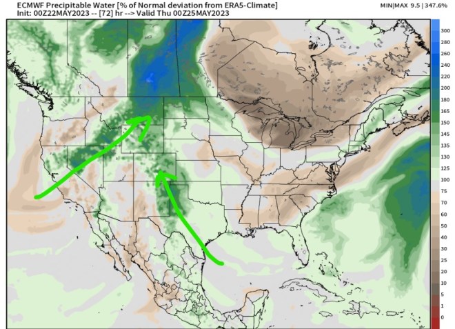
Rich Moisture

We’re seeing extra moisture in the atmosphere across the Intermountain West. This helps fuel afternoon thunderstorms. I’m forecasting afternoon thunderstorms through the end of May. Below is forecast precipitable water percentage of normal deviation valid 5/26. The green/blue represent 100-200% of normal.

Forecast Wind Gusts, Summit-level

Quandary Peak, CO, Summit-level Max Gusts:

5/25: 15-20mph

5/26: 25mph

5/27: 30mph

5/28: 20mph

5/29: 20-25mph

Longs Peak, CO:

5/25: 25mph

5/26: 25mph

5/27: 20mph

5/28: 25mph

5/29: 25mph

Mount Superior, UT:

5/25: 30mph

5/26: 25mph

5/27: 30mph

5/28: 25mph

5/29: 30mph

Grand Teton, WY:

5/25: 30mph

5/26: 30mph

5/27: 30mph

5/28: 20mph

5/29: 30mph

Photos: Deep Summit Snow on 14,115′ Pikes Peak

Tomer’s Take: Luke Doyle sent me several amazing photos of crews clearing the road to the 14,115′ summit of Pikes Peak.

The bulk of this deep snow occurred during the ‘super soaker storm system’ on 5/10-5/12. I estimated 3-4 feet accumulated.

All photos are from Luke Doyle who is a senior equipment operator on Pikes Peak.

Smoke Forecast

Forecast RAP smoke model valid 5/23-5/25. Bottom line, air quality across the West improves on 5/24 as smoke moves east.

Moisture Feed

Afternoon thunderstorms are likely through the end of May across the Intermountain West. But, on 5/24, 5/25, 5/26, and 5/27 feature extra moisture in the atmosphere to fuel more robust afternoon rain/thunderstorms.

Below is forecast precipitable water percentage of normal valid 5/24. The green/blue areas represent 100-200% of normal.

Wildfire Smoke Forecast; Afternoon Thunderstorm Pattern

Tomer’s Take: Thick smoke continues to choke MT, WY, ID, parts of UT, parts of CO, and the Great Plains through 5/23. Then, the smoke starts to move east and away late 5/23 into 5/24 with improving air quality. Also, the afternoon thunderstorm pattern is engaged through the end of May.

Smoke Forecast

Below is forecast vertically integrated smoke from the RAP model valid 5/22-5/24.

Moisture Feed

Forecast precipitable water percentage of normal is running 100-200% at times. This helps fuel afternoon thunderstorms across the Intermountain West. I expect this to continue through the end of May.

Forecast Timing

Forecast radar/satellite valid 5/22-5/27:

Snowmelt

The Western snowpack is melting rapidly, but there’s still plenty of snowpack remaining in places.

Take look at Steamboat, CO – photo by Shannon Lukens:

Current snow-water-equivalent percent of median in Colorado:

Utah:

Next Surge of Wildfire Smoke; Afternoon Thunderstorm Pattern

Tomer’s Take: The next surge of wildfire smoke from Canada is moving south. A reinforcing shot hits MT, northern UT, WY, northern CO, and the Great Plains on 5/21-5/22. And, the afternoon thunderstorm pattern is fully engaged across the Intermountain West through the end of May.

Is this normal for May? In Colorado, the answer is ‘no’. I can’t remember the last time we had an air quality advisory in the month of May. Fortunately, May is Denver’s wettest month on average. Rain helps cleanse the air.

Smoke Forecast

About 100-150 wildfires are burning in Canada (British Columbia and northern Alberta) and will push another surge of smoke into MT, WY, northern UT, and northern CO on 5/21-5/23.

RAP smoke (vertically integrated smoke) model forecast animation valid 5/20-5/22. Air quality and visibility look severe across parts of MT, ND, SD, WY, and NE.

Afternoon Thunderstorm Pattern

Extra atmospheric moisture keeps the afternoon t-storm pattern going across the Intermountain West through 5/24 and likely through the end of May.

Below is forecast atmospheric precipitable water percent of normal deviation. The green and blue shades represent above normal moisture. This helps fuel afternoon thunderstorms.

Valid 5/24:

Wildfire Smoke Inbound, Denver Drought Gone, Afternoon Thunderstorm Pattern

Tomer’s Take: Smoke from wildfires in Canada is moving south into the United States and may affect the Intermountain West air quality through this weekend. And, record rainfall 5/10-5/12 wiped out the drought in Denver. Plus, the afternoon thunderstorm pattern is in full swing along with a surge of moisture on 5/18 and early 5/19 with heavy rain potential. Finally, freezing levels stay high accelerating the Western snowpack snowmelt.

Wildfire Smoke

Below is one particular smoke forecast valid 5/19 from the RAP model (vertically integrated smoke).

Zoomed in version:

Denver Drought Gone

Before/After Slider (May 9 vs May 16). ‘Super soaker’ storm system one 5/10-5/12 largely responsible:

Forecast Freezing Levels

Wasatch Mountains, UT, Daily Max/Min:

5/18: 13000’/12500′

5/19: 13500’/12300′

5/20: 14100’/13100′

5/21: 14300’/13900′

5/22: 13900’/13100′

Colorado’s Central Mountains:

5/18: 13000’/11500′

5/19: 12800’/11500′

5/20: 14300’/12500′

5/21: 14300’/12800′

5/22: 14000’/13100′

Teton Range, WY:

5/18: 12800’/11500′

5/19: 13600’/12000′

5/20: 13600’/13500′

5/21: 14100’/13500′

5/22: 13300’/12600′

Moisture Surge

A Monsoon-esque surge of moisture will fuel a robust afternoon thunderstorms/rain pattern 5/18 and early 5/19.

Below is forecast precipitable water percent of normal deviation. Forecast values run 100-200% of normal in AZ, NM, southern UT, and CO from 5/18 through early 5/19.

Forecast Pattern

Forecast jet stream valid 5/27 shows another disturbance rolling through Colorado/NM/southern UT along with a rich southerly flow of moisture. Afternoon rain/thunderstorms are likely each day.

Forecast Timing

Forecast radar/satellite valid 5/18-5/23.

Pikes Peak nailed by 3-4 feet of snow

Tomer’s Take: The ‘Super Soaker Storm System’ on 5/10-5/12 delivered 3-4 feet of snow to Pikes Peak (14,115ft).

Photos were taken by Luke Doyle while clearing snow at Glen Cove and higher up on Pikes Peak.

Robust Precipitation

Precipitation totals 5/10-5/12. The closest CoCoRaHS observation to Pikes Peak is 3.86″ recorded in Manitou Springs.

Next, let’s get closer to Pikes Peak and look at SNOTEL sites. The closest site is Glen Cove at 11391ft. The SNOTEL sensors recorded 3.4 inches of snow-water-equivalent (SWE) by 5/12. The site added another 0.2″ of SWE on 5/13.

Bottom line, both precipitation observations are similar and in agreement.

  • Manitou Springs: 3.86″
  • Glen Cove: 3.40″

How Much Snowfall?

10:1 Ratio: 34 inches to 39 inches

12:1 Ratio: 41 inches to 46 inches

14:1 Ratio: 48 inches to 54 inches

At Glen Cove, air temps were around 30 degrees, so we’ll use 10:1.

At higher elevations, air temps were colder, so we’ll use 14:1.

Estimated snow totals:

Glen Cove likely had three feet while the upper mountain had close to four feet.

Rapid Snowmelt, Rich Moisture, Rain/Thunderstorm Pattern

Tomer’s Take: A surge of warm air will kick the snowmelt into high gear in UT, WY, CO through 5/24. I’m also forecasting a rich flow of moisture on Wednesday-Thursday this week with afternoon rain/t-storm chances each day.

Forecast Freezing Level

Wasatch Mountains, UT, Daily Max/Min:

5/15: 13600’/12800′

5/16: 13600’/13500′

5/17: 13600’/13000′

5/18: 13500’/13000′

5/19: 13600’/12800′

Colorado’s Central Mountains

5/15: 13800’/11800′

5/16: 14400’/12100′

5/17: 14600’/12500′

5/18: 13500’/12000′

5/19: 11800’/11700′

Teton Range, WY:

5/15: 12800’/11800′

5/16: 12800’/12000′

5/17: 13000’/11800′

5/18: 13100’/12100′

5/19: 13800’/12600′

Current Snowpack

Wyoming, Snow-water-equivalent percentage of median:

Colorado, Snow-water-equivalent percentage of median:

Utah, Snow-water-equivalent percentage of median:

Forecast Pattern

Forecast jet stream valid 5/18. Notice the small jet wind sliding through WY, CO. That’s a backdoor front that will focus extra moisture over the Intermountain West. I’m forecasting a higher chance for afternoon rain/t-storms on Wednesday-Thursday-Friday in MT, UT, CO, NM, WY.

Rich Moisture

Forecast precipitable water values run high on Wednesday-Thursday. Percentage of normal values increase to 200% of normal over MN, AZ, southern UT, southern CO.

This extra moisture in the atmosphere will fuel afternoon rain/t-storms each day.

Forecast Timing

Forecast radar/satellite valid 5/15-5/20. Afternoon rain/t-storms likely each day – especially Wednesday-Thursday-Friday.

Forecast Snow Totals

5/15-5/24:

Rapid Snowmelt Coming to UT, CO, WY

Tomer’s Take: Freezing levels will rise quickly and stay high through 5/23. And, there’s a lot of snowpack remaining. Plus, the pattern remains wetter than normal on 5/14, 5/15, and 5/18 with rain showers/thunderstorms likely even at mid/high elevations.

Forecast Freezing Level

Wasatch Mountains, UT, Daily Max/Min:

5/14: 12800’/11800′

5/15: 13600’/12600′

5/16: 13800’/13600′

5/17: 13600’/13100′

5/18: 13800’/13000′

Colorado’s Central Mountain Zone, Daily Max/Min:

5/14: 12000’/10700′

5/15: 13600’/11500′

5/16: 14300’/12300′

5/17: 14400’/12800′

5/18: 14600’/12000′

Teton Range, WY:

5/14: 11800/10200′

5/15: 12800’/12800′

5/16: 12800/12000′

5/17: 13000’/12000′

5/18: 12300’/11200′

Max Air Temps 5/16, 1pm

Max air temps reach the 60-70F range at Snowbird/Alta, Wasatch Mountains, UT:

Max air temps reach the 50-55F range across the Teton Range, WY:

Current Snowpack

Utah Snow-Water-Equivalent (SWE) Percentage of Median:

Colorado Snow-Water-Equivalent (SWE) Percentage of Median:

Rich Moisture Flow 5/14, 5/15, and 5/18

Forecast precipitable water % of normal valid 5/18, Monsoon-esque:

Forecast Pattern

Forecast jet stream valid 5/23. Most of the West is under the influence of a high pressure ridge. This accelerates the snowmelt.

Forecast Timing

Forecast radar/satellite valid 5/14-5/19:

Forecast Snow Totals

High freezing levels equates to very little snow.

Weekend Wind, Freezing Levels, and Monsoon-esque Flow

Tomer’s Take: A rich flow of moisture moves into CO and NM 5/13-5/15. It resembles the Monsoon, which typically occurs in July-August. There is a little snow in the forecast above 11,000ft.

View from the Continental Divide at Loveland Ski Area this morning. I’m forecasting light snow tonight with a better chance of accumulating light/moderate snow on Sunday and early Monday (5/14-5/15).

Forecast Freezing Level

Wasatch Mountains, UT, Daily Max/Min

5/13: 11500’/10800′

5/14: 13100’/10800′

5/15: 13800’/13000′

5/16: 13800’/13500′

Colorado’s Southern Mountains:

5/13: 12100’/10700′

5/14: 12500’/10800′

5/15: 14300’/11800′

5/16: 15000’/13100′

Forecast Wind Gusts

Mount Superior, UT, Max Gust:

5/13: 25mph

5/14: 35mph

5/15: 20mph

5/16: 15mph

Quandary Peak, CO, Max Gust:

5/13: 20mph

5/14: 25mph

5/15: 20mph

5/16: 25mph

Forecast Pattern

Forecast Jet stream valid 5/14. Notice the light wind across the Intermountain West. And, that wind has turned southerly. This opens the door for new moisture transport from the Gulf of Mexico.

Rich Moisture Transport: Precipitable Water Anomalies run high (+2 standard deviations) on 5/14-5/15, especially in NM & CO.

Forecast jet stream valid 5/22. High pressure ridging and light wind across the Intermountain West.

Forecast Timing

Forecast radar/satellite valid 5/13-5/18. Notice the rich moisture feed on 5/14-5/15 in Colorado and New Mexico. Rain is likely with very high mountain snow.

Forecast Snow Totals

5/13-5/22:

Foot of snow in Colorado; Monsoon-esque Flow 5/14-5/15

Tomer’s Take: A foot of snow has fallen above 10,000ft in parts of Colorado including Arapahoe Basin and Loveland Ski Area. 4-day rain totals in Denver now exceed four inches! What’s next? This storm system exits Colorado but a new push of moisture is likely 5/14-5/15. It resembles a Monsoon flow normally seen in July-August.

Arapahoe Basin, CO is reporting 13 inches of new snow in the last 48.

Loveland Ski Area is coated in 10-12 inches of new snow.

Forecast Freezing Level

Colorado’s Central Mountain Zone, Daily Max/Min:

5/12: 12500’/10000′

5/13: 11600’/10500′

5/14: 11600’/10600′

5/15: 12800’/11800′

5/16: 14400’/12500′

Wasatch Mountain, UT:

5/12: 11300’/10300′

5/13: 11600’/11000′

5/14: 12800’/12000′

5/15: 13500’/12600′

Record Rainfall in Denver

Some of the biggest rainfall totals since the 2013 Flood but that occurred in September.

4-Day Totals:

Forecast Pattern

Forecast jet stream valid 5/14. Notice the light jet winds now turning from the South. This will open the door and escort new Monsoon-esque moisture into NM, AZ, CO, and parts of UT.

Forecast jet stream valid 5/20. Big high pressure ridging and light flow. Some moisture surging from the south continues.

Forecast Timing

Forecast radar/satellite valid 5/12-5/17:

Forecast Snow Totals

5/12-5/20: