Tomer’s Take: A surge of warm air will kick the snowmelt into high gear in UT, WY, CO through 5/24. I’m also forecasting a rich flow of moisture on Wednesday-Thursday this week with afternoon rain/t-storm chances each day.
Forecast Freezing Level
Wasatch Mountains, UT, Daily Max/Min:
5/15: 13600’/12800′
5/16: 13600’/13500′
5/17: 13600’/13000′
5/18: 13500’/13000′
5/19: 13600’/12800′
Colorado’s Central Mountains
5/15: 13800’/11800′
5/16: 14400’/12100′
5/17: 14600’/12500′
5/18: 13500’/12000′
5/19: 11800’/11700′
Teton Range, WY:
5/15: 12800’/11800′
5/16: 12800’/12000′
5/17: 13000’/11800′
5/18: 13100’/12100′
5/19: 13800’/12600′
Current Snowpack
Wyoming, Snow-water-equivalent percentage of median:

Colorado, Snow-water-equivalent percentage of median:

Utah, Snow-water-equivalent percentage of median:

Forecast Pattern
Forecast jet stream valid 5/18. Notice the small jet wind sliding through WY, CO. That’s a backdoor front that will focus extra moisture over the Intermountain West. I’m forecasting a higher chance for afternoon rain/t-storms on Wednesday-Thursday-Friday in MT, UT, CO, NM, WY.

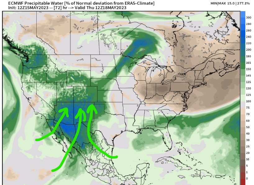
Rich Moisture
Forecast precipitable water values run high on Wednesday-Thursday. Percentage of normal values increase to 200% of normal over MN, AZ, southern UT, southern CO.
This extra moisture in the atmosphere will fuel afternoon rain/t-storms each day.

Forecast Timing
Forecast radar/satellite valid 5/15-5/20. Afternoon rain/t-storms likely each day – especially Wednesday-Thursday-Friday.
Forecast Snow Totals
5/15-5/24:
