Strong May cold front

Tomer’s Take:

  • A strong cold front remains on track for MT, WY, and CO between 5/19-5/20.
  • Forecast atmospheric pressure anomalies run 2-3 standard deviations below the 30-year average.
  • The bulk of snow falls in SW MT and on CO’s Continental Divide-East.
  • Yellowstone could see 1″ of accumulation. Big Sky and Cooke City could see several inches of accumulation.
  • Air temps in parts of Colorado drop 30-40 degrees.
  • Snow levels could drop to the valley floor.
  • Strong winds precede this cold front.

Infrared satellite shows the storm track and two large storm systems lined-up. The first storm system delivers the strong cold front while the 2nd storm system amplifies the high pressure ridge and jet stream.

Infrared satellite 5/17/2022 8am.

Pressure Pattern

An abnormally large trough rotates through the Intermountain West 5/19-5/20. Again, forecast atmospheric pressure anomalies run 2-3 standard deviations below the 30-year average.

Forecast atmospheric pressure anomalies valid 5/19-5/20, GFS interpretation.

Snow Forecast

5/17-5/26:

Inches of total snow 5/17-5/26.

Snow chance for Colorado, Wyoming, Montana

Tomer’s Take:

  • A strong late-season dip in the jet stream could deliver snow 5/19-5/20 to MT, WY, and CO.
  • Snow levels fall significantly to the valley floor in some locations. Frost/Freeze is also possible.
  • Forecast atmospheric pressure anomalies could run 2-3 standard deviations from the 30-year average.
  • Strong wind 30-80mph ahead of this storm system.

I took the skis out on Saturday near Torreys Peak in Colorado. It was a beautiful day and snow was melting quickly.

5/14/2022.

Current Setup

Infrared satellite shows the storm track and strong low pressure system pulling out of the Gulf of Alaska.

Infrared satellite 5/16/2022 5am.

Late Season Anomaly

Below, this is a robust storm system and important by May standards. Forecast atmospheric pressure anomalies run 2-3 standard deviations from the 30-year averages.

Forecast atmospheric pressure anomalies valid 5/20/2022, GFS interpretation.

Forecast Wind Gusts

Gust (MPH)5/175/185/195/20
Crestone Peak35407045
Quandary Peak25356035
Mount Sneffels35355055
Kings Peak30306040
Wheeler Peak30355555
Grand Teton30406535

Snow Forecast

5/16-5/25:

Inches of total snow 5/16-5/25.

Pattern through end of May

Tomer’s Take:

  • High pressure rebuilds across the West 5/13-5/18. The storm track shifts into the PNW/B.C.
  • Then pressures might drop with a large trough and dip in the jet stream 5/19-5/25.
  • Beyond 5/25? High pressure might rebuild.
  • What are the possible effects of a large trough 5/19-5/25? Colder than normal temps, mountain snowfall, and strong wind by May standards.
  • Dust continues be a significant problem across parts of the West including UT and CO. New dust is being transported in as I write this column. The dust decreases snowpack albedo and accelerates snowmelt. This is likely the most dust since 2009.

Wasatch Dust

Look at the dust layers lurking in the Wasatch as presented by Dr. McKenzie Skiles:

In Colorado, MODIS satellite with MAIAC Aerosol Optical Depth overlay really paints the smoky/dusty picture.

MODIS MAIAC Aerosol Optical Depth overlay 5/12/2022.

Current Setup

Infrared satellite shows the storm track and powerful jet stream running through the Intermountain West.

Infrared satellite 5/12/2022 9am.

5/19-5/25

A large trough of low pressure is possible across the West. Below, notice the atmospheric pressure anomalies. After 5/25? High pressure might rebuild.

Forecast pressure anomalies valid 5/21/2022, EPS interpretation.

Wind Gust Forecast

Notice how winds relax as high pressure rebuilds 5/13 and after.

Gust (MPH)5/125/135/145/15
Little Bear Peak65403535
Quandary Peak55403525
Mount Sneffels55303025
Kings Peak55403025
Humphreys Peak40253535
Grand Teton45554020

Snow Forecast

5/12-5/21:

Inches of total snow 5/12-5/21.

Rollercoaster out West; Strongest May La Nina since 2000

Tomer’s Take:

  • Latest La Nina May readings show -1.2C water temp anomalies (NINO 3.4 region). This is the strongest May La Nina since 2000.
  • This means La Nina is driving the overall Western pattern.
  • Western trough stays in place through 5/13 then higher pressures rebuild.
  • What about the rest of May? Lower pressures could move back in from 5/19 through 5/31.
  • A powerful western jet stream keeps strong winds across the Intermountain West through 5/13 then wind relaxes.
  • Blowing dust continues to be a significant problem. In some places like UT and CO this is the most dust since 2009.

La Nina

The latest forecasts keep La Nina in place through Fall 2022.

Current Setup

Infrared satellite shows the storm track and storm systems lined-up.

Infrared satellite 5/11/2022 6am.

High Pressure Transition

High pressure rebuilds across most of the Intermountain West on 5/14.

Forecast pressure anomalies valid 5/15, GFS interpretation.

Wind Gust Forecast

Gusts (MPH)5/115/125/135/14
Crestone Peak70754030
Quandary Peak45554535
Mount Sneffels60503030
Humphreys Peak60302530
Wheeler Peak45504035
Kings Peak60353540

Dirty Snowpack

Dust radiative forcing shows just how high the dust concentration is in Colorado (orange/red dots), especially in the Southern Mountains where it’s forcing the snowpack to melt faster than normal.

Dust radiative forcing 5/11/2022.

Snow Forecast

5/11-5/20:

Inches of total snow 5/11-5/20.

Windy week ahead

Tomer’s Take:

  • A large trough and powerful jet stream control the West through 5/15 then might break.
  • The jet stream paints the West with strong winds through 5/15. High wildfire danger.
  • The main storm track runs through northern CA, PNW, northern UT, ID, MT, and WY. This leaves southern UT, CO, NM, AZ on the drier and windy side of the jet stream.
  • The Spring Melt is kicking into high gear. The various dust layers are likely accelerating the melt.

Infrared satellite shows the storm track. This pattern leaves southern UT, CO, AZ, and NM on the drier and windy side of the jet stream.

Take a look at Snowbird, UT this morning where 12″ of new snow is reported:

Wind Gust Forecast

Forecast (MPH)5/95/105/115/12
Crestone Needle80606565
Quandary Peak60404050
Mount Sneffels70555545
Humphreys Peak70555565
Wheeler Peak65455045
Kings Peak45605530
Mount Whitney75553525

Beyond 5/15

The pattern might shift after 5/15 with higher pressures replacing the big Western trough.

Below, notice the higher pressure anomalies building across the West on 5/16.

Forecast pressure anomalies valid 5/16/2022, EPS interpretation.

Dirty Snowpack

Significant amounts of dust (possibly the most since 2009) were deposited on the snowpack across UT and CO. Here’s the view at Wolf Creek ski area this morning. Snow is dirty and melting quickly. It was a 385-inch season at Wolf Creek.

Wolf Creek ski area 5/9/2022.

Snow Forecast

5/9-5/18:

Windy pattern returns 5/7-5/15

Tomer’s Take:

  • A powerful jet stream returns to the West through 5/15. It resembles April.
  • The future storm track keeps the bulk of precipitation north of Colorado through 5/15. This leaves Colorado and much of the Intermountain West in a windy pattern.
  • Blowing dust is again possible.
  • The best chances for snow stays in northern UT, WY, ID, MT, and PNW.

Infrared satellite shows the storm track and storm systems lined-up. They’re riding a powerful jet stream.

Infrared satellite 5/6/2022 7am.

Wind Gust Forecast

Forecast (MPH)5/75/85/95/10
Crestone Needle70757060
Quandary Peak50605535
Mount Sneffels60707050
Humphreys Peak65706050
Wheeler Peak50606045
Kings Peak45605555

Jet Stream

A powerful jet stream returns to the West resembling April. It’s following La Nina architecture. The yellow/orange/red colors represent the strongest winds.

GFS interpretation valid 5/8-5/9/2022.

Snow Forecast

5/6-5/15:

Inches of total snow 5/6-5/15.

Everest Weather

Enjoyed a conversation yesterday with Alan Arnette, Michael Fagin, and Marc DeKeyser. The focus is on Everest Weather. Michael and Marc are fellow cohorts who provide weather forecasts and guidance to teams climbing Everest (and other peaks).

You can watch our discussion by clicking here.

Dirty snowpack: Most dust since 2009?

Tomer’s Take:

  • The dust storm on 4/22 was one for the books. Dust was deposited on most of the high mountain snowpack – especially the Southern Mountains.
  • This could be the most significant layer of dust since 2009. Here’s a look back at 2009 in a paper I co-authored.

Dr. McKenzie Skiles at the University of Utah snapped this photo looking into the Wilson Massif in the San Juan Mountains of Colorado.

Dirty, dusty San Juan snowpack, end of April 2022. Dr. McKenzie Skiles.

Here’s a look back at the 4/22 dust storm with wind gusts of 50-90mph. Notice how much dust was entrained on the MODIS satellite image with dust/smoke overlay.

MODIS satellite 4/22 with dust/smoke overlay.

MODIS satellite also has a feature that can look at “Dust Radiative Forcing”. Dust increases radiative forcing and promotes faster melting of the snowpack. Below, is the current satellite image as of 5/2.

Obviously, the Southern Mountains have high amounts of dust. I suspect the Central and Northern Mountains have more dust than what’s being detected. Why? It continues to snow in the Central and Northern Mountains covering up the dust from 4/22. The Southern Mountains have been relatively dry since 4/22 with very little snow. Eventually those dust layers in the Central and Northern Mountains will be revealed as the snow melts.

Below is a look at the current dust radiative forcing versus history. It’s clearly outside of the normal range.

How does this process work? The snowpack melts faster sending water downstream earlier and faster than normal.

Strong wind returns 5/8-5/15

Tomer’s Take:

  • A minor storm system is spinning through the Intermountain West this morning with rain and snow.
  • A larger storm system and dip in the jet stream is waiting in the Gulf of Alaska. This will drive the pattern across the West between 5/8-5/15. Some places get snow while others get mainly wind.
  • The bulk of snow 5/8-5/15 falls in CA, ID, MT, WY, and northern UT.

Infrared satellite shows the storm track and large low pressure in the Gulf of Alaska.

Infrared satellite 5/4/2022 5am.

A large dip in the jet stream and atmospheric pressure anomalies occur across the West 5/8-5/15.

Forecast atmospheric pressure anomalies valid 5/12/2022, GFS interpretation.

Wind Gust Forecast

Forecast (MPH)5/85/95/105/11
Crestone Needle60757575
Quandary Peak45604055
Mount Sneffels65757075
Kings Peak65605555
Wheeler Peak55605050
Mount Whitney80553035

Snow Forecast

5/4-5/13:

Inches of total snow 5/4-5/13.

Snow forecast next 8 days

Tomer’s Take:

  • La Nina continues to anchor the pattern across the West through mid-May. It’s the strongest April/May La Nina since 1999.
  • I’m expecting above normal levels of wind, snow, and rain.
  • Across the Intermountain West, a larger dip in the jet stream and trough of low pressure still possible 5/8-5/13.
  • Conditions might ease the 2nd half of May.

Infrared satellite shows the active storm track and larger low pressure sitting in the Gulf of Alaska. This becomes the dominate force through 5/13.

Infrared satellite 5/3/2022, 6am.

5/8-5/13

Falling pressures are still possible with a dip in the jet stream between 5/8-5/13. Uncertainty remains high regarding precipitation placement. Of higher certainty is strong wind. A trough of this size would deliver abnormally strong wind across the Intermountain West.

Atmospheric pressure anomalies valid 5/9/2022, GFS interpretation.

Wind Gust Forecast 5/8-5/11

Forecast (MPH)5/85/95/105/11
Crestone Peak75857585
Quandary Peak50555060
Mount Wilson60656575
Wheeler Peak50555050
Kings Peak60455555
Mount Whitney65553035

Snow Forecast

5/3-5/12:

Inches of total snow 5/3-5/12.

Strongest April/May La Nina since 1999

Tomer’s Take:

  • Nino 3.4 region water temps are currently -1.1C. That’s the coldest water temp in this region since 1999.
  • This anchors the atmosphere and the current pattern continues through May.
  • I’m forecasting an active month of May across the Intermountain West with above normal amounts of rain, snow, and wind.
  • The jet stream is following La Nina architecture and sitting over the PNW, ID, northern Utah, southwest MT, Wyoming, and the Central and Northern Mountains of Colorado.
  • I’m tracking a larger dip in the jet stream between 5/8-5/11. Atmospheric pressure anomalies could run 2-3 standard deviations below the 30 year average. This could translate into heavy mountain snow and strong wind.

Important La Nina update from Philip Klotzbach at CSU:

La Nina Spring & Summer

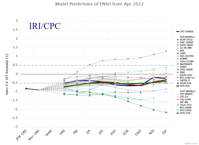
The latest CPC/IRI forecast from mid April keeps La Nina (blue bars) through Summer and possibly through Fall.

ENSO forecast, Mid-April 2022.

Here’s the model forecast spread. Water temps are already starting colder than what this model suite initialized.

Long running La Nina, the two-year view:

Storm Track

Infrared satellite shows the storm track and large storm system sitting in the Gulf of Alaska. This is the low pressure to watch for 5/8-5/11.

Infrared satellite 5/2/2022 9am.

Below, notice the forecast pressure anomalies around 5/8-5/9 across the Intermountain West. Strong wind, colder temps, and heavy mountain snow if this verifies.

Forecast pressure anomalies around 5/9, GFS interpretation.

Snow Forecast

5/8-5/11:

I took a middle of the road approach to these numbers. It’s still a long way out but there’s potential.

Inches of total snow 5/8-5/11.