The next Monsoon surge occurs over the Mountains between Friday afternoon and Monday morning.
The bulk of the precipitation occurs over the Southern Mountains with less impact as you go North.
Overall, this is a moderate surge. Not as big as last week. Primary impact is for higher chances of midday/afternoon/evening rain and thunderstorms.
It means smaller recreation windows but most mornings should be dry.
Current Setup
It’s beautiful morning Telluride. This illustrates how weather normalizes in between Monsoon surges.
Telluride, CO, 8/3/2022 6:30am.
The bulk of Monsoon moisture is currently to the Southwest of Colorado. The key high pressure is sitting just south of Colorado in New Mexico. By this weekend, the high pressure moves east and opens the door for the surge.
Water vapor satellite, middle atmosphere, 8/3/2022 6am.
By the weekend, the door is wide open and precipitable water values are above 100%.
Precipitable water valid Saturday 8/6/2022, GEFS model.
Forecast
Mount Eolus
AM
PM
8/5
Dry
100%
8/6
Dry
100%
8/7
Dry
100%
Mount Eolus, San Juan Mountains, Colorado
NWS digital point forecast for 13,000ft Central Mountains near Twin Lakes/Mount Elbert valid 8/5-8/6.
Andrea Sansone climbed 12 14ers in 22hrs16min (supported).
Eric Lee set the previous men’s and overall FKT with 11 14ers in 21hrs50min (supported) on 9/19/2020.
Becca Jay set the previous women’s FKT with 8 14ers in 18hrs33min (supported) on 7/8/2020.
FKT = Fastest Known Time
“This project has been a long time coming and there was so much effort from all ends. I didn’t want to let anyone on support down so when I doubted myself during the hardest moments I just had to do what I knew how to do – and that was hike,” said Andrea Sansone after setting the new overall 14er 24 hour FKT.
14ers climbed
Columbia, Harvard (2)
Belford, Oxford, Missouri (3)
Democrat, Lincoln, Bross (3)
Grays and Torreys (2)
Bierstadt, Evans (2)
Weather
Andrea Sansone and Andrew Hamilton are gracious hosts. We were sharing a wonderful enchilada dinner when the conversation quickly pivoted and Andrea said, “We’re going to start the FKT attempt on Thursday and finish Friday.” I said I need to look at those dates – I think that coincides with a Monsoon surge.
I’ve worked with Andrea and Andrew numerous times and they’re great friends. They’ll climb through almost anything. But, a 24-hour record really needs a cleaner forecast. So, we changed dates.
Andrea and Andrew.
Making it happen
Andrea shot this video on Mount Belford. You’ll notice the thunderstorms in the distance. At this point, Andrea is moving ahead and away from the thunderstorms.
Video by Andrea Sansone on Mount Belford.
Andrea shot this video on the Decalibron loop almost on the summit of Democrat. By this point the afternoon thunderstorms are dying quickly and she’s home free.
The first surge of Monsoon moisture combined with upper level jet support generated a major hailstorm in downtown Estes Park.
Golfball sized hail (or larger) fell just outside Fort Collins in Wellington, Severance, and around Timnath.
1-3 inches of rainfall with a few different lines of thunderstorms accumulated around Fort Collins and across Northern Colorado.
Another surge of moisture Thursday afternoon/night delivers similar weather along with high chances for flash flooding.
Big Event Forecast Update
Never Summer Ultra, 7/29-7/31: Dry all mornings, periods of sun, 40-70% chances for afternoon t-storms (highest % SAT-SUN afternoons). Monsoon has less effect on the Northern Mountains.
Chicago Basin 14ers, 7/28-7/30: No-go 7/28-7/29, drier mornings 7/30 & 7/31 with 80% chances for midday/afternoon rain/t-storms.
Pikes Peak Ultra, 7/30: Dry morning, 80% t-storms by Noon through afternoon.
Estes Park Hailstorm
This occurred 10pm 7/27/2022 in downtown Estes Park, CO. Video courtesy Kirby Hazelton.
Downtown Estes Park 10pm 7/27/2022, Kirby Hazelton.
One additional photo courtesy the Estes Park Police Department.
Deep hail downtown Estes Park, EPPD.
Dewpoint
Dewpoints are pegged at 60°F in Fort Collins = a clear signal of a Monsoon surge. This represents available moisture to fuel thunderstorms and flash flooding.
Robust Monsoon through 8/10
Medium/long-range data suggest above normal precipitation through at least 8/10. This strongly suggests a robust Monsoon.
The door remains wide open for an active Monsoon through 8/10.
Atmospheric moisture values run 150-300% of normal through 8/10 over parts of Colorado – especially the Mountains south of I-70. Drier north of I-70.
It’s important to time-out the surges. Life is more normal in-between surges.
Two surges in my CO forecast: 1) 7/28-7/30, 2) 8/3-8/4.
Big Events
Let’s get requests done first. I’ve had numerous forecasts requests. This info might be helpful to everyone.
San Juan Solstice Ultra, 7/30: Dry in the morning, high chance for midday/afternoon t-storms. Course will be wet from Thursday-Friday moisture surge.
Never Summer Ultra, 7/29-7/31: Dry all mornings, periods of sun, medium risk for afternoon t-storms. Monsoon has less effect on the Northern Mountains.
Chicago Basin 14ers, 7/28-7/30: No-go 7/28-7/29, drier morning 7/30 with midday/afternoon rain/t-storms likely.
Long Term Monsoon
Data suggest abnormally high amounts of precipitation through 8/10. This means the seasonal Monsoon remains robust.
From a forecasting perspective, this means afternoon rain/t-storms are likely throughout this period.
Percent of normal precip anomalies through 8/10/2022, GEFS data.
Here’s the NWS digital point forecast for 13,000ft around Twin Lakes/Leadville valid 7/28-7/29. Notice dewpoints in the 30s. That’s high for mountain environments in Colorado.
NWS digital point forecast 13,000ft around Twin Lakes/Leadville valid 7/28-7/29/2022.
Major surge of Monsoon moisture hits AZ, NM, UT, and CO Thursday-Friday.
In Colorado, this is the largest surge of the season so far.
In Colorado, the Southern Mountains get hit the hardest. Flash flooding possible starting Wednesday afternoon/night with multiple rounds of thunderstorms.
Total rainfall by 7/31 could run 1-4 inches in the Southern Mountains of CO.
Rain/t-storms might continue through the night.
Brief 14er summit snow possible late Thursday into Friday morning.
7/26 5:30am Water vapor satellite shows the seasonal Monsoon in full swing. Red/orange = drier air aloft.
Water vapor satellite 7/26/2022 5:30am.
Surge Forecast
I’ve had numerous forecast requests for late week and weekend from hikers, trail runners, and mountaineers. I’m also looking at longer range trends for Nolan’s.
This is a major surge for areas south of I-70 in Colorado between Wednesday night and Saturday night. Peak moisture occurs Thursday-Friday.
I consider Thursday-Friday “no go” days on the 13ers/14ers in the Southern Mountains. But, Wednesday afternoon and Saturday should also be approached with caution as moisture levels stay high.
Forecast Precipitation Chances:
Mount Eolus
AM
PM
7/27
10%
100%
7/28
50%
100%
7/29
90%
100%
7/30
70%
100%
7/31
0%
50%
Mount Eolus precipitation forecast.
Digital hourly forecast for 13,000ft around Mount Elbert valid 7/28-7/29:
Forecast for 13K around Mount Elbert valid 7/28-7/29.
Forecast rain grand totals by 7/31.
Forecast rainfall grand totals by 7/31, EPS model.
The Monsoon is 1-2 weeks earlier than normal and it’s here to stay (normal Monsoon season is July-August in Colorado).
The first official surge of the season occurred last weekend.
This weekend’s surge looks bigger and intensity peaks on Saturday.
The biggest impact occurs in the San Juan and Sangre De Cristo Mountain ranges. Plan on small weather windows with early/late/overnight rain/t-storms/summit snow chances.
Forecast precipitable water values push 200% of 30-year averages over Southwest and Southern Colorado.
Forecast precipitable water % of 30-year averages, GFS interpretation.
Below is the Central Sawatch hourly forecast for Saturday 6/25 – Sunday 6/26 at about 12,500ft. What you don’t see here is a snow chance for the 14ers. I could see 1-4 inches on some 14ers in the Sawatch, Sangres, and San Juan Mountains.
NWS digital hourly forecast from 6/21/2022.
Looking ahead to 4th of July weekend
We could see another Monsoon surge for 4th of July weekend (7/1-7/4).
Forecast precipitable % of 30-year average, GFS interpretation.
A surge of pre-Monsoon season moisture hits Colorado Saturday-Monday. Normal Monsoon season runs July-August.
The areas most affected are the Western Slope and Southern Mountains of Colorado.
Precipitable water increases to 200% of June 30-year average values.
Bottom line: plan on smaller weather windows. Expect mountain thunderstorms by 10am or earlier across the Western Slope and Southern Mountains. And, overnight/morning rain is possible in the San Juan’s on Sunday morning and possibly Monday morning.
Colorado state climatologist Dr. Russ Schumacher says it’s a robust moisture surge by June standards:
quite the change in moisture upcoming in western Colorado…precipitable water (amount of water vapor in the atmosphere) at Grand Junction goes from near-record low today to near-record high for mid-June by the weekend. Finally some rain on the way for the western slope! #cowxpic.twitter.com/KSys7xaWU9
Total maximum new snow between 5/20-5/25 above treeline in the Sangre De Cristo’s likely ranged from 1-4 feet. Amounts below treeline were likely on the low end of this range with melting and compaction.
The biggest totals might favor East facing slopes.
SWE maxed out at 4.1″ over Hayden Pass and 3.8″ at South Colony 5/20-5/25.
A sharp cut-off might exist (N to S) with a lot less snow accumulation south of the Crestone Group.
Three straight days of wind gusts to 65mph likely generated significant drifting.
Custer County Search and Rescue is warning Memorial Day Weekend hikers and climbers. Full winter gear on the 13ers and 14ers.
New Snow 5/20-5/25
A guess at maximum new snow 5/20-5/25 (assuming all snow and no mixing):
Crestone Peak: 38″ (3.8″ SWE)
Hayden Pass: 41″ (4.1″ SWE)
Rio Alto Peak: 36-41″
Air temps below treeline warmed above freezing most days suggesting snow compaction and melting.
Snow depth as of 5/26.
Snow Forecast
A cold front delivers new snow to Colorado 5/29-5/30.
Mountain and Foothill totals ranged from 1 to 2.5ft. This is in-line with forecast amounts.
Ratios ranged from 10:1 to 14:1. That made 12:1 the average storm ratio, which is low for many Colorado mountain zones. Mid-winter ratios run 14:1 or higher.
Snow density was high with SWE ranging from 1″ to 2.7″. This is invaluable for wildfire suppression, drinking water, recreation, and agricultural needs.
As you’ll see below, a number of critical meteorological variables combined to generate this major Colorado snowstorm.
The most recent late May storm system of this magnitude occurred in 2019 on the heels of the biggest, most destructive winter in Colorado mountain history.
Totals
Never Summer Range 32.4″ (2.7″ SWE)
Echo Lake 25.2″ (2.1″ SWE)
Breckenridge 18.6″
Longs Peak 18″+ (1.5″ SWE)
Mount Audubon 18″ (1.5″ SWE)
St Mary’s Glacier 18″
Loveland Pass 18″ (1.5″ SWE)
Hoosier Pass 18″ (1.5″ SWE)
Alma 17″
Berthoud Pass 16.8″ (1.4″ SWE)
Copper Mountain 16.8″
Nederland 16.5″
Crestone Peak 14.4″ (1.2″ SWE)
Grand Lake 11″
Setup
Infrared satellite from 5/20-5/21 shows the storm track and cold front across Colorado. Notice the brighter colors across the Divide, Foothills, and Front Range representing colder, higher cloud tops.
Air temperatures dropped 30-50 degrees rapidly behind this cold front. The cold pool extended high into the atmosphere.
The dip in the jet stream and trough were major for late May. Some atmospheric pressure anomalies were running 2-3 standard deviations below the 30-year average.
Front Range surface wind was firmly upslope and ran east to west ascending through the Foothills to the crest of the Continental Divide. This was a major orographic setup.
Infrared satellite
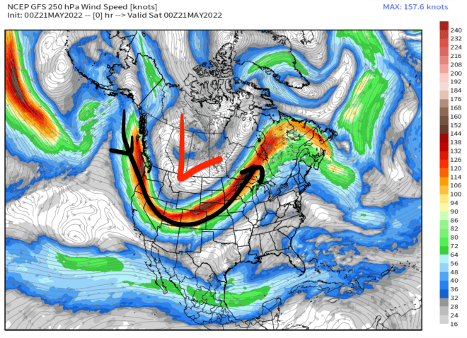
Meanwhile, a 150mph jet stream was roaring over the top of Colorado on a SW to NE orientation.
250mb setup 5/20-5/21, GFS interpretation.
But, you really need to zoom-in and look the mesoscale situation. Below, you notice the jet streak left exit region places maximum lift/diffluence right where the biggest totals occurred.
Overall, it was a combination of critical meteorological variables that generated this strong late season snowstorm.
250mb setup valid 5/20-5/21, HRRR interpretation.
Parting Shots
Gary Fondl (Mayor of Powtown) enjoys the Mayuary snowstorm with @chrisjfish in the backcountry.
May 2022.
I took this shot in the Foothills during my workout where I found about a foot of fresh snow.
May 2022.
A-Basin sent this photo and featured 15-18″+ of powder skiing.
A major late May snowstorm is on track with the biggest overall totals falling across Colorado’s Foothills and Continental Divide above 6,000ft.
This cold front will first slide south through MT and WY with minor snow accumulation.
Strong wind precedes this storm system.
Current Setup
Infrared satellite shows the storm track. The low pressure across the northern tier is dragging a major cold front. That’s the cold front headed for MT, WY, and CO.
Infrared satellite 5/19/2022 6am.
Forecast Snow
Let’s talk bullseyes. Here’s a look at Longs Peak (14,259′) in Colorado this morning. I’m forecasting 24-36″ on Longs between Friday-Saturday.
This is a classic Front Range setup with major upslope orographic wind flow favoring the Divide-East in Colorado.
Longs Peak 5/19/2022.
Here are my forecast totals by day.
Snow (Inches)
5/20
5/21
Longs Peak
15
15
Mount Bierstadt
15
15
Berthoud Pass
12
8
Mount Elbert
4
10
Peak 8 Breck
4
12
Mount Harvard
2
13
Crestone Peak
2
8
Mount Sneffels
1
2
Denver Metro
2
2
5/19-5/28:
There’s a 2nd much smaller storm system that slides through Colorado’s mountains between 5/22-5/23 with minor additional accumulation.
Inches of total snow 5/19-5/28.Inches of total snow 5/19-5/28.