Tomer’s Take:
- Nino 3.4 region water temps are currently -1.1C. That’s the coldest water temp in this region since 1999.
- This anchors the atmosphere and the current pattern continues through May.
- I’m forecasting an active month of May across the Intermountain West with above normal amounts of rain, snow, and wind.
- The jet stream is following La Nina architecture and sitting over the PNW, ID, northern Utah, southwest MT, Wyoming, and the Central and Northern Mountains of Colorado.
- I’m tracking a larger dip in the jet stream between 5/8-5/11. Atmospheric pressure anomalies could run 2-3 standard deviations below the 30 year average. This could translate into heavy mountain snow and strong wind.
Important La Nina update from Philip Klotzbach at CSU:
La Nina Spring & Summer
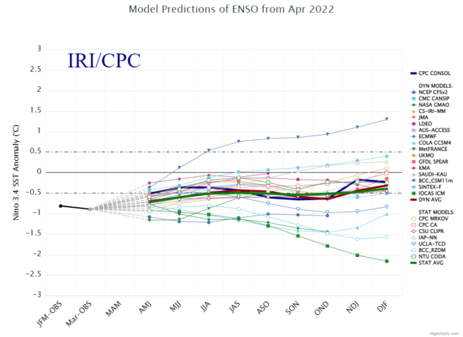
The latest CPC/IRI forecast from mid April keeps La Nina (blue bars) through Summer and possibly through Fall.

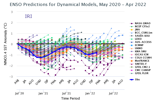
Here’s the model forecast spread. Water temps are already starting colder than what this model suite initialized.
Long running La Nina, the two-year view:

Storm Track
Infrared satellite shows the storm track and large storm system sitting in the Gulf of Alaska. This is the low pressure to watch for 5/8-5/11.

Below, notice the forecast pressure anomalies around 5/8-5/9 across the Intermountain West. Strong wind, colder temps, and heavy mountain snow if this verifies.

Snow Forecast
5/8-5/11:
I took a middle of the road approach to these numbers. It’s still a long way out but there’s potential.

I don’t recall a stretch of weeks like this where surface winds have been this strong for so long. What you said above helps explain partly why this is the case
Thanks, Randy! Chris
Truth I have been surfing the pacific all week in Baja and have never experienced it this cold!!!
Thanks, Gerlinde! Chris
Hi Chris! Do you think that trough from 5/8-5/11 will bring frost/freeze temps to Denver? Thanks in advance!
Hi Scott, I do think that’s possible…potentially a frost at 32. The timeline might shift a couple days to include 5/12 and 5/13. It’s not a lock, but I’d put the chance at this point around 30%.
Chris
What does this mean for severe weather along the front range?
Hi Tony – Normally, La Nina increases the odds for hail and tornadoes. Chris
Hey Chris,
We’re in Black Hawk and we’re really starting to worry about how dry it is. Can you offer any specifics about snow/rain for Black Hawk?
Hi Ned, you’ll get rain/snow today then it’s back to drier. This strong La Nina brings back windy conditions most of next week. Looking down the road, the second half of May might stay drier with wind. Chris