Tomer’s Take:
- A strong cold front remains on track for MT, WY, and CO between 5/19-5/20.
- Forecast atmospheric pressure anomalies run 2-3 standard deviations below the 30-year average.
- The bulk of snow falls in SW MT and on CO’s Continental Divide-East.
- Yellowstone could see 1″ of accumulation. Big Sky and Cooke City could see several inches of accumulation.
- Air temps in parts of Colorado drop 30-40 degrees.
- Snow levels could drop to the valley floor.
- Strong winds precede this cold front.
Infrared satellite shows the storm track and two large storm systems lined-up. The first storm system delivers the strong cold front while the 2nd storm system amplifies the high pressure ridge and jet stream.

Pressure Pattern
An abnormally large trough rotates through the Intermountain West 5/19-5/20. Again, forecast atmospheric pressure anomalies run 2-3 standard deviations below the 30-year average.

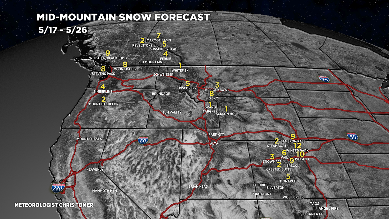
Snow Forecast
5/17-5/26:

Downtown Castle Rock snow 🧐🧐
Bonnie, it sure looks that way. Chris
We’ll take every inch we can get up here at Mount Vernon!
Yes! Thanks, Scott.
Well there goes the rose bushes.
Hi JimS – I know, i’d like to have the precipitation but not the freezing temps.
Should flowers in pots be pulled inside??
Thanks
Hi Roy – that’s what i’m planning on doing Friday night into Saturday morning. Chris
Chris, looks like the isobar lines are far apart for us in NE NM, hopefully that means we won’t have these winds that are fanning this monster fire? Thanks, I still keep up with you even after being a New Mexican for a year now! Keep up the work, It helps.
jeff ( formally Jeff Wilson – Arvada )
Hi Jeff – it does look like consistent 50mph gusts are likely on Thursday and Friday over the higher peaks. Some precipitation is also possible between Friday night and Saturday morning. Chris
This is great….water! Pretty moist here in Frisco….but we’ll take it.
Hopefully hammer time at the Basin!!!
Clay – it should nail A-Basin. This is incredible moisture.