Tomer’s Take:
- Mountain and Foothill totals ranged from 1 to 2.5ft. This is in-line with forecast amounts.
- Ratios ranged from 10:1 to 14:1. That made 12:1 the average storm ratio, which is low for many Colorado mountain zones. Mid-winter ratios run 14:1 or higher.
- Snow density was high with SWE ranging from 1″ to 2.7″. This is invaluable for wildfire suppression, drinking water, recreation, and agricultural needs.
- As you’ll see below, a number of critical meteorological variables combined to generate this major Colorado snowstorm.
- The most recent late May storm system of this magnitude occurred in 2019 on the heels of the biggest, most destructive winter in Colorado mountain history.
Totals
- Never Summer Range 32.4″ (2.7″ SWE)
- Echo Lake 25.2″ (2.1″ SWE)
- Breckenridge 18.6″
- Longs Peak 18″+ (1.5″ SWE)
- Mount Audubon 18″ (1.5″ SWE)
- St Mary’s Glacier 18″
- Loveland Pass 18″ (1.5″ SWE)
- Hoosier Pass 18″ (1.5″ SWE)
- Alma 17″
- Berthoud Pass 16.8″ (1.4″ SWE)
- Copper Mountain 16.8″
- Nederland 16.5″
- Crestone Peak 14.4″ (1.2″ SWE)
- Grand Lake 11″
Setup
Infrared satellite from 5/20-5/21 shows the storm track and cold front across Colorado. Notice the brighter colors across the Divide, Foothills, and Front Range representing colder, higher cloud tops.
Air temperatures dropped 30-50 degrees rapidly behind this cold front. The cold pool extended high into the atmosphere.
The dip in the jet stream and trough were major for late May. Some atmospheric pressure anomalies were running 2-3 standard deviations below the 30-year average.
Front Range surface wind was firmly upslope and ran east to west ascending through the Foothills to the crest of the Continental Divide. This was a major orographic setup.

Meanwhile, a 150mph jet stream was roaring over the top of Colorado on a SW to NE orientation.
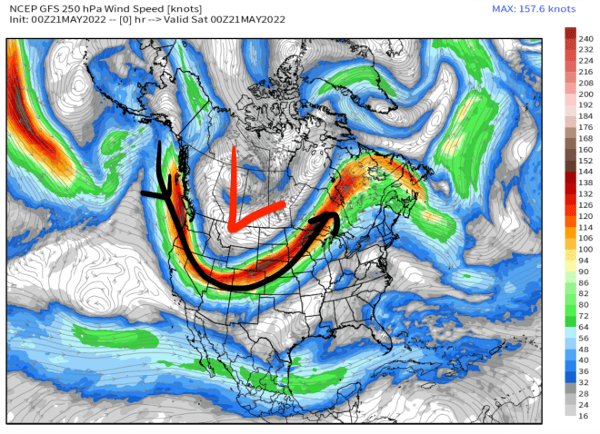
But, you really need to zoom-in and look the mesoscale situation. Below, you notice the jet streak left exit region places maximum lift/diffluence right where the biggest totals occurred.
Overall, it was a combination of critical meteorological variables that generated this strong late season snowstorm.

Parting Shots
Gary Fondl (Mayor of Powtown) enjoys the Mayuary snowstorm with @chrisjfish in the backcountry.

I took this shot in the Foothills during my workout where I found about a foot of fresh snow.

A-Basin sent this photo and featured 15-18″+ of powder skiing.

Thanks, Chris!
Great photos of much needed moisture!
Thanks!
Chris,
Do you have any totals from this storm for 13er California Peak and 14er San Luis Peak?
Hi Randy, I don’t have direct reports but triangulating from nearby observations suggests 12-17″ on California Peak and 1-4 inches on San Luis Peak. A 2nd storm system tonight, tonight, and Tuesday delivers another 5-12″ on spine of the Sangres including California Peak. Chris
Thanks Chris!
What it the ratio of that you mention at the beginning?
Hi Joe, rain to snow ratio. How much liquid equates to snow. Chris