It’s a powder day in the Wasatch, Tetons, and the Central & Northern Mountains of Colorado.
Parts of the Snowy Range and Sierra Madre in Wyoming received 30 inches or more.
There’s one more storm system sliding down the jet stream between Friday-Saturday for ID, MT, WY, UT, and CO.
Then high pressure builds and the snow machine stops (except in the PNW/B.C.) until potentially 1/14.
Powder day at Loveland Ski Area!
1/6/2022
Jackson Hole:
1/6/2022
Winter Park:
1/6/2022
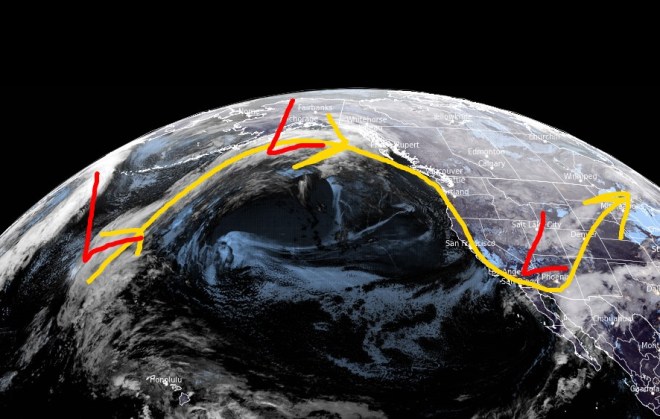
The northwest-oriented jet stream will keep the snow falling in the Wasatch, Tetons, and Central & Northern Mountains of Colorado. Notice on the infrared satellite the next low pressure hitting the Pacific Northwest. That hits the interior Rockies between Friday-Saturday.
Infrared satellite with storm track 1/6/2022 5am.
Then high pressure builds into the West. This will curtail snowfall for at least a few days across the Interior West.
Periods of heavy snow through 1/7 for the PNW with 2-3 additional storm systems. Then high pressure builds for a few days.
Jet stream shifts south through 1/8 and pushes heavy snow into ID, MT, WY, northern UT, and the Central & Northern Mountain zones of Colorado. Then high pressure builds 1/9-1/13.
Totals in the Tetons 1/4-1/8 could reach 40-50″. The bulk of snow at Jackson Hole accumulates on 1/5 and 1/6.
Totals in the Wasatch 1/4-1/8 could reach 30-36″. The bulk of snow at Snowbird accumulates on 1/5.
Unprecedented snowfall closed Timberline, OR on 1/3. I’m forecasting another 3 feet through 1/7.
Timberline Lodge.
Infrared satellite shows the storm track.
Infrared satellite 1/4/2022 5am.
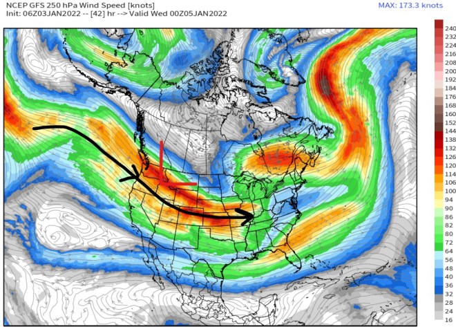
High pressure follows this storm cycle. A look at 1/10 shows a splitting jet stream and high pressure ridge over the West. It’s not bulletproof and small waves of moisture may sneak through.
Jet stream valid 1/10/2022, GFS interpretation.
Snow Forecast
Let’s look at my snow forecast in two time-periods.
1/4-1/8:
Inches of total snow 1/4-1/8.
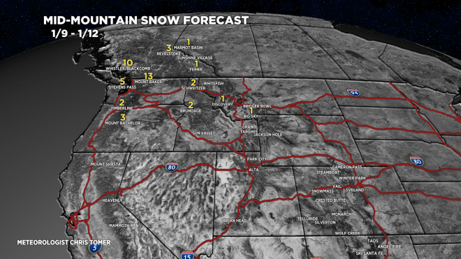
1/9-1/12: Notice the big drop-off in snowfall as higher pressures build.
Active jet stream with 3-4 storm systems for the PNW, B.C., ID, MT, and WY. Feet of total accumulation.
Then, the storm track shifts south and hits northern Utah and the Central & Northern Mountains of Colorado with major snow accumulation (1/4-1/8).
After 1/8, high pressure builds into the Intermountain West.
The key feature is the dipping jet stream and large trough of low pressure over the North Pacific. Pressures are running 2-3 standard deviations below the 30-year average. This means it’s significant.
Infrared satellite 1/3/2022 5am.
Jet Stream
A powerful jet stream directs 3-4 storm systems into the PNW and northern tier of the Rockies.
Jet stream forecast valid 1/4-1/5.
High pressure builds in after 1/8. Notice the splitting jet. Bigger storm system for the Northeast.
Jet stream forecast valid 1/10.
Snow Forecast
Total snow forecast 1/3-1/10:
Inches of total snow 1/3-1/10.
Drilling down, here’s my snow plume for Alta, UT:
Inches of total snow by 1/10.
Jackson Hole, WY:
Inches of total snow by 1/10.
Wind
Powerful jet stream through 1/8 delivers strong wind along with the heavy snowfall.
The first storm cycle of 2022 is taking shape in the Gulf of Alaska/B.C. Coast. This trough of low pressure becomes the dominant player 1/2-1/10 for the Pacific Northwest, Banff, WY, ID, MT, UT, and CO.
9-day storm cycle grand totals in Crested Butte, CO reached 99″. Another inch or so is certainly possible pushing the total to 100″. Snow-water-equivalent on Schofield Pass has reached 14.2″. That’s huge and surpasses all other years on record as far as I can tell.
Wolf Creek reached a 9-day storm cycle grand total of 118″. Another inch or so also possible there.
Silverton Mountain is reporting a 9-day storm cycle grand total of 100″.
Snow returns to UT, WY, and CO around 1/4. A few different storm systems are lined-up. For more analysis please watch my forecast video.
Final storm system merger underway for 2021 in UT, CO, NM, WY.
Looking into 2022, the storm track shifts north to favor the Pacific Northwest, British Columbia, Banff area, ID, WY, MT. Plan on major snow accumulation of 25-60″ at Stevens Pass, Baker, Rainier, Whistler/Blackcomb, Timberline, and Bachelor.
Then the jet stream shifts a little further south starting on the 4th and brushes northern UT and northern CO.
8-day storm cycle totals now stand at 89″ in Crested Butte and will likely increase to about 105″ by 1/1. Schofield Pass SWE sits at 12.3″ since 12/23. These two pieces of data suggest a top-3 storm cycle for the Crested Butte zone. It rivals March 2019 and the Bury Butte storm cycle of January 2017.
Perspective
This graph is courtesy the Crested Butte Avalanche Center and shows the biggest storm cycles on Schofield Pass since 1986.
Courtesy Crested Butte Avalanche Center.
Storm Track
Infrared satellite shows the final storm system(s) moving through UT, CO, NM and the shifting storm track for the PNW.
Infrared satellite with storm track, 12/31/2021 5am.
What’s Next?
The jet stream shifts north the first week of 2022 and favors the PNW, B.C., the northern tier of the Rockies, ID, MT, and WY. Starting on the 4th, snow will brush the Wasatch and northern zones of Colorado.
Merger of two different storm systems next 72 hours over 4-Corners marks the final piece of this historic storm cycle.
Cold blast follows this merger.
Brief break in the action across Intermountain West with small high pressure Sunday-Monday. Then next Pacific storm system hits the Intermountain West after 1/4.
Grand total storm cycle snow in Crested Butte, Silverton, Wolf Creek, and West Elks around Aspen/Snowmass should range from 100-130″ (12/23-1/1).
Wolf Creek Pass and Schofield Pass already showing 10″ of SWE.
Infrared satellite shows the storm track and both storm systems involved in merger.
Infrared satellite 12/30/2022 5am.
Forecast mid-mountain air temperatures (F) Saturday and Sunday morning:
Mid-Mountain
1/1
1/2
Alta
0
-7
Loveland
0
-19
Snowmass
8
-15
Jackson Hole
-7
-2
Crested Butte
7
-20
Forecast air temps mid-mountain (F).
Snow Forecast
Let’s look at my snow forecast in two time-periods. I added Winter Park and Ski Santa Fe to the map.
12/30-1/2:
Inches of total snow 12/30-1/2.
1/3-1/8:
Inches of total snow 1/3-1/8.
Drilling down, here’s my snow plume for Winter Park.
My forecast includes at least the partial merger of two storm systems over the 4-Corners between Thursday night and Saturday morning.
Heavy snow in UT, CO, and NM between Thursday night-Saturday morning.
In Colorado, the bullseye is Western Slope ski areas and San Juan ski areas.
This final storm system will mark the end of this prolonged and historic storm cycle.
The Intermountain West gets a brief 3-4 day dry break with snow returning quickly thereafter.
The infrared satellite shows the storm track and I marked the two storms systems that merge for New Year’s.
Infrared satellite with storm track, 12/29/2021 5am.
After this storm system departs on 1/1/2022, a small ridge of high pressure builds into the Intermountain West. This equates to a warmer, drier pattern for 3-4 days with snow returning quickly thereafter. Notice the drop in pressures off the West/PNW coast.
Pressure anomalies middle of the atmosphere (~18,000ft), GFS interpretation.
Snow Forecast
Let’s look at my snow forecast in two time-periods.
12/29-1/2:
Inches of total snow 12/29-1/2.
1/3-1/7:
Inches of total snow 1/3-1/7.
Drilling down, here’s my Aspen/Snowmass snow plume forecast: