
Tomer’s Take
- Periods of heavy snow through 1/7 for the PNW with 2-3 additional storm systems. Then high pressure builds for a few days.
- Jet stream shifts south through 1/8 and pushes heavy snow into ID, MT, WY, northern UT, and the Central & Northern Mountain zones of Colorado. Then high pressure builds 1/9-1/13.
- Totals in the Tetons 1/4-1/8 could reach 40-50″. The bulk of snow at Jackson Hole accumulates on 1/5 and 1/6.
- Totals in the Wasatch 1/4-1/8 could reach 30-36″. The bulk of snow at Snowbird accumulates on 1/5.
Unprecedented snowfall closed Timberline, OR on 1/3. I’m forecasting another 3 feet through 1/7.

Infrared satellite shows the storm track.

High pressure follows this storm cycle. A look at 1/10 shows a splitting jet stream and high pressure ridge over the West. It’s not bulletproof and small waves of moisture may sneak through.

Snow Forecast
Let’s look at my snow forecast in two time-periods.
1/4-1/8:

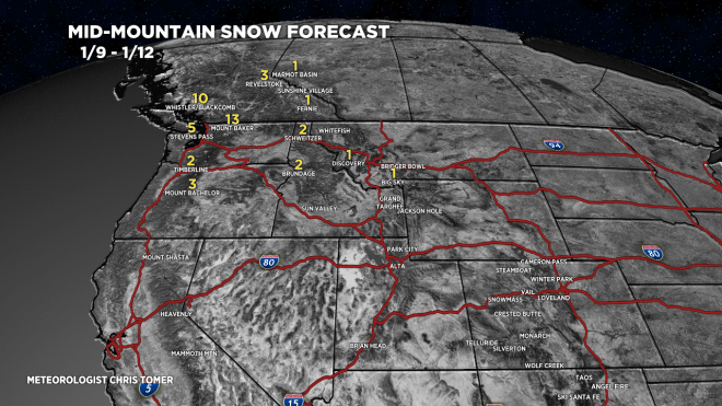
1/9-1/12: Notice the big drop-off in snowfall as higher pressures build.
Let’s drill down, here’s my snow forecast

Cameron Pass, CO:

For more analysis please watch my forecast video:
thx for posting for the Cameron Pass area, my go-to ski.
You bet, thanks, Judi! Chris