Tomer’s Take: El Nino has arrived. The triple-dip La Nina is over. Bottom line, El Nino is here through Winter 2024.
The La Nina for a generation
The 2022-2023 La Nina delivered big time to CA, UT, and CO. In fact, it overdelivered. It overperformed in ways not seen in historical records. It was a La Nina for the generations. We saw a roughly 20-day atmospheric river (AR) nail the Sierra and Interior Rockies. A mega-March delivered record amounts of snow/snow-water-equivalent to UT.
La Nina/El Nino are just patterns. They are not comprehensive. They help guide the forecast but there’s always room for change.
Notables
Season Totals:
Mammoth Base: 715″ (all-time record).
Palisades Tahoe: 723″ (all-time record).
Alta, UT: 903″ (all-time record). <–That’s 73 Feet
Brighton, UT: 878″ (all-time record).
Solitude, UT: 816″ (all-time record).
Latest Forecast
The red bars indicate El Nino. Bottom line, it’s here to stay through Winter 2024.

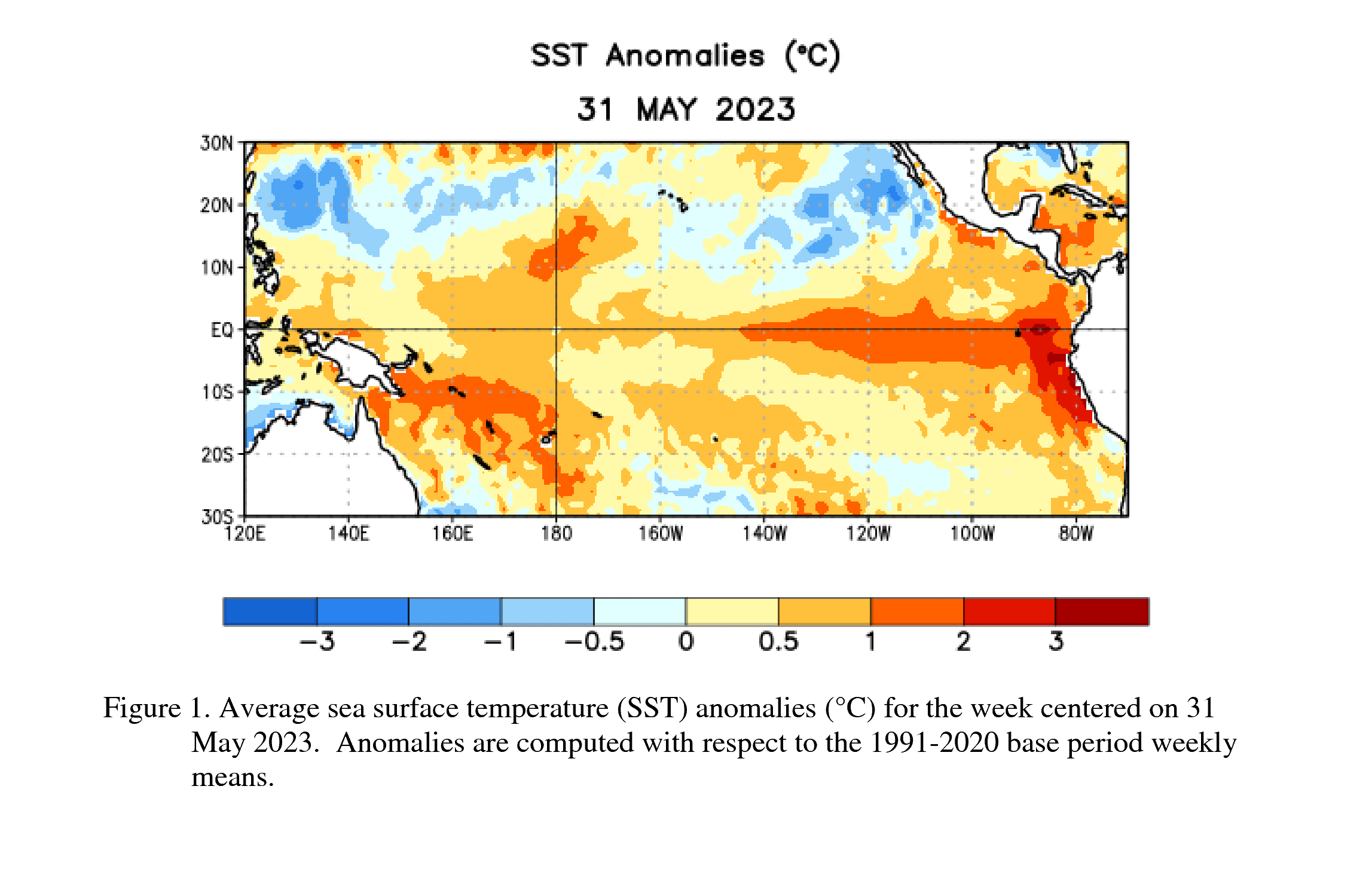
Current Sea Surface Temperature Anomalies
Red indicates warmer than normal sea surface temps. El Nino is characterized by warmer than normal water in the South Pacific near the Equator.

Where we’ve been
The blue represents La Nina; red is El Nino. We’re currently exiting from a triple-dip La Nina (3 straight Winter Seasons).

A zoomed-in version more recently:

Last two year’s of model forecasts: Below the black line equals La Nina (colder water temps). Now we’re headed up to warmer water temps (El Nino).

Current Model Forecast Spread
Most major Global models indicate El Nino is coming. Some indicate a ‘Strong El Nino’. +0.5C is the threshold for El Nino.

Forecast: El Nino and Severe Weather
El Nino tends to decrease hail and tornado risk while La Nina tends to increase the risk. A neutral phase can fall right in the middle with regard to risk.

Forecast: El Nino and Indian Monsoon
This is from older data but still applicable. El Nino tends to disrupt the Indian Monsoon.

Forecast: North American Monsoon
The data is more subtle for the Southwestern United States.
La Nina might lead to above average July-August precipitation.
El Nino might lead to below average July-August precipitation.

Typical El Nino Impact Pattern
We’re already seeing this abnormally strong Subtropical Jet. It’s why parts of the West have been so wet the last 1.5 months. In fact, record amounts of rainfall have occurred in Colorado.
Will this pattern persist into Winter 2024? Yes, in all likelihood.

Graphic courtesy NOAA.
What about Colorado Winter 2024?
The pattern above is likely, but I’ll drill-down more by mountain zone in the coming weeks.
Chris, Alta had 903″, Solitude had 816″, Brighton had 878″, Palisades Tahoe at 723″, Mammoth 715″. All clearly stated on their websites.
Thanks!
Updated my numbers per your message. Chris
I’m curious if ElNino would pact wind here in East Idaho with the change of the jet pattern. The last three years we have seen abnormally high winds all year. However, the last six weeks here something has changed and it’s been so nice with light winds almost every day, but we have had consistent afternoon thunderstorms.
Hi Creg, in theory you should see a decrease in wind with the southern jet playing a bigger role. Chris
Can you speak to how this might impact the 2023 summer months for backpackers planning long distance hikes in Colorado. Does the pattern indicate a lesser monsoon season with typical afternoon storms, possibly with less severe storms and faster moving?
Hi Debbie, it’s weak data but it does point to possible disruption of the July-August Monsoon. I’m not putting a lot of stock in it. But, might see a slightly drier than normal Monsoon season. Chris