Snow forecast through 3/30

Tomer’s Take: Two storm systems deliver heavy snow accumulation through 3/30. Snow bullseyes in UT, WY, CO.

Season Snow Totals so far:
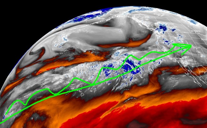
Current Setup

Infrared satellite shows the storm track and storm systems lined-up.

Forecast Pattern

Forecast jet stream valid 3/30. Notice the trough across the West and area of low pressure traversing CA.

Telluride, CO

3/21: 4-6″

3/22: 6″

3/23: 1″

3/24: 3″

3/25: 2″

3/26: 4″

3/27: 1-2″

Forecast Totals

3/21-3/23:

3/24-3/30:

3/21-3/30:

VT/NH/ME key dates:

3/25: 4-6″

3/26: 2-3″

3/27: 3″

3/28: 6″

Pattern through end of March

Tomer’s Take: Heavy snow continues out West through 3/26. Then, snow productions slows after 3/26.

Brighton, UT officially hit 703″ overnight making them the first resort to crack 700 inches.

Current Setup

Infrared satellite shows the current storm track with next storm cycle inbound.

Forecast Pattern

Forecast jet stream valid 3/29. A nearly cut-off low slides slowly through CA.

Forecast Timing

Forecast radar/satellite valid 3/20-3/25.

Crested Butte, CO

3/20: 6-8″

3/21: 10-12″

3/22: 6-10″

3/23: 1″

3/24: 2-4″

3/25: 2″

3/26: 2″

3/29: 2″

Forecast Tahoe Rain/Snow Line

3/20: 6600′

3/21: 5600′

3/22: 6400′

3/23: 6100′

3/24: 6100′

Forecast Totals

3/20-3/22:

3/23-3/29:

3/20-3/29:

Key snow dates through 3/27

Tomer’s Take: A series of storm systems ride an active jet across the West through 3/27.

My forecast video 3/18:

Key Forecast Snow Dates

Sierra: Afternoon 3/19-3/22 with a couple feet of grand total accumulation.

Wasatch: Late 3/19 through 3/25 with 2-3 feet of grand total accumulation.

Teton: 3/20-3/25 with two feet of grand total accumulation.

San Juan Mountains, CO: 3/20-3/23 with 2-3 feet of grand total accumulation.

New Mexico: 3/20-3/22 with 1-2 feet of grand total accumulation.

Forecast Tahoe Rain/Snow Line

3/19: 7900′

3/20: 6700′

3/21: 6700′

3/22: 5600′

3/23: 5700′

Forecast Pattern

Forecast jet stream valid 3/25. Notice the large trough across the West supporting unsettled weather.

Forecast Timing

Forecast radar/satellite valid 3/18-3/23.

Forecast Totals

3/18-3/20:

3/21-3/27:

3/18-3/27:

Snow forecast through 3/26

Tomer’s Take: 2-3 different storm systems are possible through 3/26 across the West. The snow bullseyes are CA, UT, AZ, NM, and CO with feet of accumulation.

Current Setup

Water vapor satellite shows the next storm cycle loading-up over the Pacific.

Forecast Tahoe Rain/Snow Line

3/19: 7400′

3/20: 5700′

3/21: 5600′

3/22: 5900′

Forecast Pattern

Forecast jet stream valid 3/25. Notice the big trough over the West keeping the pattern unsettled for the Mountains.

Forecast Timing

Forecast radar/satellite valid 3/17-3/22.

Wolf Creek, CO

3/17: 2″

3/18: 1″

3/20: Late 6-8″

3/21: 18″

3/22: 18″

3/23: 1″

3/25: 6″

3/26: 6″

Taos, NM

3/17: 3″

3/18: 1″

3/20: Late 4″

3/21: 12″

3/22: 12″

3/25: 2″

3/26: 2″

Forecast Totals

3/17-3/19:

3/20-3/26:

3/17-3/26:

VT/NH/ME bulk of snow occurs 3/23-3/25.

Pattern through end of March

Tomer’s Take: Pattern remains active for parts of the West through the end of March. Steady snow accumulation is likely in the Sierra 3/19-3/25 then the pattern shifts north favoring the Pacific Northwest and Northern Tier of States.

Season Totals So Far:

Mammoth’s All-Time Record at the Main Lodge (Base) is 668″ set in 2010-2011. Summit total is currently 778″.

Forecast Pattern

Forecast jet stream valid 3/25. An area of low pressure slides through the Intermountain West.

Forecast Timing

Forecast radar/satellite valid 3/16-3/21.

End of March Pattern

Forecast mid-atmosphere pressure anomalies valid 3/30. Overall pattern favors the PNW/Northern Tier of states for unsettled weather.

Forecast Tahoe Rain/Snow Line

3/19: 7200′

3/20: 7100′

3/21: 5800′

Forecast Totals

3/16-3/18:

3/19-3/25:

3/16-3/25:

Two storm systems through 3/24

Tomer’s Take: Two storm systems are likely across the West through 3/24. The snow bullseyes are CA, AZ, UT, NM, and CO. Snow levels start high on 3/15 then gradually fall. The PNW and Northern Tier are largely out of the storm track with lighter accumulation.

Forecast Wasatch Rain/Snow Line

3/15: 7600′ early, 6500′ afternoon

Forecast Pattern

Forecast jet stream valid 3/21. Notice the trough and gathering storm system over CA.

Forecast Timing

Forecast radar/satellite valid 3/15-3/20.

Forecast Totals

3/15-3/17:

3/18-3/24:

3/16-3/24:

Three storm systems through 3/23

Tomer’s Take: Three storm systems are likely across the West through 3/23. The last significant AR surge continues today then fades. In the Northeast, heavy snow continues today with another strong storm system possible 3/22-3/23.

Forecast Tahoe Rain/Snow Line

3/14: Up to 7900′

3/15: Up to 6600′

Current Setup

Water vapor satellite shows the Pineapple Express entrenched. Red/orange = drier air aloft.

Forecast Pattern

Forecast jet stream valid 3/21. This is the 3rd storm system of the period.

Forecast Timing

Forecast radar/satellite valid 3/14-3/19.

Alta, UT

3/14: Late 5″

3/15: 10″

3/18: 1″

3/21: 20″

3/22: 3″

Forecast Totals

3/14-3/16:

3/17-3/23:

3/14-3/23:

VT/NH/ME Key Snow Dates:

3/14: 11-12″+

3/15: AM 2″

3/17: 2″

3/22: 8″

3/23: 6″

Next Atmospheric River Surge 3/14; Another 3/21

Tomer’s Take: The next atmospheric river (AR) surge hits CA late 3/13 through early 3/15. Watching for one additional AR surge on 3/21. The Northeast gets moderate to heavy snow late 3/13 through early 3/15.

Forecast Tahoe Rain/Snow Line

3/13: Up to 7400′

3/14: Up to 8500′

3/15: Up to 6400′

3/16: Up to 7100′

3/17: Up to 6900′

3/18: Up to 6700′

Current Setup

Water vapor satellite shows the Pineapple Express in full swing.

Forecast Pattern

Forecast jet stream valid 3/19. The jet could be setting up for one more atmospheric river surge around 3/21

Forecast Timing

Forecast radar/satellite valid 3/13-3/18.

Snowmass, CO

3/13: 1″

3/15: 3-6″

3/16: 6″

3/19: 1″

3/20: 1″

3/21: 1″

3/22: 5-10″

Forecast Timing

3/13-3/15:

3/16-3/22:

3/13-3/22:

VT/NH/ME Key Snow Dates:

3/13: Late 2″

3/14: 15″+

3/15: 1″

3/17: 1″

3/18: 2″

Snow forecast through 3/21

Tomer’s Take: High rain/snow line continues in CA. Next atmospheric river (AR) surge arrives late 3/13-3/15. Looking down the road, another storm system hits the West 3/19-3/21 with colder air.

My mountain weather forecast video 3/12:

Forecast Tahoe Rain/Snow Line

3/12: Up to 7100′

3/13: Up to 7400′

3/14: Up to 8400′

3/15: Up to 6700′

Forecast Pattern

Forecast jet stream valid 3/19. Strong jet streak over the Pacific escorting next storm system into the West.

Forecast Timing

Forecast radar/satellite valid 3/12-3/17:

Forecast Totals

3/12-3/14:

3/15-3/21:

3/13-3/21:

Main storm system hits late 3/13 through early 3/15. Light snow on 3/18.

AR Surge 3/14 and Storm System 3/19

Tomer’s Take: Active jet pattern continues out West with another atmospheric river (AR) surge coming late 3/13 through early 3/15. This is followed by a storm system on 3/18-3/20. The Northeast could see two storm systems.

My mountain weather forecast video 3/11:

Current Setup

Water vapor satellite shows the Pineapple Express in full swing.

Forecast Lake Tahoe Rain/Snow Level

3/11: Up to 7200′

3/12: Up to 7100′

3/13: Up to 7200′

3/14: Up to 7900′

3/15: Up to 7100′

3/16: Up to 9200′

Forecast Pattern

Forecast jet stream valid 3/19. Notice the active West-to-East flow escorting storm systems inland.

Forecast Timing

Forecast radar/satellite valid 3/11-3/16.

Forecast Totals

3/11-3/13:

3/14-3/20:

3/11-3/20:

3/11-3/20:

3/11-3/20:

VT/NH/ME Key Snow Dates:

3/11: 1″

3/13: Late 1″

3/14: 10″

3/15: 1″

3/18: 6″