Tomer’s Take:
- A large Western ridge of high pressure remains in control through 10/22.
- A pattern change is possible on/after 10/23.
- A large dip in the jet stream and lower atmospheric pressures might replace the large Western high pressure ridge.
- This pattern change might run 10/23-10/27.
- Net result: snow and colder temps for UT, CO, WY, MT, ID, Banff, and the PNW.
- The strongest La Nina since 2010 remains in control.
Current Setup
You’re looking at the key to the potential pattern change on 10/23. Notice the trio of low pressure systems. They will set the stage for the weakening/dislodging of the big Western high. They will not act alone.

Current mid-atmosphere pressure pattern:

Loveland Ski Area started making snow Wednesday morning 10/12/2022.
Parker the Snow Dog was there supervising:

Arapahoe Basin also started making snow. See their update here.
Alta, Utah October 2021
- October generated 67″ of total snow.
- Average October snowfall is 28.5″.
- Snow started falling after October 7, 2021.
The view at Alta on October 13, 2021 with 14″ storm totals:

La Nina Holding Strong
The latest (10/6/2022) Multivariate ENSO Index continues to indicate the strongest La Nina since 2010 at -1.8. This is a triple-dip La Nina.
This has created three straight Fall Seasons with abnormally warm and dry conditions across the West.

MEI historical values:

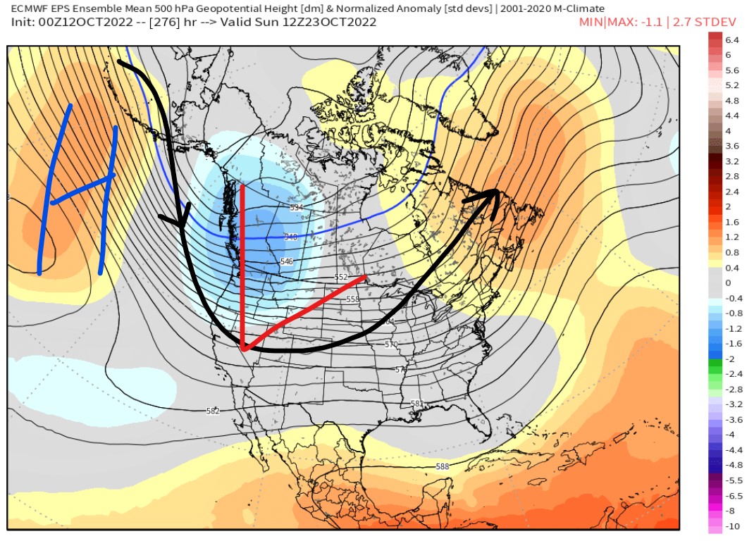
Pattern Change
10/23 forecast mid-atmosphere pressure pattern:

Some data suggest snow and colder temperatures across the West if this pattern change occurs.
The Global Forecast System is optimistic 10/23-10/27.

The Pacific North American (PNA) pattern also shows this pattern change. It turns sharply negative on/after 10/23 through 10/27.
A negative PNA suggest lower pressures across the Western US.

Well here is hoping ❄️ , Up in the Banff area it’s like the entire year has always been a month late every month since June 😬
Fingers crossed, Jim!
Good report Chris.
Thanks, Tim!