Tomer’s Take: Snow and colder air is pivoting south across the West. Big totals continue. A quiet period emerges 2/1-2/4.
Jackson Hole, WY is reporting 27 inches in the last 24 hours. That’s 42 inches in 48 hours!
Steamboat, CO is reporting 10 inches in the last 24 hours. That’s 18 inches in 48 hours!
Alta, UT is reporting 13 inches in the last 24 hours.
My forecast video 1/28:
Current Setup
Water vapor satellite shows the big trough across the West as the pattern pivots and the high retrogrades.

Forecast Pattern
Forecast jet stream valid 2/6. Notice the trough across the Rockies.
Quiet period Rockies: 2/1-2/4.
Active period Rockies: 2/5-

Mount Baker
A slug of moisture hits Baker 2/3-2/6.
2/3: 9″
2/4: 12″
2/5: 12″
2/6: 6″
Forecast Timing
Forecast radar/satellite valid 1/28-2/2.
Forecast Totals
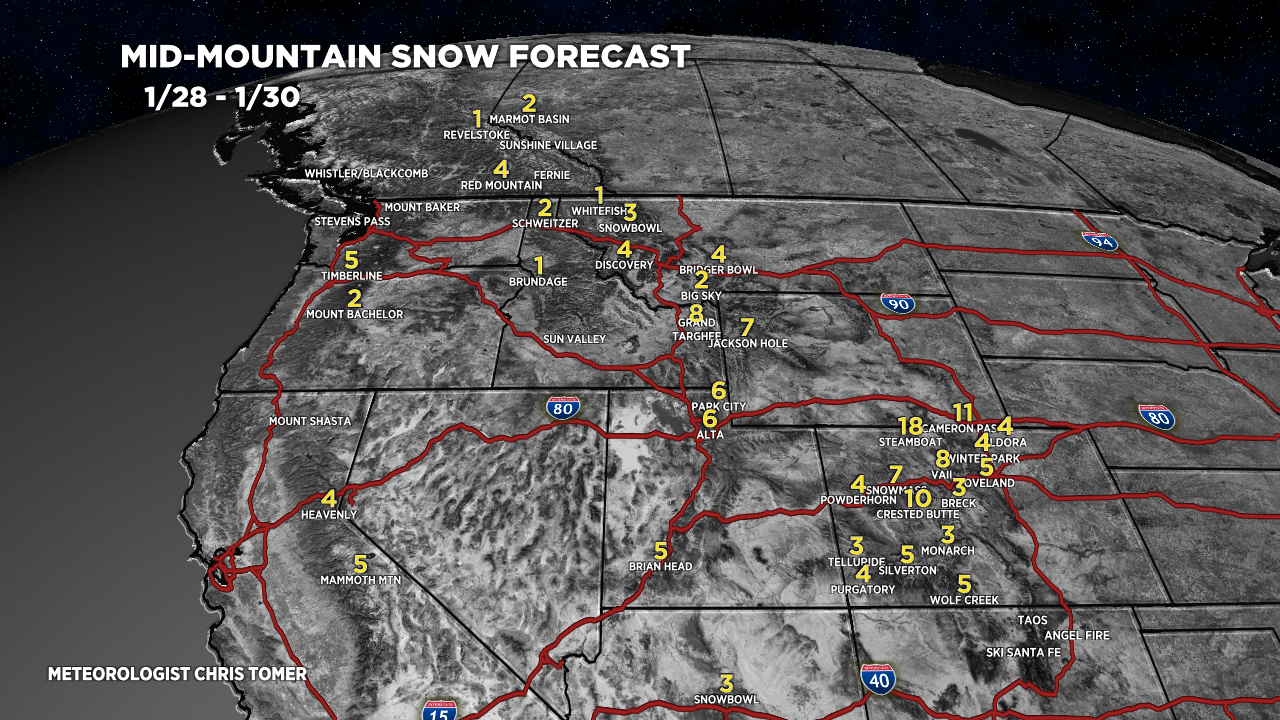
Forecast snow totals (inches) valid 1/28-1/30.

Forecast snow totals (inches) valid 1/31-2/6.

Forecast C+N CO snow totals (inches) valid 1/28-2/6.

Forecast C+N CO snow totals (inches) valid 1/28-2/6.
The grand totals for Southern Colorado continue trending down.

Forecast snow totals (inches) valid 1/28-2/6.

Chris,
Greetings from the mid-west. Perfect North was a big bust this week. They were calling for 3-5″ but the rain/snow line busted along the Ohio River valley leaving just rain for the OH-KY-IN tri-state. It did snow about 4″-5″ by Mt. Rumpke but that is mosty trashy (it’s really trash!) orographic snow. Other wise I had a great trip out west Jan 3-12. Caught 11″ at WC, the 1st two days of the T-bars at CB, then a few soft days at Key. Finished it off with a 6″ pow day at Monarch.
Your predictions allowed me to choose wisely and was rewarded handsomely. Much appreciated with the Blog and U-Tube. That’s why you are the MVM! MOST VALUABLE METEOROLOGIST!
Thanks, Randall!