Tomer’s Take: May and now June are wetter than normal across parts of the West. I’m forecasting wetter than normal conditions through June 15 then the pattern gradually returns to ‘normal’ precipitation late June. The effects are more pronounced June 20-30 just before the seasonal Monsoon.
Precipitation Last 30 Days
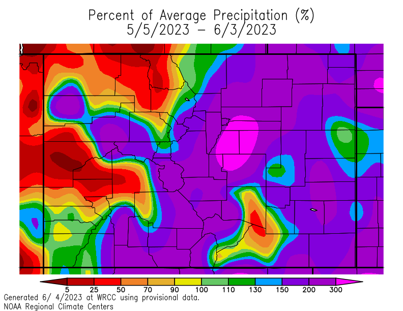
Percentage of average valid 5/5-6/3: The areas in blue and purple represent 150-400% of average precipitation.

Take a closer look at Colorado: Most of the Divide and East are 150-300%+ of average. Soaked.

Drought Impact
All this precipitation (rain+snow) has significantly reduced the Western Drought. Look at this before (December 27, 2022) versus after (Current Day) slider:


Why is this happening?
We’re making a hard transition from three straight years of La Nina (‘Triple-Dip’) into El Nino. I believe this is contributing to an abnormally powerful SubTropical Jet Stream. It opens the door for precipitation transport into the Western United States. Notice below it acts like conveyor belt ushering in areas of low pressure.

Forecast: Precipitation Through June 15
Valid through 6/18 from the Climate Forecast System. Notice the blue bullseye over most of the West. That equates to 150-400% of normal total precipitation. This is not normal for June.

Forecast: Late June
Valid 6/18-6/28 from the Climate Forecast System. Notice the blue bullseye is gone and is replaced by light to dark green colors. Ultimately this means less precipitation but not totally dry. This is a return to more ‘normal’ conditions.

Summary
- Wetter than normal forecast early to mid June.
- Drier with normal precipitation late June.
- Seasonal Monsoon normally engages July-August.
Looking forward to less rain!
Thanks, Judi!
What a wonderful break from the drought!
Yes! Thanks, Dave.