Tomer’s Take:
- Two storm systems are lined-up 11/1-11/8 for the West.
- Storm #1 takes a deep southern track 11/1-11/4 favoring southern tier of the Rockies.
- Storm #2 takes a northern track 11/5-11/8 favoring northern tier of the Rockies. I like the way this pattern looks at this time. Big snow totals are possible.
Current Setup
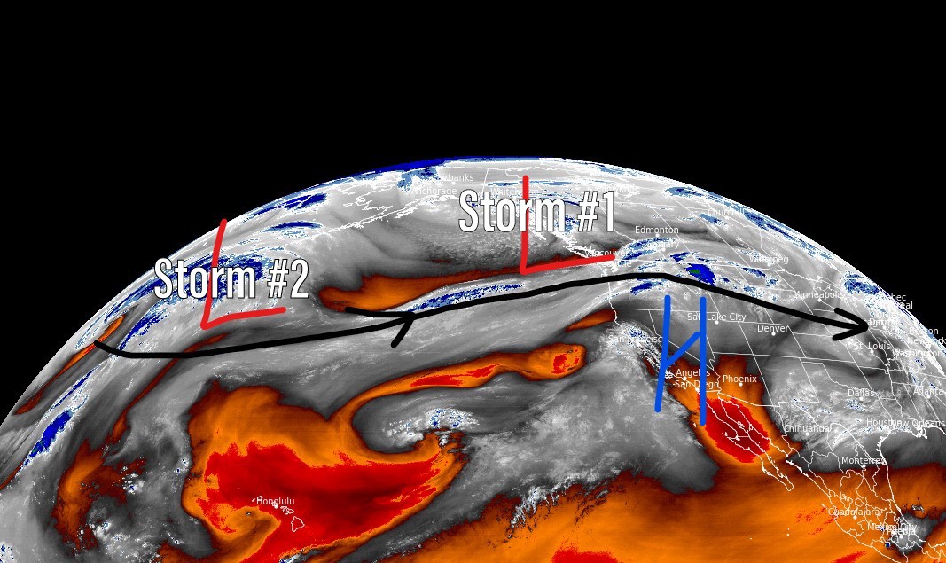
Water vapor satellite shows the storm track and two storm systems lined-up over the north Pacific. The first low pressure dislodges the high pressure between 11/1-11/4, drops south through California, then takes a deep southern track. Orange/red = drier air aloft.

Storm #1
10/31-11/4. Forecast jet stream flow reveals important characteristics affecting California snowfall. The trough is positive tilt, it’s fast, and orographics are not optimal.

Forecast jet stream flow valid 11/4/2022. The low takes a deep southern track favoring southern UT, southern CO. The flow is not optimal for northern NM.

Storm #2
11/5-11/8. Forecast jet stream flow valid 11/5/2022. I like the way this looks. The 2nd storm system might be the winner. As storm #1 moves east, the residual jet flow reloads with a jet streak. And, most importantly the orientation is WNW. This could deliver big totals to the northern tier of the Intermountain West.

Forecast Timing
Forecast radar/satellite valid 10/31-11/5.
Forecast Snowfall
Forecast snow totals (inches) between 10/31-11/4.

Forecast snow totals (inches) between 11/5-11/8.

My forecast video 10/31.