Tomer’s Take: The primary ABQ low is moving east. Next up is a snails-pace low in CA nailing the Sierra. This low will sit and spin for a few more days before ejecting into the Southern Tier with snow. Behind it is a 2nd low pressure with wind and snow for the Sierra and the West. 50-100 inch grand totals for the Sierra by 3/4.
104mph gust on Kendall Mountain, CO on 2/22. Wind gusts continue to hover around 100mph on 2/23. Air temps are below zero making the wind chills dangerous.
102mph gust on Wolf Creek Pass, CO on 2/22, early 2/23. Strong wind and below zero air temps continue on 2/23.
Current Setup
Water vapor satellite shows the departing ABQ low and snails-pace low in CA.

Forecast Pattern
Forecast jet stream valid 3/1. A strong storm system ejects out of CA and runs across the Intermountain West with wind and snow.

Ruby Mountains
By request…
3/1: 8″
3/2: Flurries, 30-40mph gusts
3/3: 4″, 30-40mph gusts
3/4: Flurries, 30-40mph gusts
3/5: Flurries, 40-50mph gusts
Mammoth Mountain
2/23: 4″
2/24: 28″
2/25: 10″
2/26: 2″
2/27: 12″
2/28: 22″
3/1: 12″
3/4: 2″
Telluride, CO
2/23: 3″
2/24: 6″
2/25: 0″
2/26: 4″
2/27: 1″
2/28: 1″
3/1: 8″
3/2: 5″
3/3: 0″
3/4: 3″
Forecast Totals
2/23-2/25:

2/26-3/4:

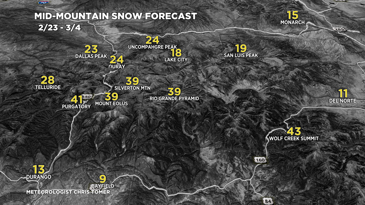
2/23-3/4:

2/23-3/4:
VT/NH/ME snow dates:
2/23: 4″
2/24: 1″
2/25: 0″
2/26: 1″
2/27: 0″
2/28: 8″
3/1: 2″
3/2: 0″
3/3: 4″
3/4: 5″

I liked that you included the Ruby Mnts today, lots of great memories there, great place to camp and hike. Thanks for your great work, Chris!
Thanks, Doug!