Tomer’s Take: The Western blizzard turns into a large snowstorm for the Northeast 12/16-12/17. Out West, the pattern settles down with only light snow accumulation through 12/19 then turns more active 12/20-12/22+ as two Pacific storms catch a fast northern branch.
- Alta, UT is reporting 50″ between 12/10-12/14.
- Winter Park, CO is reporting 10″ in 48 hours.
- Aspen Mountain, CO is reporting 15″ in 48 hours.
- Wolf Creek, CO is reporting 13″ in 48 hours.
- Buffalo Pass, CO about 24″ between 12/10-12/14 (1.6″ SWE).
- Avalanche Warnings are in effect for parts of Colorado’s mountains. Ingredients include a foot or more of new snow (in the last 4 days) plus consistent 30-70mph wind gusts and both a persistent slab and storm slab risk.
My forecast video 12/14:
Current Setup
Water vapor satellite shows the Western blizzard slowly working its way through the Dakotas. Its destination is the Northeast.
You’ll also notice two low pressure’s in the Pacific. The southern low is cut-off from the northern branch but might get picked up 12/20-12/22 by a Canadian cold front/trough. The 2nd low might also get picked up around 12/22 or later.

Forecast Pattern
Forecast jet stream valid 12/15/2022.

Forecast jet stream valid 12/22/2022.
The two low pressure systems in the Pacific might get picked up by the Northern Branch and escorted into the West Coast.
Out East, a large dip in the jet dominates the pattern supporting additional snow.

Northeast
Forecast jet stream valid 12/16/2022.
Notice the powerful jet stream escorting the Western blizzard into the Northeast.

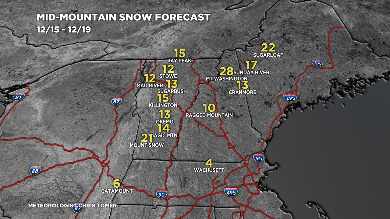
Forecast snow totals (inches) valid 12/15-12/19. Most of the big resorts get a foot or more.

Forecast Timing
Forecast radar/satellite valid 12/14-12/19.
Forecast Totals
Forecast snow totals (inches) valid 12/14-12/16.

Forecast snow totals (inches) valid 12/17-12/22.

Thanks Chris for update!! Storm was real bust for Summit County and divide ski areas. We need at least a few more dumpers but don’t see any in sight. Time to chase in ID, MT and WY!!
Thanks, CW! Maybe we’ll see a better pattern for Summit County on/after 12/21. Chris
Thanks, Chris! We’ve had 25 inches here in Steamboat over the last few days and it was snowing steadily all morning. Just finally stopped for a while. It’s the fluffy champagne stuff too.
Outstanding, Kristin! Chris
Thanks for the updates Chris! Your weather reports are awesome. I’m headed to Whitefish this Sunday. Will be a challenge to get there for sure.
Sounds like fun, David! Looks snowy and colder in Whitefish…enjoy! Chris
Hey Chris – super informative blog. Getting ready for our Christmas trip to Telluride. Could sure use some southern track snow for our time out there. 🙂
Thanks, Shawn! Wish I had a southern track storm for you. Don’t see it at this point but it’s still 10 days out. Chris
Hey Chris Im going to mammoth on the 22nd do you think it will be snowing?
Hi Isaac, at this point it doesn’t look like it but let’s see if the pattern changes. Chris