Tomer’s Take: Storm #1 continues to drop heavy snow accumulation and strong wind gusts. Storm #2 delivers heavy snow 12/3-12/7 in many of the same locations.
Overall, I decreased many of my forecast totals after observing how storm #1 unfolded. Some forecast totals in CO increase.
- An additional storm system arrives 12/8-12/10.
Snow accumulation continues across WY, UT, CO. Overall totals were on-target in the Tetons but lighter than expected in the Wasatch. Totals in the Sierra were also lighter than expected where the sun is now out waiting on the next storm system. Colorado, is extremely windy with 100mph gusts hammering the snowpack.
The view at Loveland Ski Area with low visibility and blowing snow:

The view from Mammoth Mountain, CA after about two feet of new snow.

Current Setup
Infrared satellite shows storm #2 and storm #3 lined-up with a powerful jet stream.

Forecast Pattern
Forecast jet stream valid 12/3/2022. Storm #2 is on the doorstep of CA.

Forecast jet stream valid 12/6/2022. Pattern remains active.

Forecast jet stream valid 12/11/2022. The pattern has shifted. High pressure rebuilds and jet moves north.

Forecast Timing
Forecast radar/satellite valid 12/2-12/7.
Forecast Totals
Forecast snow totals (inches) valid 12/2-12/3.

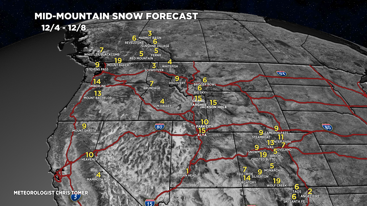
Forecast snow totals valid 12/4-12/8.
Overall, I decreased many of my forecast totals after observing how storm #1 unfolded. I increased my forecast totals for a few locations in Colorado.

My forecast video 12/2:
I was hopeful for a pretty big punch from this last storm but it held more wind than moisture. Hopefully here is East Idaho/Western WY, the Sunday/Monday storm is better!
I hear you, Creg. Looks like the Tetons get the most 12/4-12/5 in that region. Down the road, bigger totals are possible 12/8-12/12. Chris
Thanks for “reallocating” some of that snow to Red Mountain Pass!
😉 Should be a good stretch through 12/12 for parts of Colorado. Thinking 8-14″ over Red Mountain by 12/12.