Tomer’s Take: A panhandle hooker storm system continues to slide through CO/NM then it becomes a Northeast storm system. The Western pattern then shifts. The jet moves north and higher pressures build across the Pacific and West Coast. Two additional storm systems might deliver big totals to the Northeast on 1/22-1/23 and 1/24-1/25.
Wolf Creek, CO is reporting another 16 inches in 24 hours and 52 inches in 4 days.

A note on Mammoth Mountain. Their season total measured at the Main Lodge is 378″ with of course more at the summit.
My forecast video 1/18:
Current Setup

Forecast Pattern
Forecast jet stream valid 1/27. Notice the high pressure ridge over CA and parts of the Pacific. The storm track runs into the PNW, BC, MT, WY, CO.

Early February Pattern
Below is the EPS forecast atmospheric pressure anomalies (mid atmosphere) valid 2/1/2023.
The pattern continues to favor the West/PNW/Northern tier for snow and cold.

Forecast Timing
Forecast radar/satellite valid 1/18-1/23.
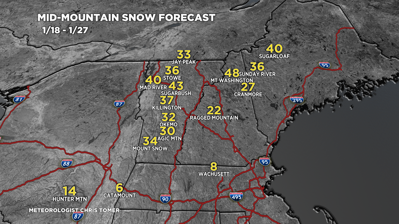
Forecast Totals
Forecast snow totals (inches) valid 1/18-1/20.

Forecast snow totals (inches) valid 1/21-1/27.

Forecast snow totals (inches) valid 1/18-1/27. Three total storm systems possible. 1) 1/19-1/20, 2) 1/22-1/23, 3) 1/24-1/25.

Thanks,Chris!! Very good and detailed report!?
Thanks, Judith!
Very good reporting!!
I’ve been reading snow forecasts for 20+ years and yours is the best I’ve read. Thanks for the succinct and detailed information! Much appreciated!
Thanks so much, KM! Chris
Hey Chris, thank you so much for all you do for the skiing community! You have reignited my fire to chase storms!
My work just relocated me to Atlanta Georgia. So, yay for mountain biking but, boo for skiing..
I did some research and Snowshoe Mountain in WV seems to have some decent elevation and pretty good man-made snow equipment. But do they ever get actual snow? Could you include it in your forecast if you see something on its way there?
Thank you!!!
Thanks, Jamie! I’ll put Snowshoe on my list. I don’t normally follow their progress but will take a look. Chris