Tomer’s Take: A three storm combo remains in my forecast through 12/12 with heavy grand totals across the West. A forth storm system is possible on 12/13-12/14.
- Storm #1 is moving at snails pace and continues pushing snow into the Sierra and also interior Rockies of UT, WY, and CO through 12/7.
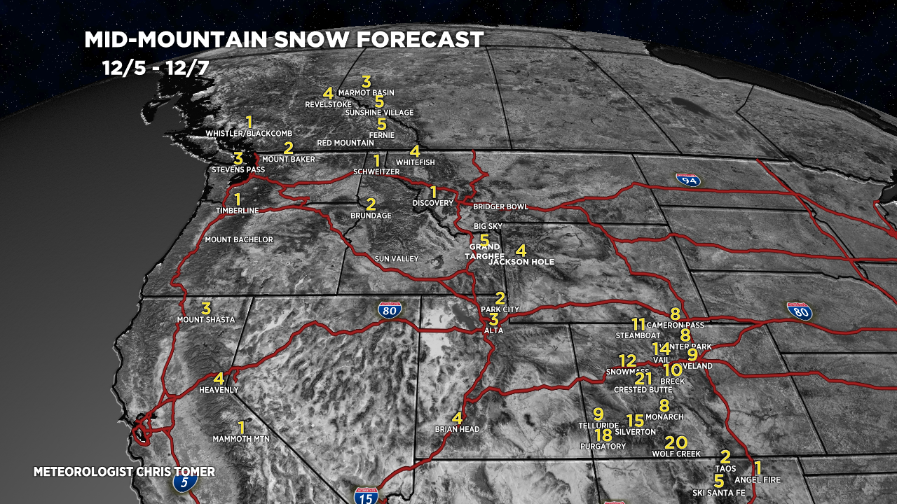
- Storm #1 has a few bullseyes in the Colorado including Crested Butte, Vail, Steamboat, Wolf Creek, Silverton, and Purgatory.
- Storm #2 12/8-12/9 is trending weaker especially for CA, UT, WY, CO.
- Storm #3 12/10-12/12 is stronger and colder.
- Alta and Snowbird are reporting 8-9 inches in the last 24 hours. Jackson Hole is reporting 6 inches in the last 24 hours.
- Mammoth Mountain is reporting 5.5 feet of snow so far this December.
Snow is also falling in Colorado where it’s just getting started. A 3.5 day prolonged period of focused snow is in my forecast with over a foot for a few locations.
Loveland’s view is shrouded this morning:

Current Setup
Infrared satellite shows the storm systems lined-up in the Pacific. Storm #1 is very slow moving in a deep trough.

Forecast Pattern
Forecast jet stream valid 12/6/2022. Very slow moving low pressure in a deep trough.

Forecast Jet stream valid 12/13/2022. The storm track has shifted further north favoring the PNW, BC, Banff and northern tier of the Rockies. Potential storm #4 inbound.

Forecast Timing
Forecast radar/satellite valid 12/5-12/10.
Forecast Totals
Forecast snow totals (inches) valid 12/5-12/7. Notice the bullseyes in Colorado.

Forecast snow totals (inches) valid 12/8-12/13.
