Tomer’s Take: The atmospheric river now looks to continue through 1/8. Feet of additional snow accumulation likely in CA, UT, WY, CO. But, the 2nd period appears to generate less snow for UT than previous updates.
My forecast video 12/30:
Current Setup
Infrared satellite shows the Pineapple Express and parade of low pressure systems lined-up through 1/8.

Forecast Pattern
Forecast jet stream valid 1/8. The west-to-east orientation continues to act like a conveyor belt for moisture transport into the Western United States.

Moab-Grand Canyon
Per request, here’s what I see for the Moab-Grand Canyon area January 1-7, 2022.
| Moab | GC | |
| 1/1 | 100% Rain, 47/38, Gusty | 100% Mix, 40/33, Gusty |
| 1/2 | 90% Mix, 38/32 | 50% Snow, 31/25 |
| 1/3 | 30% Snow, 34/29 | 90% Snow, 29/23 |
| 1/4 | 20% Snow, 34/26 | 30% Snow, 30/20 |
| 1/5 | 30% Snow, 35/26 | 40% Snow, 33/20 |
| 1/6 | 30% Snow, 36/29 | 30% Snow, 33/22 |
| 1/7 | 20% Snow, 34/27 | 20% Snow, 34/21 |
Forecast Timing
Forecast radar/satellite valid 12/30-1/3.
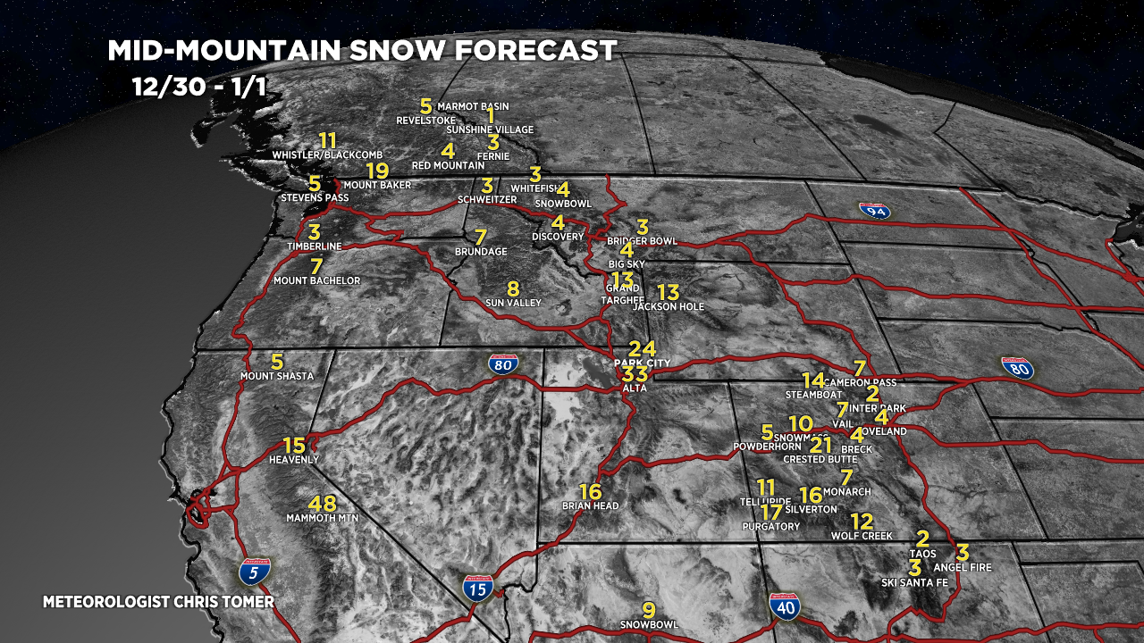
Forecast Totals
Forecast snow totals (inches) valid 12/30-1/1.

Forecast snow totals (inches) valid 1/2-1/8. The Wasatch totals for this period have decreased. A storm system on 1/5-1/6 is weaker after departing CA. And, a storm system on 1/7-1/8 also appears weaker after departing CA.

Period grand totals 12/30-1/8:
Mammoth Mountain, CA: 94″
Tahoe/Palisades/Kirkwood/Heavenly: 69″
Alta, UT: 45″
Jackson Hole, WY: 28″
Aspen/Snowmass, CO: 25″
Crested Butte, CO: 42″
Wolf Creek, CO: 38″
Steamboat, CO: 31″
My forecast snow timeline for the Wasatch:
- 12/30: 6″
- 12/31: 18″
- 1/1: 9″
- 1/2: 2″
- 1/3: 1″
- 1/4: 1″
- 1/5: 4″
- 1/6: 4″
- 1/7: 0″
- 1/8: 0″
Forecast snow totals (inches) valid 12/30-1/8.

Chris,
Thanks for Moab/GC – very helpful as always!
Don’t forget to send some love ($) to Tomer. Dude works his tail off.
Thanks, Randall! Happy New Year!
You bet, Rick!
Kirkwood was raining at the summit (cornice) today and the whole area was one sopping mess… hopefully, temps and snow line come down tmrw!
Great blog and quick hit YouTube vids! Thanks Chris!
Thanks, David! Chris
thanks ,Chris for your awesome reports!
Happy New Year, Judi!