Tomer’s Take: The atmospheric river (AR) continues through 1/16 then fades. The next two AR surges deliver feet of snow to the West.
Heavy snow continues in the Sierra through 1/10 with a moderate to strong AR surge. Snow levels run abnormally high on 1/9 then gradually fall. Mammoth Mountain is reporting 14-18 inches of new snow.

Kirkwood is reporting 11″ in the last 24 hours and 55 inches in the last 7 days.
Mount Rose is reporting 14-18″ storm total so far.

Current Setup
Infrared satellite shows a busy Pacific with 3 different storm systems lined-up and Pineapple Express.

Forecast Pattern
Forecast jet stream valid 1/18. The pattern shifts to a split jet. This is a very different pattern than during the heart of the AR.

Atmospheric River
Below is the ECMWF IVT 15-day forecast by latitude. Moisture transport fades after 1/16.

Forecast Timing
Forecast radar/satellite valid 1/9-1/14.
Forecast Totals
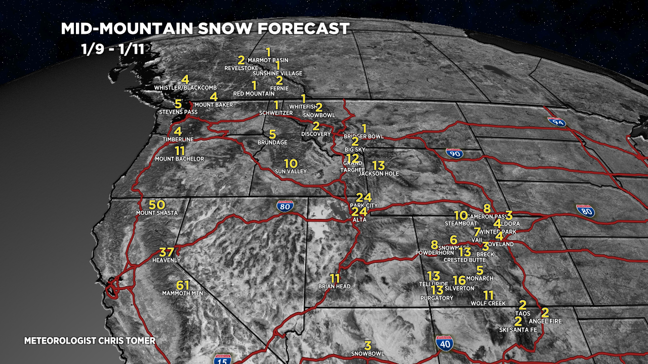
Forecast snow totals (inches) valid 1/9-1/11.

Forecast snow totals (inches) valid 1/12-1/18.

Forecast Grand Totals:
Mount Shasta: 80″
Heavenly: 70″
Mammoth: 84″
Alta, UT: 50″
Wolf Creek, CO: 27″
Steamboat, CO: 25″
Jackson Hole: 26″
Snow timeline for the Wasatch:
1/9: 6″
1/10: 12″
1/11: 6″
1/12: 0″
1/13: 0″
1/14: 1″
1/15: 10″
1/16: 6″
1/17: 6″
1/18: 4″
Forecast snow totals (inches) valid 1/9-1/18. Most of this snow occurs 1/12-1/15. Precipitation changes to rain on 1/13 then back to snow.
