Tomer’s Take: A monster storm system loaded with atmospheric river (AR) continues today in CA, WA, OR with 100mph wind and high snow levels. Part of that moisture then moves into the interior Rockies including NV, UT, ID, WY, and CO. There are three additional weak to moderate intensity AR surges through 1/14.
My afternoon video update 1/5:
It continues to snow very hard at Mammoth Mountain with more accumulation likely. 7am cam view:

Current Setup
Water vapor satellite shows the big low pressure system nailing the West Coast. It represents a moderate to strong AR surge. 100mph wind and high snow levels are present in the Sierra.
Orange/red = drier air aloft.

Atmospheric River
Below is the GEFS model IVT forecast by latitude. There are three additional weak to moderate AR surges through 1/14. The current storm system is the largest AR surge of them all – look at the brighter colors (pink/purple/red).

Forecast Pattern
Forecast jet stream valid 1/14.

Forecast Timing
Forecast radar/satellite valid 1/5-1/10.
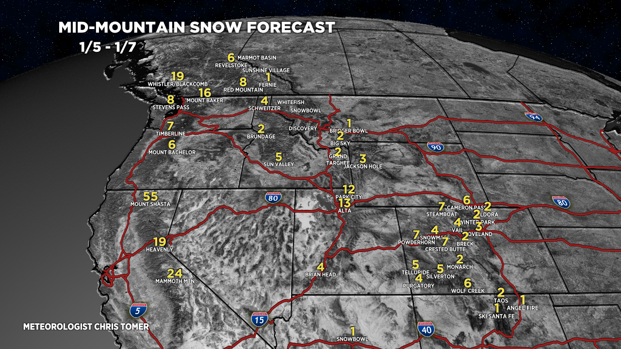
Forecast Totals
Forecast snow totals (inches) valid 1/5-1/7.

Forecast snow totals (inches) valid 1/8-1/14.

Forecast snow totals (inches) valid 1/5-1/14.

I was hearing that the temps in Cali will be too warm and ruin what would otherwise be a great snow event for them. Thoughts? Debating whether I should storm chase for it. Sounds like rain at the base of resorts and real wet/heavy snow
Snow levels are running abnormally high through 1/5 and will likely again for the 1/9-1/10 storm system.
Chris, thanks for clarifying what the different colors indicate. I look forward every day for you weather updates.
You bet, thanks, Jerry!