Tomer’s Take:
- Three different storm systems likely through 11/10.
- Storm #1 is currently sliding through UT, AZ, NM, and CO.
- Storm #2 is part of an Atmospheric River (AR) that nails the PNW/BC then potentially the Sierra.
- Storm #3 follows a similar track to Storm #2 and delivers another round of heavy snow to the Sierra and Intermountain West.
Last Day on Daybreak
When I’m not forecasting for mountaineers and skiers around the world, my primary job is forecasting weather on KDVR/KWGN-TV Daybreak morning show in Denver, CO. Today is my last day. I’ll still be at the station but my schedule will change. I’ve been getting up at 2:30am for over 10 years and it’s time to get some sleep. I’ll be joining a new show called Great Day Colorado (9-10am M-F) starting on January 3, 2023. I’ll be co-host with weather/lifestyle/interview responsibilities and part of a fantastic team. I’m grateful to the station for this new role!
I’ll continue with my mountain weather forecasts, this Blog, and my YouTube channel.

Current Setup
Water vapor satellite shows the active storm track and three storm systems riding the flow. Orange/red = drier air aloft.

Heavy snow is currently falling at Wolf Creek in Colorado. I’m forecasting over a foot of total snow accumulation by Friday morning.

Skies have cleared at Alta, UT after a foot or more of storm total accumulation. Additional snow accumulation is likely with Storm #2 & Storm #3.

This was the view in Park City, UT on Wednesday afternoon. Photo from Burton J. Kloster III.

November 3-10
Forecast jet flow valid 11/5/2022. This is Storm #2. Storm #3 is behind. Notice the W-E orientation of the jet stream pointed directly at the PNW/BC. This is technically a brief moderate-strong Atmospheric River (AR) setup. Heavy rain/snow likely.

Forecast jet flow valid 11/6/2022.

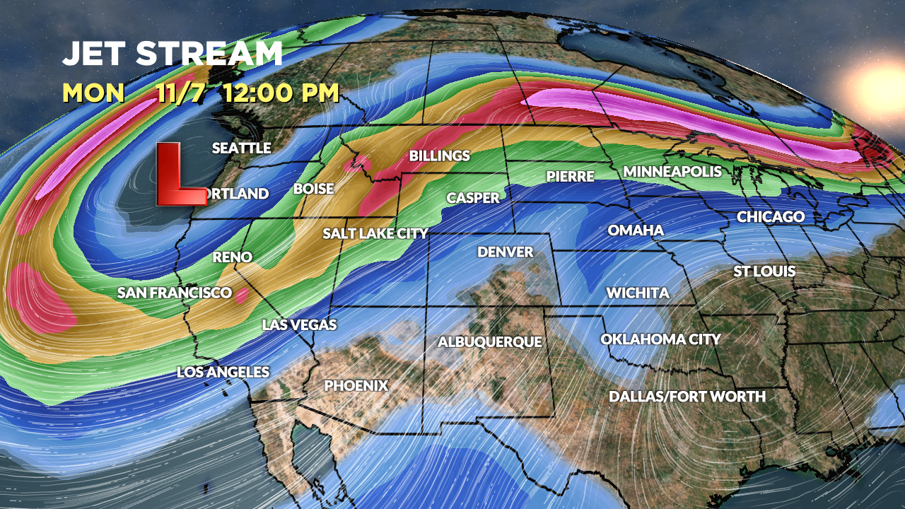
Forecast jet flow valid 11/7/2022. Notice the jet orientation with respect to the Sierra. Heavy snow possible. This might qualify as a weak AR.

Forecast Timing
Forecast radar/satellite valid 11/3-11/8.
Forecast Snowfall
Forecast snow totals (inches) valid 11/3-11/5.

Forecast snow totals (inches) valid 11/6-11/11.

My video forecast 11/3 with NEW updated snow totals 11/6-11/11:
Best wishes on your new job. I know you will do well. Congratulations on getting some sleep! I’m so glad you are continuing the blog and your channel. I rely on your forecasts!
Thanks, Robin! Chris
Hope you have a great last day. Thanks for all your hard work, it is greatly appreciated.
Thanks, GB! Chris
Never call last day 😜
I am so glad you will still be here for us! Good luck to you on your new adventure!
Thanks, Judi! I’ll continue with my mountain weather forecasts, blog, and YouTube channel. Chris
We’ve watched you all these years on Daybreak and will miss you! Thank you for your accurate weather reporting. We still remember and laugh about the April Fools joke where you pushed pregnant Vickie to the elevator, fooling us all that she was in labor🤣. Good luck!
Thanks, Sharon! Thanks for watching all these years. I’ll continue at the station just on a different schedule working Great Day Colorado 9-10am and other weather. I’ll continue doing my mountain weather forecasts, blog, and YouTube channel! Chris