Tomer’s Take: Feet of snow accumulation continues in CA with a moderate to strong intensity atmospheric river (AR) surge through 1/10. The next surge occurs 1/14-1/17. Snow from both AR’s hit UT, WY, ID, CO.
My afternoon mountain weather update video with new numbers:
Mammoth Mountain is reporting 31-46 inches of new snow. Additional snow accumulation likely today.

Current Setup
Infrared satellite shows the current storm system hitting CA and the final storm system lined-up in the Pacific for 1/14-1/17.

Forecast Pattern
Forecast jet stream valid 1/19. In the wake of the 10-15 day AR pattern we’re left with a split jet, which redirects storm systems to the PNW.

Atmospheric River
Below is the ECMWF IVT 15-day forecast by latitude. IVT continues until 1/17 then the flow dries up.

Forecast Timing
Forecast radar/satellite valid 1/10-1/15.
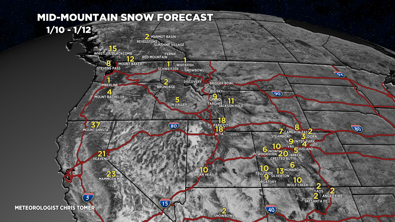
Forecast Totals
Forecast snow totals (inches) valid 1/10-1/12.

Forecast snow totals (inches) valid 1/13-1/19. The final AR surge delivers nice snow totals to the interior Rockies.

Forecast snow totals (inches) valid 1/10-1/19.

Anybody else scared that when this AR shuts off, we’re more or less done for the winter?
Yeah, I think once this ends, it may be dry for a while. The good news is that we have a fantastic base and have already gotten a lot of good skiing. Fingers crossed, but if it were to end, I can’t really complain.
Thanks, Burton…it’s been an incredible 15-day atmospheric river. Chris
Hi Leo, there’s still a couple curveballs out there like sudden Stratospheric warming and a transition of ENSO to neutral.
Chris
Hi Chris,
Any signals of persistent ridging developing in west during the next 20 days?
Hi Freddy, a ridge may develop after 1/22 across the West.