Tomer’s Take: I’m forecasting deep snow bullseyes through 4/5 with feet of accumulation in CA, UT, WY, CO, MT.
Colorado is pushing 700 inches in a few locations
-> 49.5 inches of snow-water-equivalent (SWE) as per Snotel on Buffalo Pass/Tower, CO (Northern Mountains @10620′). A rough conversion puts it around 700 inches of total snow accumulation for the season so far. Steamboat Ski Resort is reporting 416 inches at mid-mountain. For additional reference, I looked up the SWE on 3/27/2019 (the BIG year) and it was 49.8 inches.
-> 47.5 inches of SWE as per Snotel on Wolf Creek Pass (Southern Mountains @10957′). That’s roughly 665 inches of total snow accumulation for the season so far. On 3/27/2019 (the BIG year) the SWE was 45.8 inches.
-> 46.3 inches of SWE as per Snotel on Schofield Pass (West Elk Mountains @10653′). That’s roughly 648 inches of total snow accumulation for the season so far. On 3/27/2019 (the BIG year) the SWE was 44.0 inches.
Current Setup
Infrared satellite shows an active storm track with areas of low pressure lined-up through 4/5.

Forecast Pattern
Forecast jet stream valid 4/5.

Forecast Timing
Forecast radar/satellite valid 3/27-4/1.
Kirkwood, CA
The next storm cycle will push many Tahoe resorts over 700 inches into all-time record territory.
3/28: 16-20″
3/29: 2″
3/31: 2″
4/1: 6″
4/2: 6″
4/3: 10″+
4/4: 1″
4/5: 10″+
Tahoe Rain/Snow Line
3/28: 6800′ falling to 2800′ by Night.
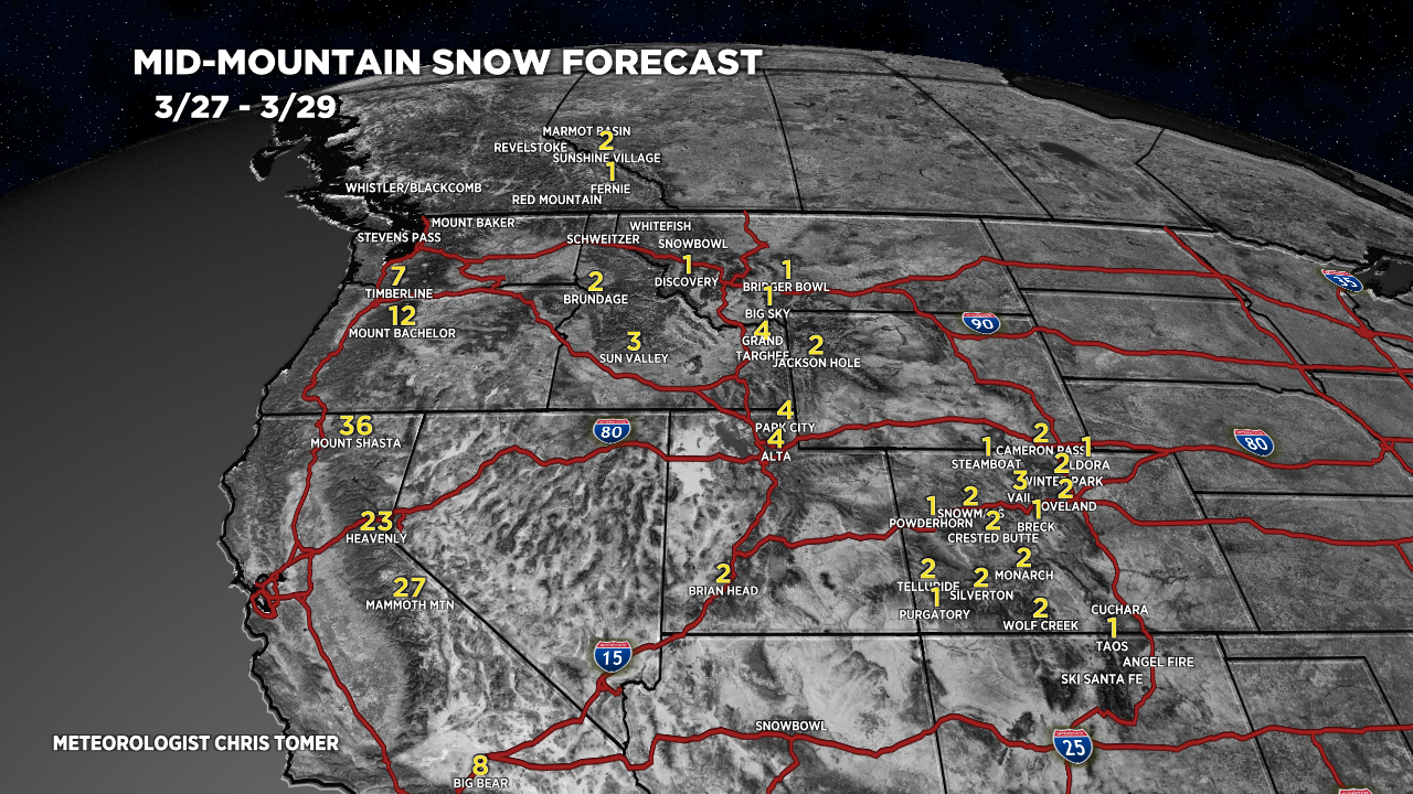
Forecast Totals
3/27-3/29:

3/30-4/5:

3/27-4/5:
VT/NH/ME key snow dates: Late 3/27-3/28 (light), 3/31-4/1 (moderate), 4/5 (moderate).
