Tomer’s Take: I’m forecasting four different storm systems for parts of the West through 4/28.
Forecast Freezing Levels
Wasatch, Maximum height of daily freezing level:
4/18: 7500′
4/19: 6100′
4/20: 6400′
4/21: 8000′
4/22: 9800′
4/23: 10100′
Colorado’s Central Mountain Zone, Maximum height of daily freezing level:
4/18: 11900′
4/19: 8400′
4/20: 6600′
4/21: 8000′
4/22: 10100′
4/23: 11900′
Projected Melt-Out Dates
Bear Lake, RMNP, CO: June 10
Berthoud Pass Summit: June 14
Columbine Pass: June 1
Echo Lake: May 31
High Lonesome: June 15
Independence Pass: May 29
Jones Pass: June 4
Loveland Basin: June 16
Molas Lake: June 5
Rabbit Ears: June 5
Wild Basin: June 6
Forecast Pattern
Forecast jet stream valid 4/27. You can see the final storm system of the cycle 4/27-4/28 sliding through the Intermountain West. Notice the high pressure ridge across the West Coast/PNW.

Forecast Timing
Forecast radar/satellite 4/18-4/23.
Alta, UT
4/18: 6″
4/20: 1″
4/21: 1″
4/22: 1″
4/23: 3″
4/24: 3
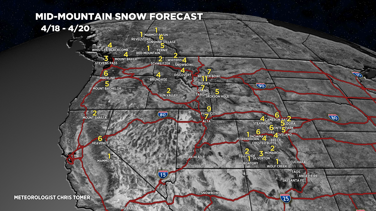
Forecast Totals
4/18-4/20:

4/21-4/27:

I’m curious what you’re using to predict the melt out dates. There’s a handful of us working a the Rocky Mtn Biological Lab in Gothic and there is definitely some excitement for the road to open back up again so we don’t have to ski groceries and laundry in and out. Seems like more snow than last year but maybe melting faster than last year with the dust and warm temps. Curious if you have a melt out date for Gothic townsite? Thanks!
Hi Travis, it’s based a statistical SNOTEL snow-water-equivalent projection. The dates I quote use the 50th percentile. Doesn’t take into account dust. Schofield Pass: 50th percentile melt-out date is June 20. My guess is the dust will accelerate this date.
Chris
Great! Thank you!