Tomer’s Take: 3-4 storm systems are lined-up for the West through 4/28. Brief high pressure may develop April 28-May 1.
Will Alta, UT hit 900″ by May 1? Yes, it appears likely.
Will Aspen Highlands, CO hit 450″ by May 1? 50/50 odds.
Will Jackson Hole, WY hit 600″ by May 1? Yes, it appears likely.
Will Wolf Creek Ski Area, CO hit 500″ by May 1? Yes, it appears likely.
Forecast Freezing Level
Wasatch, Maximum Height. This means, the freezing level rises to a maximum level during daytime heating then could re-freeze overnight.
4/17: 11200′
4/18: 7200′
4/19: 6100′
4/20: 6100′
4/21: 7100′
4/22: 8200′
Colorado’s Central Mountain Zone, Maximum Height:
4/17: 12300′
4/18: 11700′
4/19: 8200′
4/20: 6700′
4/21: 6700′
4/22: 8400′
Forecast Pattern
Forecast jet stream valid 4/26. Notice the dip and area of low pressure sliding through the West.

May 1
If high pressure develops across the Intermountain West then it is brief April 28-May 1. It’s followed by lower atmospheric pressure anomalies in the mid-atmosphere by May 2 building over the West Coast.
Below is forecast mid-atmospheric pressure anomalies valid May 1.

Forecast Timing
Forecast radar/satellite valid 4/17-4/22:
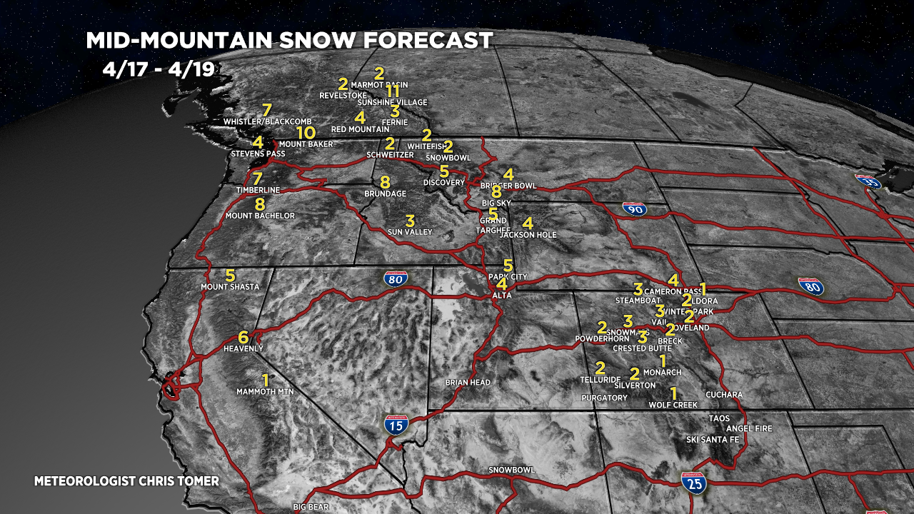
Forecast Totals
4/17-4/19:

4/20-4/26:

You mention freezing levels in the Central Colorado mountains, 4/17: 12300′
Perhaps we are south of Central Colorado, but in Custer County this morning, it was 25* at 8,000 ft.
Thanks, Bill. These are maximum height forecasts. Meaning, during the day the freezing level hits a maximum level of 12300′ and then may re-freeze at night.
Chris
Question: at what point does ‘one’ stop recording snowfall under ‘this’ season? Is it a specific date on the calendar? Is it based on a resort that is still open (Jackson closed but is still recording?) What if it continues to snow up high all summer?
Aspenweather measures from Oct 1 to May 1. Seems like a fair way to do it.
Hi Freddy, I like this policy too. Chris
Hi Krista, I just go to May 1. Chris