Tomer’s Take: The final atmospheric river (AR) surge is underway with big totals across the West. What happens after? A transition occurs with a high pressure ridge building.
My forecast video 1/13:
Current Setup
Infrared satellite shows the Pineapple Express and remaining two areas of low pressure.

Forecast Pattern
Forecast jet stream valid 1/22. Notice the amplitude and high pressure ridging across the West Coast.

Late January
Below is the EPS forecast atmospheric pressure anomalies in the middle of the atmosphere valid late 1/27. This forecast pattern has remained consistent the last few days.
If this occurs, then a drier period is likely for parts of the West.
There is disagreement in this pattern. The GFS/GEFS forecast model(s) doesn’t develop this large ridge. It keeps the PNA negative throughout late January. If that occurs then the pattern remains active for the Intermountain West.
What happens after 1/28? I believe the pattern turns more active for the West in February.

ENSO
La Nina is fading. The next stop is Neutral then data points towards El Nino by Summer and Fall.

Forecast Timing
Forecast radar/satellite valid 1/13-1/18.
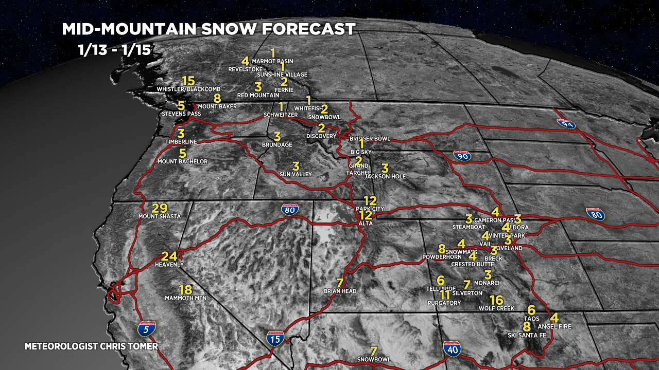
Forecast Totals
Forecast snow totals valid 1/13-1/15.

Forecast snow totals (inches) valid 1/16-1/22.

Forecast snow totals (inches) valid 1/13-1/22. Most of this occurs 1/19-1/20.

I have watched you for years on morning on TV. I think you are the best weatherman i have seen.
I began studying weather in 1956 at age 14. I began flying in 1960, and had a career as an airline pilot. My vocation required some knowledge of weather, my avocation- flying light aircraft – requires a greater knowledge.
I just stumbled upon your blog, and am now a regular subscriber.
Thanks for what you do.
Best of luck.
Neil Kardos
Thanks so much, Neil! Appreciate you subscribing. Chris
Hey Chris,
That La Nina to El Nino transition probability graph caught my eye. Would love to hear some of your analysis in one of your presentations for the move to El Nino represented in that gragh like you did a few months ago for La Nina as we entered Fall to December. I think I heard you say then, or maybe one time before that, the Neutral is when Colorado/Southern Colorado can get more moisture activity. (Hope I represented that correctly.) One question that has come to me is whether the atmospheric rivers we’ve seen lately are precursors to the Neutral or even part of the beginning of it. Another is whether the Neutral is tied to your projection that February looks to be active.
My interest is in mountain climbing going forward into the Summer/Fall.
Thanks, Randy! I’ll put all that into a future post specifically about El Nino/La Nina. The transition to Neutral and eventually El Nino normally generates above normal precip for the Southern Mountains of Colorado. The southern track (Panhandle Hooker storm system) storm system that is currently sliding through is a good example. I’m not sure about the correlation with the atmospheric river. Chris
I hope everything’s alright and that you’re just taking a well-deserved week off of blogging!
Hi Bryon! Are the updates not making it to your inbox? Chris