Tomer’s Take: A major low pressure (last of the atmospheric river) slides through UT/AZ/CO/NM next 24 hours with big totals. Then, the pattern shifts north with high pressure ridging over the Pacific Ocean and West Coast. The jet takes a NW orientation favoring PNW/BC/ID/MT/UT/WY/CO. By February 1, a trough might establish itself across the entire West with snow and cold.
Alta, UT is reporting 20 inches in the last 24 hours. That’s a 4-day total of 49 inches = about a foot a day. 423 inches for the season so far where they’re “Rolling in the Deep”.
Mammoth Mountain is reporting 11 inches in the last 24 hours. 378 inches for the season so far.
Season Totals So Far:

My forecast video 1/17:
Current Setup
Visible satellite shows a split jet with leftover AR moisture and a southern track low. It becomes a Panhandle Hooker storm system for CO/NM.

Forecast Pattern
Forecast jet stream valid 1/25. Notice the high pressure ridging off the West Coast and PNW. This flow favors Banff, MT, WY, northern UT, and the Central and Northern Mountains of CO.

February 1
Below is the EPS forecast atmospheric pressure anomalies (middle atmosphere) for late 1/31.
The high pressure ridge drifts West and a trough develops across the West. This type of pattern supports snow across the West.

Forecast Timing
Forecast radar/satellite valid 1/17-1/22.
Forecast Totals
Forecast snow totals (inches) valid 1/17-1/19.

Forecast snow totals (inches) valid 1/20-1/26. Notice the NW orientation of the snowfall/storm track.

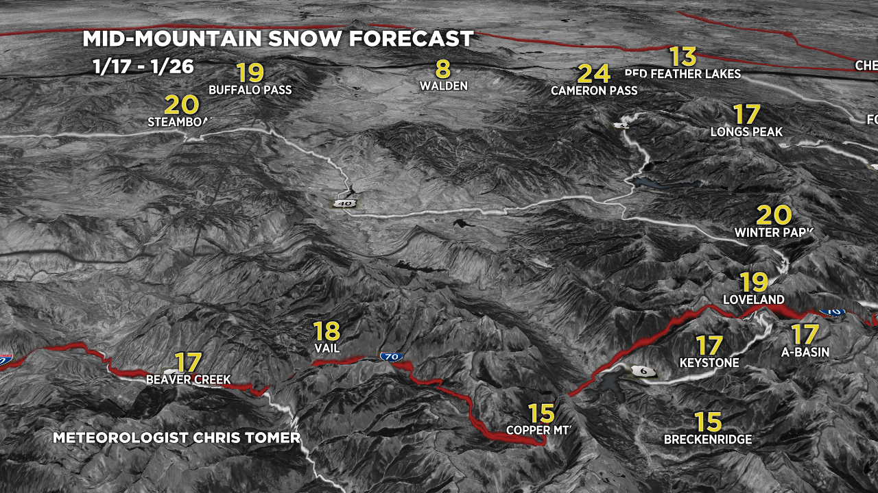
Forecast snow totals (inches) valid 1/17-1/26. Central and Northern Mountains of Colorado:

Forecast snow totals (inches) valid 1/17-1/26. Most of this snow falls 1/19-1/20 and 1/22-1/23.

Yes! The Panhandle Hooker is back!
Yes! Time to bring it back!
The Panhandle Hooker is welcome anytime.
Hi Chris
Since the track for the next few days is more southerly, is it ripe for bringing desert dust, which we have sometimes seen in Colorado especially in late Mar /Apr timeframe and is becoming more common? Or is it too early and the orography is just not suited to bring that phenomenon right now?
Hi Ravi, I think that can happen anytime with these southern track storm systems. I’m not sure this storm had enough low level wind to entrain the dust but we’ll see. Chris
More like 500”+ for mammoth summit.
I saw that too…big summit total!