Tomer’s Take: The storm track favors the PNW/BC/Northern Tier. One storm system drags a cold front with snow through UT, WY, CO, MT 4/12-4/14. Pattern shifts back to the PNW/BC through 4/20.
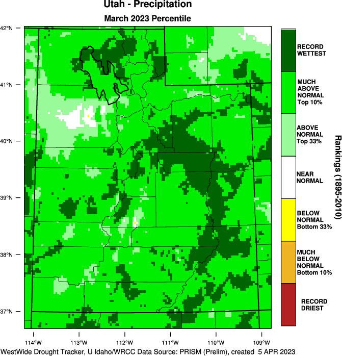
March 2023 Pattern
Looking back, March 2023 was a giant for Utah with record precipitation (dark green).

In Colorado, the trend is clear. The Western Slope received the most precipitation with less east. The Continental Divide truly divided.

Forecast Freezing Level
Wasatch:
4/11: 13100′
4/12: 12100′
4/13: 6400′
4/14: 7500′
4/15: 11000′
4/16: 11900′
Colorado Central Mountain Zone:
4/11: 14400′
4/12: 13600′
4/13: 12100′
4/14: 9000′
Forecast Pattern
Forecast jet stream valid 4/20. A trough of low pressure with rain/snow favors the PNW/BC/Northern Tier.

Forecast Timing
Forecast radar/satellite valid 4/11-4/16.
Forecast Totals
4/11-4/13:

4/14-4/20:

Interesting take:
https://www.latimes.com/california/story/2023-04-11/californias-wild-winter-of-atmospheric-rivers
A meteorologist I follow made this prediction back on October 22, 2022.
https://www.southerncaliforniaweatherforce.com/2022/10/23/breaking-scwf-2022-2023-seasonal-weather-forecast-released-not-a-normal-la-nina/
Thanks, Freddy! He made a good forecast. Especially when you consider how difficult is it to predict atmospheric river events on a seasonal level. Chris
Thanks, David! Good article. I like their graphic showing the 30+ river events. Chris
https://www.latimes.com/california/story/2023-04-11/californias-wild-winter-of-atmospheric-rivers
Well hello and good morning Chris. Just wanted to thank you so much for ordering the prime weather over this week, you couldn’t order anything better since I have family members here for a week, and they are in heaven with the weather. As usual you’re still number one weatherman in our universe. Oh and yes I forgot to mention they love some of your hiking experiences and a couple of those High ones they said you’re crazy! I said that’s why we love him like we do LOL. You have a great and wonderful week, take care of my friend. Bye.
Thanks, John!