Tomer’s Take: Heavy snow is on track for the Northeast 12/16-12/17. Then the pattern shifts back to the PNW/BC/Banff and eventually WY, CO, UT. An Arctic front is the catalyst for shifting the pattern back to the West on/after 12/20.
My forecast video 12/15:
Season Totals so far
I put this together as of 12/15.

Current Setup
Water vapor satellite shows the Western blizzard tracking towards the Northeast. In Pacific, two low pressure systems are meandering waiting to be picked up. An Arctic front appears to pick both storm systems up on/after 12/20.

Northeast Snowstorm
Forecast jet stream valid 12/16. The Western blizzard is riding a powerful jet stream into the Northeast.

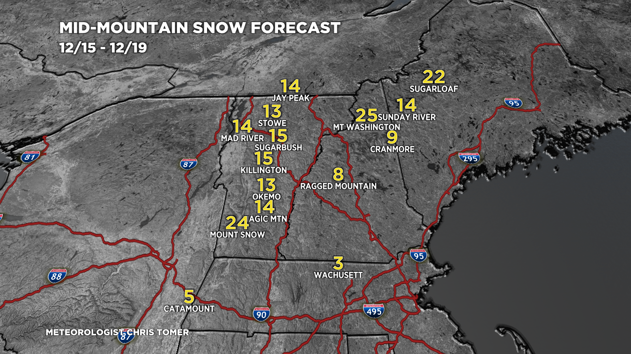
Forecast snow totals (inches) valid 12/15-12/19.

Forecast Pattern
Forecast jet stream valid 12/16. A quiet period for the West except for some light snow accumulation with a fast northerly flow and Clipper.

Forecast jet stream valid 12/24. Big dip in the jet on the East side of the Rockies with Arctic air.

Forecast Timing
Forecast radar/satellite valid 12/15-12/20.
Forecast Totals
Forecast snow totals (inches) valid 12/15-12/17.

Forecast snow totals (inches) valid 12/18-12/23.

Just wanted to thank you for coming back to the blog. All us faithful weather nuts and storm chasers were going through withdrawals not getting a blog post for 3 whole days!
Now see what you can do about sending some of those L’s into CO for the new year. Thank you sir.
Thanks, Randall! Appreciate your loyalty. Are you having a good Fall/Early Winter season? Chris
Other than the Boat, CO is getting hosed from the big storms so far.
Think La Nina Neutral will mean great Jan-Apr dumpage?
Thanks, CW…Steamboat really did well with the last pattern. Aspen/Snowmass also did well and parts of Vail Pass. So far it’s La Nina with a western shift. Looking ahead, I think the pattern continues to favor the Central and Northern Mountains with a slight western shift to include Aspen/Snowmass. Chris