Tomer’s Take: A storm systems tracks through WY/UT and into CO/NM 4/25-4/26. It develops into an ABQ low pressure. This is a wetter storm systems with promise of deep upslope favoring the Front Range, Foothills, Palmer Divide, Colorado Springs, Pikes Peak, Wet Mountains, and Southern Colorado. In the Mountains, this setup favors the Divide-East with less precipitation west of the Divide.
A second fast-moving cold front hits WY and CO 4/27-4/28 with additional snow accumulation.
Forecast Freezing Level
Colorado’s Central Mountain Zone, Daily Max/Min:
4/24: 11200’/8500′
4/25: 10000’/7700′
4/26: 10200’/7000′
4/27: 12000’/9200′
Wasatch, Daily Max/Min:
4/24: 9400’/7200′
4/25: 7700’/5900′
4/26: 11000’/9400′
4/27: 12000’/10300′
Forecast Pattern
Forecast jet stream valid 5/3. Notice the area of low pressure in CA.

Forecast Timing
Forecast radar/satellite valid 4/23-4/28.
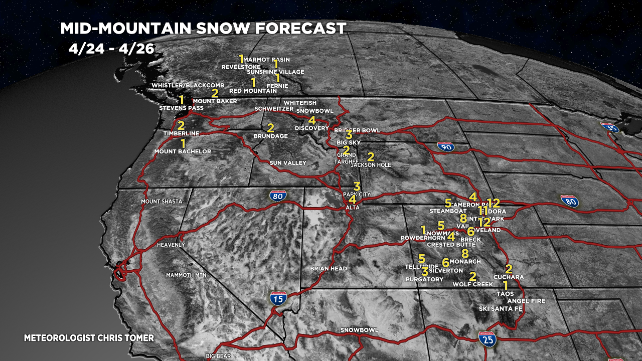
Forecast Totals
4/24-4/26:

4/27-5/3:

Headed to Utah this weekend to ski Mt Tukunikavitz, and trying to infer weather there based on this forecast….any big differences in freezing levels further west?
Hi Robert –
Here’s my forecast for Tuk:
4/28: Dry, sunny, windy, gusts to 55mph, daily freezing level max/min: 11700’/10900′.
4/29: Dry, sunny, less wind, gusts to 20mph, 13500’/11800′.
4/30: Dry, sunny, less wind, gusts to 20mph, 14100’/13100′.
Chris
Love the albuq low (much needed wanted and desired) storms. ‘Q’ you are welcome to bring moisture to CO’s front range. Thank U ❄️⛄️❄️
Thanks, Bonnie!