Tomer’s Take: I’m forecasting four moderate atmospheric river surges through 1/13. Primary beneficiaries are CA, OR, WA, BC. Snow is also likely through the interior Rockies.
My forecast video 1/4:
Current Setup
Visible satellite shows a monster area of low pressure hitting the West Coast with a firehose of moisture. Notice how well-defined the area of low pressure is – the spiral is photogenic.

Forecast Pattern
Forecast jet stream valid 1/13.

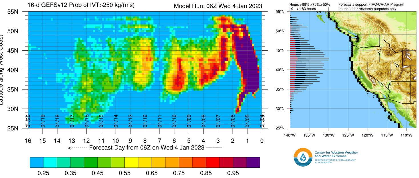
Atmospheric River
Below is the GEFS IVT forecast by latitude out 16 days. The brighter colors (yellow/orange/red) represent larger surges. There are moderate AR surges on 1/4-1/5, 1/7-1/8, 1/9-1/10, and 1/13.

Forecast Timing
Forecast radar/satellite valid 1/4-1/9.
Forecast Totals
Forecast snow totals (inches) valid 1/4-1/6.
By request, I added Eldora, CO to the maps going forward.

Forecast snow totals (inches) valid 1/7-1/13.

Forecast snow totals (inches) valid 1/4-1/13.

Thanks Chris.
You are the best. Have a great 2023.
Thanks! Same to you, happy 2023! Chris
Really enjoy your daily updates, thank you! What are the odds of the jet stream adjusts to send more moisture into the interior of BC?
Hi Dallas, it still looks like the bulk of precip stays in Western BC through 1/14. Thinking moderate accumulation for the interior BC. The jet remains anchored through 1/14 favoring the West Coast.
Thanks Chris, always enjoy reading your posts. You have the format nailed for us snow loving folks! I really appreciate that you include information for the Utah resorts. It’s not necessarily the focus, but usually more than enough info to draw conclusions on what we might get.
Thanks, Randy!
Sounds like warm temps in Cali tho could spell disaster for the snow storm totals at the resorts and cause localized flooding, etc? Doesn’t seem like a good storm to try to chase powder
Hi Brian, snow levels with the 1/4-1/5 storm are abnormally high. Looking down the road, the storm system on 1/9-1/10 will probably push snow levels high again at least initially. I’m still worried about the amount of rainfall the NOCA valleys have yet to receive. We could be looking at another 10-15 inches of rain between 1/6-1/14.
Thankyou for your forecasts!
Any idea how the SW will look for Feb into March?
Hi Judi, best chances for snow in the SW are now through February. Then the pattern features more ridging in the SW in March and April, which could mean drier and warmer.