Tomer’s Take: A powerful atmospheric river remains on track for the West through 1/4. Grand totals of 1-5 feet (or more) for PNW, BC, CA, UT, WY, and CO.
-> See below for my forecast grand totals and snow timeline for the Wasatch.
My forecast video 12/27:
Current Setup
Infrared satellite shows the storm track reaching all the way back to Hawaii. This is the Pineapple Express.

Forecast Pattern
Forecast jet stream valid 12/30 continues to show an impressive west-to-east conveyor belt of moisture slamming into the West like a firehose.

Forecast Timing
Forecast snow totals (inches) valid 12/27-1/1.
Forecast Totals
Forecast snow totals (inches) valid 12/27-12/29.

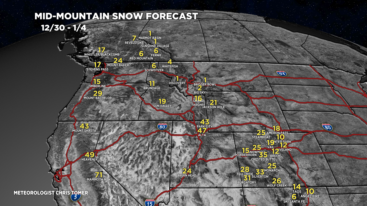
Forecast snow totals (inches) valid 12/30-1/4.

Forecast grand totals 12/27-1/4:
Mammoth Mountain, CA: 99″
Tahoe/Palisades/Kirkwood/Heavenly: 68″
Alta, UT: 70″
Wolf Creek, CO: 53″
Crested Butte, CO: 47″
Aspen/Snowmass, CO: 34″
Jackson Hole, WY: 31″
Snow Timeline for the Wasatch:
- 12/27: 11″
- 12/28: 11″
- 12/29: 1″
- 12/30: 15″
- 12/31: 15″
- 1/1: 10″
- 1/2: 1″
- 1/3: 1″
- 1/4: 4″
Forecast snow totals (inches) valid 12/27-1/4.

Love your forecasts of snow accumulations. I wish you would include Arizona Snowbowl and Sunrise Ski Resort for us desert rats in Phoenix that can travel only 2 or 4 hrs to ski. Thank you!
Thanks, Linda!
I live in Phoenix too, just check OpenSnow. Spoiler alert, we’re getting hardly any as usual and Snowbowl is already completely lying about their advertised forecasts in their recent email alert. Do yourself a favor and take the short drive to Brian’s Head at the very least
I added Snowbowl to my maps, thanks!