Tomer’s Take: Off/on light snow continues today in CO. This storm system then races into the Northeast and delivers moderate to heavy snow accumulation at the ski areas of VT, NH, and ME between PM 11/21-11/22.
What’s next? A strong Canadian cold front dives south through MT, WY, UT, CO, and NM with much colder air and snow accumulation 11/23-11/25.
Snowbird, UT is reporting 21″ in 48 hours.
Loveland, CO picked up about 6″ and it’s still snowing.

Current Setup
Water vapor satellite shows the current departing area of low pressure and what’s next in the north Pacific.
Orange/red = drier air aloft.

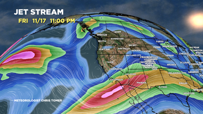
Forecast Jet Stream
Valid 11/24. Canadian cold front moving south through CO into NM. Door is wide open for much colder air for MT, WY, UT, CO, NM.

Valid 11/29. Storm track favors the PNW/BC.

Forecast Radar & Satellite
Forecast Snow Totals
MT Snow: 11/23-11/24
WY Snow: 11/23-11/24
UT Snow: PM 11/23-11/24
CO Snow: PM 11/23-11/24
NM Snow: 11/24-11/25