Tomer’s Take: A large trough of low pressure approaching CA dictates the flow of business across the West through 11/20. Two cold fronts mesh with energy from this trough generating snow for ID, WY, UT, MT, CO, NM. A third storm system tracks across the PNW, ID, MT, UT, WY, CO 11/23-11/24.
My forecast video:
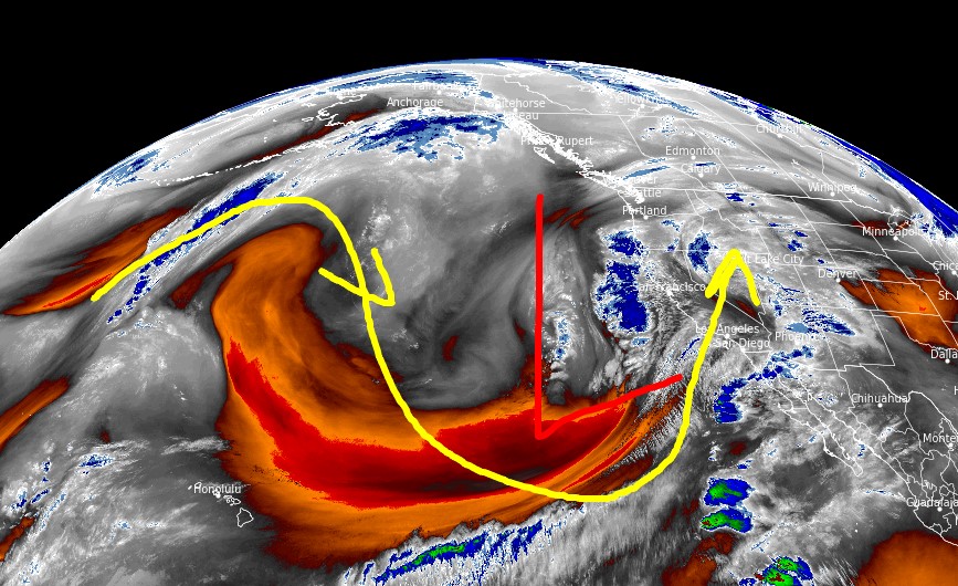
Current Setup
Water vapor satellite shows a large trough of low pressure approaching CA.
Orange/red = drier air aloft.

Forecast Jet Stream
Valid 11/19. Energy slides down from MT, WY, UT, CO, NM.

Valid 11/23. Third storm system delivers light snow to PNW/BC/Banff, ID, MT, UT, WY, CO through 11/24.

Forecast Radar & Satellite
Forecast Snowfall
*Updated 2:30pm 11/15.
Utah Snow: 11/16, 11/18-11/19.
Colorado Snow: 11/16, 11/18-11/20.
Wyoming Snow: 11/16, 11/18-11/19.

*Updated 2:30pm 11/15.

what does the travel along I70 look like on Sunday morning thru evening. I am traveling from north central Kansas to Georgetown? start in the morning around 8 or so and hoping to be home by 4 or 5pm
thanks
My biggest thing is whether or not the snow will move in the eastern plains of Colorado sooner or later on Sunday? Thanks again. the path looks good by watching the video, but I was curious when that low pushes down more on eastern co and western ks
Hi Michael – If you run into precip it’ll be rain from Kansas to Denver. Rain/snow line is Foothills or higher.
perfect thanks. that’s what I wanted to hear. I appreciate it