Tomer’s Take: Data continues to suggest a “strong to extreme” intensity atmospheric river (AR) 12/27-1/4 for most of the West. Grand totals (see below) of 1-5 feet or more.
My forecast video 12/26:
Current Setup
Water vapor satellite shows the organizing atmospheric river reaching all the way into the western Pacific. This is the Pineapple Express.

Forecast Pattern
Forecast jet stream valid 12/30. Very impressive west to east jet stream pattern acting like a conveyor belt for the moisture. The jet reaches west beyond Hawaii.

Forecast Timing
Forecast radar/satellite valid 12/26-12/31.
Forecast Totals
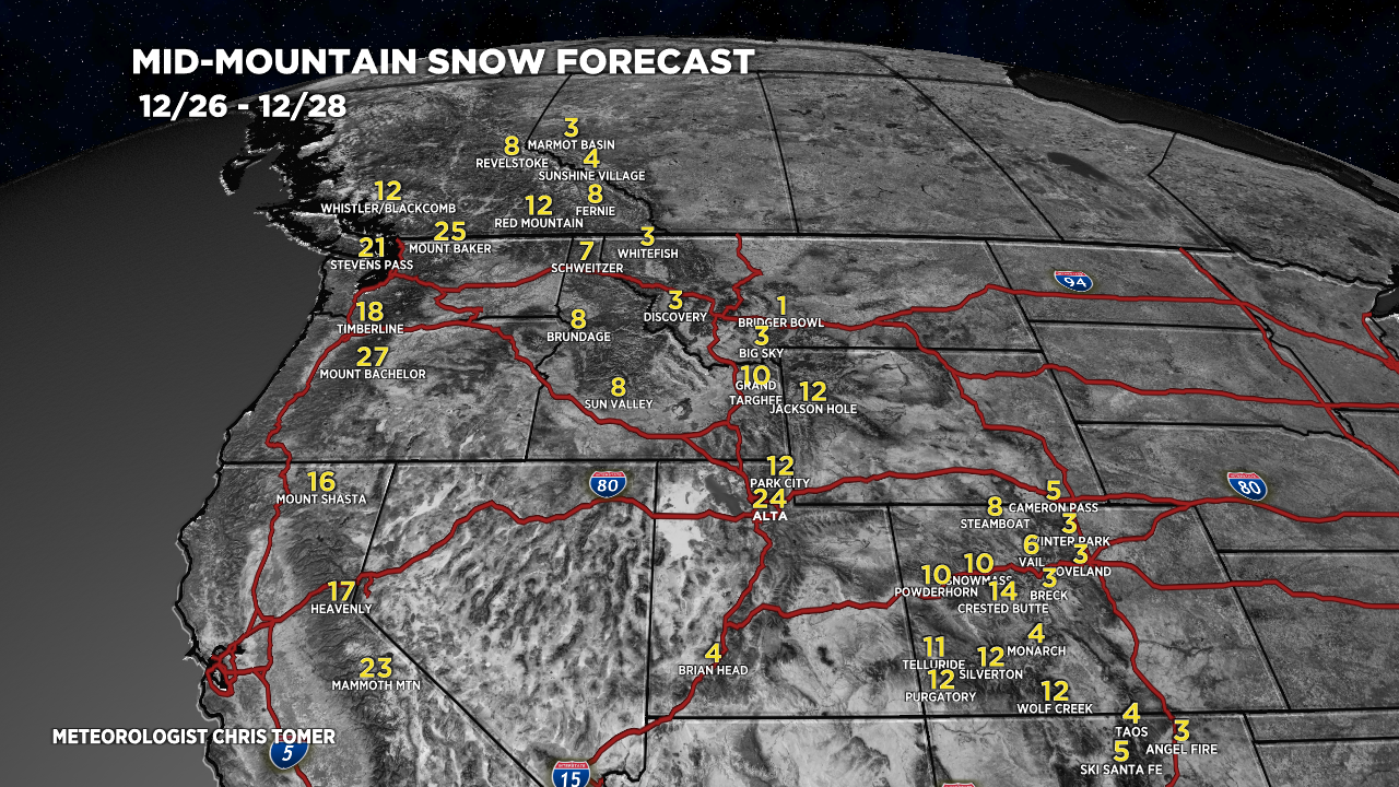
Forecast snow totals (inches) valid 12/26-12/28.

Forecast snow totals (inches) valid 12/29-1/4.

My forecast grand totals 12/27-1/4:
Alta, UT: 64″
Jackson Hole, WY: 29″
Aspen/Snowmass, CO: 32″
Crested Butte, CO: 54″
Silverton, CO: 48″
Wolf Creek, CO: 46″
Mammoth Mountain, CA: 91″
Heavenly/Tahoe/Palisades/Kirkwood: 71″
++++++++++++++++++++++++++++++++++++++++++++
Key Snow Timeline for Wasatch:
- 12/27: (PM) 14″
- 12/28: (AM) 10″
- 12/29: (PM) 2″
- 12/30: 12″
- 12/31: 12″
- 1/1: 12″
- 1/2: 1″
- 1/3: 1″
- 1/4: 1″
Forecast snow totals (inches) valid 12/26-1/4.

Good stuff! May the Pineapple Express activate and provide the west with plenty of moisture.
You know it, Scott! Merry Christmas to you and family. Chris
great numbers!