Tomer’s Take: 21-30 inch Sierra totals so far with snow continuing. Next stop is ID, WY, MT, UT, and CO for big totals through 12/15. Then pattern turns more tranquil after 12/15. Active pattern shifts to the Northeast.
Current Setup
Water vapor satellite shows the big low moving at snails pace through CA. Red/orange = drier air aloft.

Forecast Pattern
Forecast jet stream valid 12/12/2022. The slow movement of the low through the trough generates three days worth of snow accumulation and wraparound snow in parts of MT, WY, and C+N zones of CO.

Forecast jet stream valid 12/13/2022.

Forecast jet stream valid 12/20/2022. The pattern is much quieter across the West with only a fast-moving low on the northern branch with light accumulation.

Forecast Timing
Forecast radar/satellite valid 12/11-12/16.
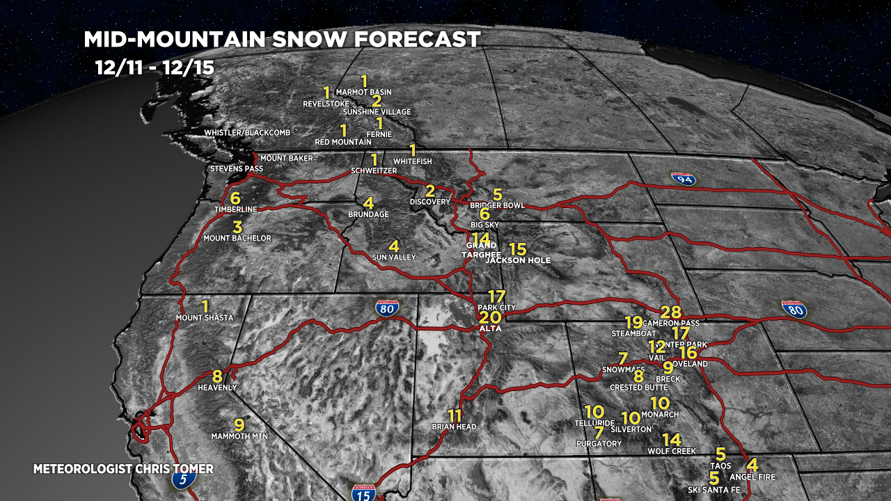
Forecast Totals
Forecast snow totals (inches) valid 12/11-12/15.

Forecast snow totals (inches) valid 12/16-12/19.

Forecast snow totals (inches) valid 12/12-12/19. Most of this snow accumulation occurs with a larger storm system on 12/16-12/17.

My forecast video 12/11:
Great to see big snow totals in the mountains. Any thoughts on Denver area snow totals for next 2-4 days?
Thanks, Patricia! Thinking 1-4 inches in Denver Metro by Tuesday night. Bigger impact is up the I-76 Corridor in Northeast Colorado with 4-12″ + 30-50mph wind gusts. Chris
Here we go. Maybe a white Christmas ?
Hi Judi, in Denver the odds at this point are low for snow falling on Christmas. Chris
Hey Chris Tomer! It’s snowing here in Grand Junction. 🙂 Just a humble request to add Powderhorn to your snow totals map…
Thanks, Ashley! Chris
Love your posts. Haven’t gotten any since Saturday or Sunday
Hello
Need my Vermont update!!
Much Thanks Chris!!