Tomer’s Take:
- Pattern change underway. High pressure becomes dislodged.
- Two low pressure systems lined-up: 10/22-10/24 and 10/26-10/28.
- Bullseyes: Utah’s Wasatch especially Little Cottonwood, Colorado’s Western/Southwest mountains including Crested Butte, Purgatory, Silverton and Wolf Creek, Montana’s Big Sky and Bridger Bowl.
Current Setup
The long-standing high pressure ridge becomes dislodged and replaced by both low pressure systems 10/22-10/28.
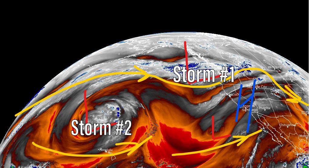
Water vapor satellite shows the setup. Storm #2 is currently cut-off but will eventually be reabsorbed by the Polar Jet. Orange/red = drier air aloft.
What is a cut-off low? It’s simply not attached to the main jet stream flow. It’s spinning alone.

Storm #2 Pattern
Forecast mid-atmosphere pressure anomalies show the potential for a second trough 10/26-10/28.

Forecast Wind Gusts
| Grand Teton | MPH |
| 10/21 | 55 |
| 10/22 | 55 |
| 10/23 | 35 |
| 10/24 | 40 |
| Kings Peak | MPH |
| 10/21 | 35 |
| 10/22 | 65 |
| 10/23 | 45 |
| 10/24 | 30 |

Forecast Snow
Forecast radar/satellite valid 9pm Saturday 10/22.

Forecast radar/satellite valid 6am Sunday 10/23.

Forecast radar/satellite valid 9pm Sunday 10/23.

Forecast snow totals between 10/21-10/24.

Forecast snow totals between 10/26-10/28.

My forecast video:
Thanks for keeping those Alta numbers low!
Thanks, JC! This was a good one for Alta. Chris