Tomer’s Take:
- Rare triple-dip La Nina.
- Multivariate ENSO Index strongest since 2010.
- Warm blob is back but for how long?
- Abnormally warm and dry Fall season across the West.
- Late start to Winter.
- Large Western ridge of high pressure September 2022 – March 2023.
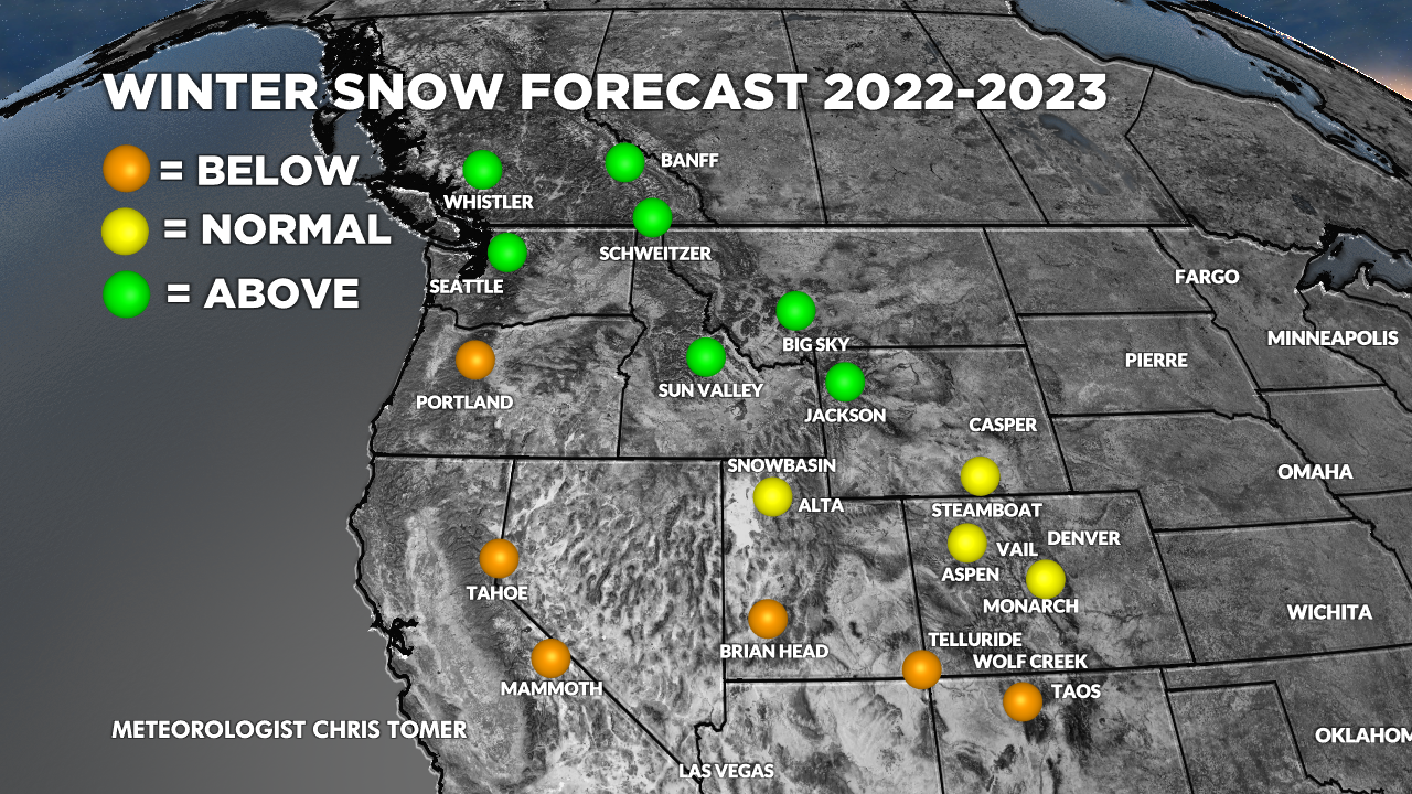
- Overall, target PNW, British Columbia, Banff Area, Wyoming, Idaho, and Montana for most consistent winter snowfall.
- Two big unknowns: Warm SST’s North Pacific and underestimation of La Nina strength this Fall and early Winter. Both could complicate the Winter storm track and snowfall pattern(s).
Winter Forecast Video
Video contains my entire forecast.
Triple-dip La Nina
What is La Nina? Colder than normal (-0.5C or colder) sea surface temperatures in the Equatorial South Pacific (see graphic below). El Nino is the opposite (+0.5C or warmer). Both anomalies have global implications on weather and climate.
Currently, sea surface temperatures near the equator are running colder than normal for the third straight year. Triple-dip La Nina’s are rare only occurring three times in the last 73 years.

Here’s the global sea surface temperature anomalies valid 8/29/2022. Red/orange = above normal. Blue = below normal.
Notice the sea surface heat wave in the North Pacific and North Atlantic.

The Multivariate ENSO Index (MEI) factors in five different variables and assigns a value. It’s currently the strongest (coldest, negative) value since 2010. It says this dip is the strongest of the three dips so far.

Strongest triple-dip La Nina since 2010:

Warm Blob
Sea surface temperatures are abnormally warm in the North Pacific (off the PNW/B.C. coast and California coast). This directly affects the storm track and precipitation patterns. Will this continue all winter?

- This is where important uncertainty remains in the forecast.
- I believe the water off the PNW coast stays abnormally warm through November then cools-off in December. Some forecast data suggest this water does not cool-off and the PNW stays abnormally dry.
- The result: warm and dry across most of the Intermountain West through November then snowier/colder weather settles in December-March.
- I believe the water off the California coast stays abnormally warm the entire winter. The result: warmer and drier than normal winter.
Warm and Dry Fall Season
Most of the Intermountain West is in for an abnormally warm and dry September, October, and November. It will mirror the last few years with a large Western ridge of high pressure.
Said another way, it’ll be a late start to winter.
The most consistent snow and cold temps arrive in December as the jet stream finally dips south.
Forecast
I agree with the official NOAA ENSO forecast, which maintains high chances for La Nina through Fall (blue bars) then it fades in January 2023 to Neutral phase (gray bars).
Important note: It’s possible some forecast data is underestimating the strength of La Nina this Fall and early Winter.

The latest ensemble forecast spread from the Climate Forecast System shows a strong Fall La Nina that fades early 2023.

My big picture pattern forecast. Notice the large Western ridge of high pressure.

All other forecast specifics are in the Winter Forecast Video at the top of this page.
I would have thought warmer water in the North Pacific would create higher precipitation but I am thinking how the Caribbean works where warm water helps strengthen storms.
Thanks, Randy!