Tomer’s Take: The Intermountain West enters a quiet period 2/1-2/4 (ssshhhh) with high pressure. Then a storm system flattens the ridge on/after 2/5 with snow returning. The hot spot during the quiet period is the PNW/BC. Mount Baker could see over 4 feet.
Current Setup
Water vapor satellite shows the current setup. Orange/red = drier air aloft. The Pacific is busy but the storm track will take them into the BC/PNW until 2/5.

Forecast Pattern
Forecast jet stream valid 2/9. The next trough of low pressure nails the PNW/BC.

Forecast Timing
Forecast radar/satellite valid 1/31-2/5.
Mount Baker
A slug of moisture hits Baker 2/3-2/9 and the forecast totals have exploded.
Forecast totals:
2/3: 12″
2/4: 20″
2/5: 20″
2/6: 10″
2/7: 3″
2/8: 20″
Forecast Totals
Forecast snow totals (inches) valid 1/31-2/2.

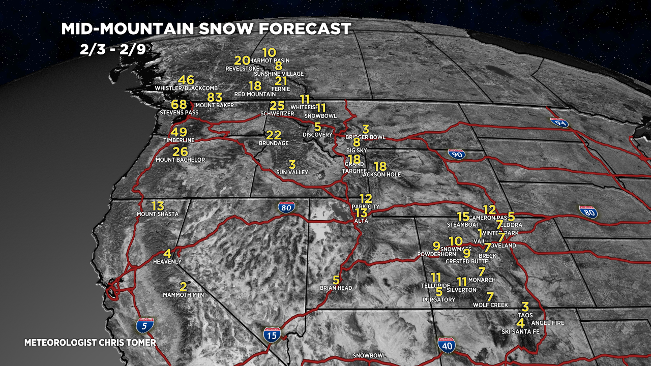
Forecast snow totals (inches) valid 2/3-2/9.
Teton snow timeline:
2/5: 10″
2/6: 2″
2/7: 2″
2/8: 2″
2/9: 10″+

Forecast snow totals (inches) valid 1/31-2/9.

No love for vail? 🙁 hopefully that’s a computer anomaly.
😉 That should read, “10”
Chris
Hi Chris
I appreciate all your hard work and
Expertise!
I’m looking for a small weather station that I can put my house in Midway Utah, so I know what’s going on in my local area. Any suggestions of mini weather stations?
Thanks !
Brian
Thanks, Brian!
Ambient Weather a nice modern lineup of personal weather stations. Many are compatible with your smartphone.
https://ambientweather.com/
Chris