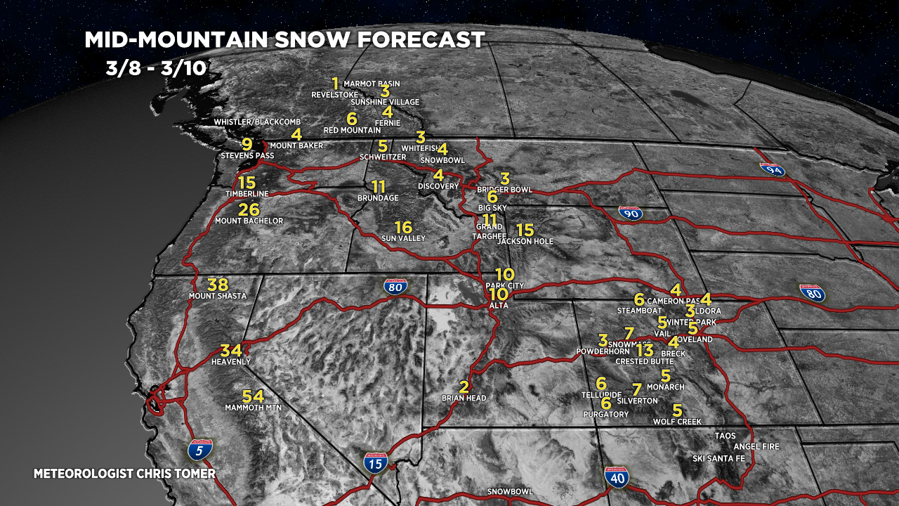
Tomer’s Take: Big snow totals are likely through 3/17 with two different moderate to strong intensity atmospheric river surges. The Northeast gets a coastal storm system with heavy snow accumulation 3/13-3/15.
Season Totals So Far:

My Forecast: High chance that Palisades Tahoe overtakes Alta and Brighton by 3/18.
Current Setup
Water vapor satellite shows an organizing Atmospheric River pattern.

Forecast Pattern
Forecast jet stream valid 3/11. Notice the west to east orientation. This is the Pineapple Express with moisture transport from Hawaii to California.

Palisades Tahoe
3/8: 4″
3/9: Late 8″
3/10: 24″+
3/11: 12″
3/12: 6″
3/13: 20″+
3/14: 6-8″
3/15: 12″
3/17: 4″
Forecast Totals
3/8-3/10:

3/11-3/17:

3/8-3/17:

3/8-3/17:

3/8-3/17:
VT/NH/ME Key Snow Dates:
3/13: Late 6″
3/14: 10-12″+
3/15: 1-2″


thanks, busy year!
Yes sir!
This is my main weather site for snow updates! I thought Mammoth had more snow? Are they using the summit or mid-station and what do other resorts use?
Hi Kim, Mammoth uses a base measurement and summit measurement but no mid-mountain. Chris
I love your blog, I tell everyone to use it! One question, how does Alta have 4’ more than snowbird?
Thanks, Nathaniel…a good question for Snowbird and Alta. Chris
After looking at the snowfall totals to date I am starting a Snow Justice movement for resorts with less than 220 inches of snowfall to date.
In a winter with such abundant snowfall no resort should have to suffer with less than 220 inches of snowfall. It’s not fair!
I demand Snow Equality for All Resorts!!
LOL, thanks Grog.
Do you think Jackson will get too warm during this upcoming Friday to ski well?
Hi Joe, I think the top of Rendezvous doesn’t exceed 20F on Friday. Bottom will be warmer of course.