Tomer’s Take: Snow continues in the Southern Rockies with an Arctic Front then a quiet period emerges 2/1-2/4 for the Interior Rockies. A storm system will follow on 2/5-2/8 with over a foot for the Tetons and Wasatch. The place to be during the quiet period is the PNW/BC.
Follow-up from 1/29 —>
On my forecast video yesterday, I randomly caught a Steamboat Ski Patroller on-cam digging out their Snow Stake buried in about 6 feet of snow. Link to the video is right here….take a look, it’s epic!
The Patroller emailed me and his name is Jon Nesbitt. Thanks for reaching out to me, Jon!

Steamboat is reporting 44″ in the last 6-7 days and 308″ for the season so far.
Snow history:
1/25: 6″
1/26: 5″
1/27: 7″
1/28: 10″
1/29: 10″
1/30: 6:
Buffalo Pass (just north of Steamboat) is reporting 4.7″ of SWE (snow water equivalent). That’s roughly 66 inches of snow in the last 6-7 days.
My forecast video 1/30:
Current Setup

Forecast Pattern
Forecast jet stream valid 2/7. Notice the big trough swinging through the Rockies. This supports a storm system 2/6-2/8.

Forecast jet stream valid 2/8.

Forecast Timing
Forecast radar/satellite valid 1/30-2/4.
Mount Baker
2/3: 12″
2/4: 6″
2/5: 3″
2/6: 10″
Forecast Totals
Forecast snow totals (inches) valid 1/30-2/1.

Forecast snow totals (inches) valid 2/2-2/8.
Teton Snow Timeline:
2/4: 3″
2/5: 3″
2/6: 2″
2/7: 8″

Forecast C+N CO snow totals (inches) valid 1/30-2/8.
Snow Timeline for Loveland:
1/30: 4″
1/31: 1″
2/6: 1-2″
2/7: 1-2″
2/8: 1-2″

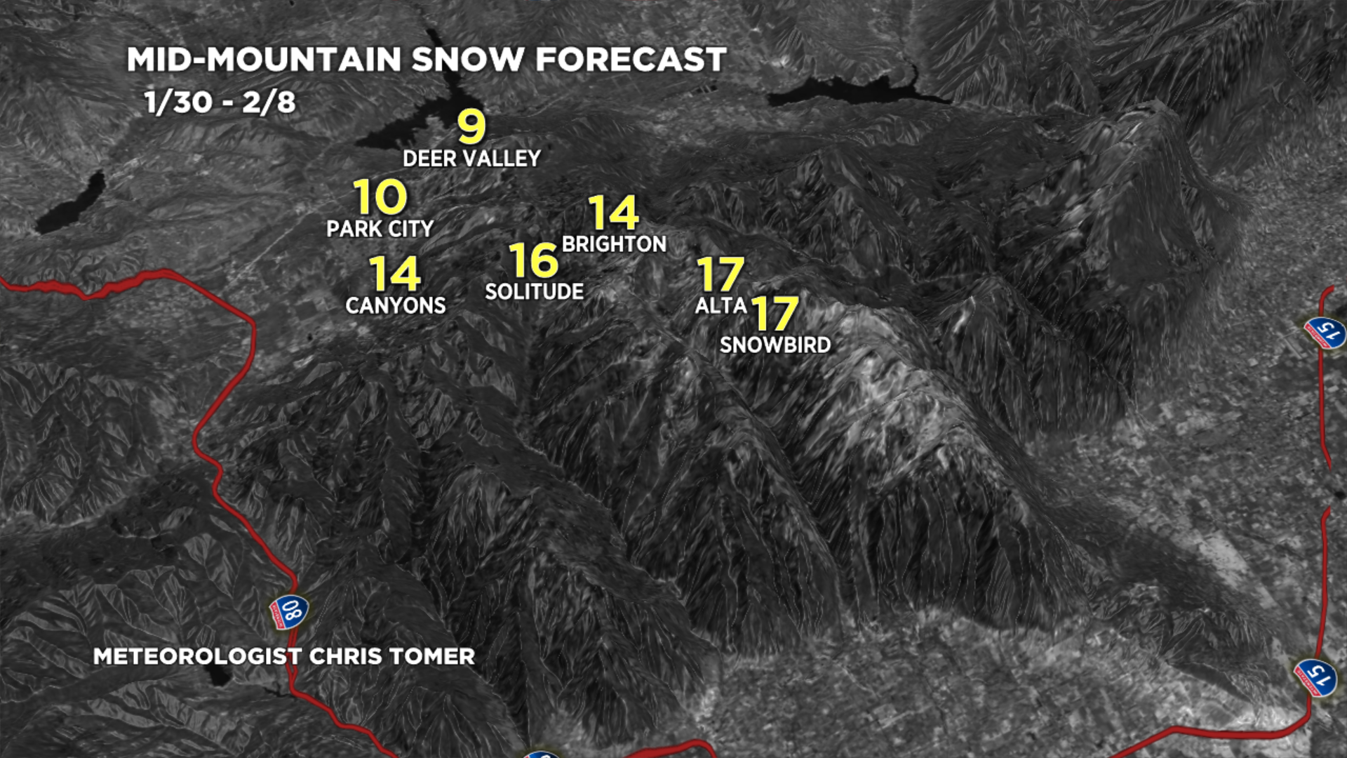
Forecast Wasatch snow totals (inches) valid 1/30-2/8.
Snow Timeline:
2/4: 2″
2/5: 7″
2/6: 4″
2/7: 3″
2/8: 1″

Forecast snow totals (inches) valid 1/30-2/8.

General question: how do they do the snow measurements listed as the summit of mountains such as Longs Peak? I have never seen any equipment on the summit, but may have missed it.
Hi Dan, unless it’s a human measurement or Snotel then it’s an estimate based on nearby readings.