Tomer’s Take: The main storm system of the period occurs 2/13-2/15 with colder air and big totals. A storm on it’s heels 2/19-2/20 is supported by both the southern and northern jet branches.
My video forecast update 2/11:
Current Setup
Water vapor satellite shows a busy Pacific with both the northern and southern jets active.

Forecast Pattern
Forecast jet stream valid 2/19. Notice the big trough and dip in the powerful jet with northern and southern branch involvement.

Forecast Timing
Forecast radar/satellite valid 2/11-2/16.
Wolf Creek
2/13: 8″
2/14: 20″
2/15: 20″
2/16: 2″
Taos
2/13: 3″
2/14: 7″
2/15: 12″
2/16: 1″
Forecast Totals
Forecast snow totals (inches) valid 2/11-2/13.

Forecast snow totals (inches) valid 2/14-2/20.

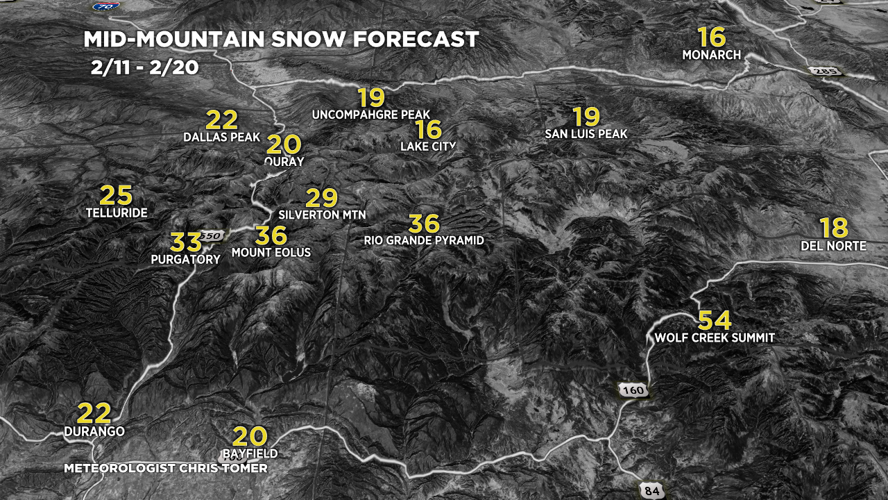
Forecast snow totals (inches) valid 2/11-2/20.
Southern Colorado Grand Totals:

Forecast snow totals (inches) valid 2/11-2/20.


Chris, When climatologists study peak snowpack and calculate how much snowmelt will ultimately flow into downstream reservoirs (factoring in SWE, melt time, absorption by soils, ect.), how much do they account for sublimation? I am talking about high mtn areas near Crested Butte.
I also am wondering if you could give me the simple version of what are the conditions for snow sublimating instead of melting. And, can snow sublimate in the Spring when melting is also occuring?
Thanks for any comments or research you can direct me to!
Colleen
Hi Colleen! Thanks for reaching out.
This is not my area of expertise but I’ve been on a few different field SNOTEL measurements with NRCS hydrologists. When sublimation occurs (and it occurs all the time) the density of the snow automatically changes and this in turn changes the SWE. Send an email to Dr. Mckenzie Skiles. She has the answers your’re looking for – this is her specialty: https://faculty.utah.edu/u0458147-S._McKenzie_Skiles/research/index.hml
Chris
Love your site!
Thanks, Randy!