Tomer’s Take: A dip in the jet stream, trough of low pressure, and small surge of Monsoonal moisture hits the Intermountain West between 9/1-9/4 then the pattern dries out. Who’s included? AZ, UT, NV, CO, WY, ID, MT. Precipitation will include rain, snow, and thunderstorms.
Storm System
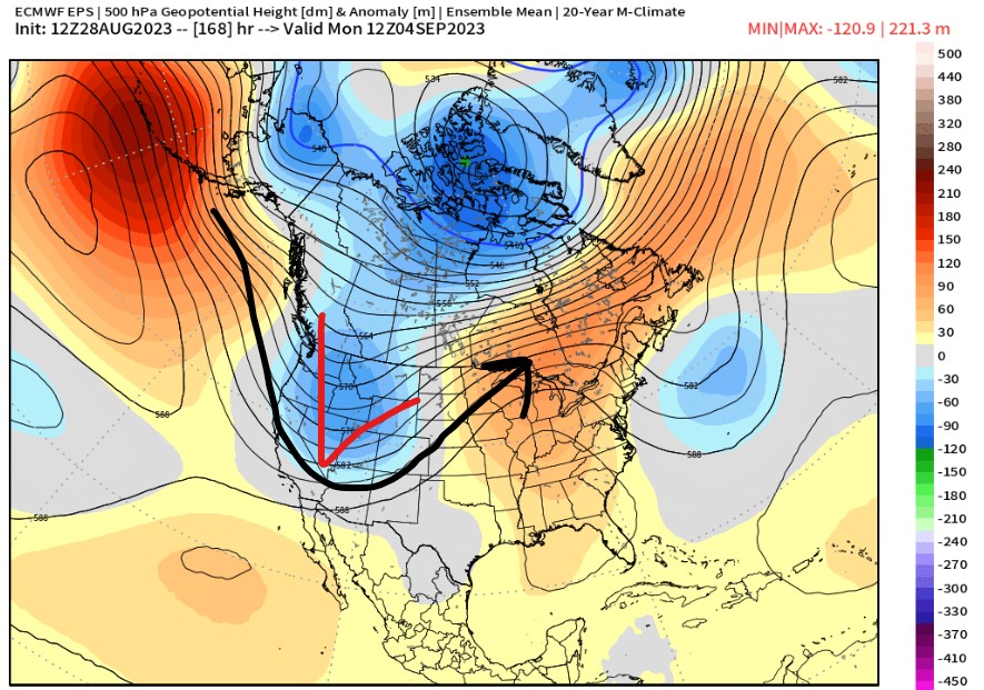
Below is forecast jet stream level valid 9/2-9/3. Notice the dip in the jet stream over the West. This coddles a storm system, gathers moisture, and then moves across the Intermountain West.

Below is forecast mid-atmosphere pressure anomalies. The trough and area of low pressure are well-defined and sets the precipitation wheels in motion.

Precipitation
Below is forecast 24-hour precipitation valid 9/2. You can see the two sources of moisture. One with the storm system and the other from the Monsoon source region. Areas impacted include northern CA, OR, UT, ID, WY, ID, CO, AZ.

Below is forecast precipitation valid 9/4, Labor Day. The bulk of rain/snow/thunderstorms are associated with the storm system by this point in time. Areas impacted include UT, ID, WY, MT, CO and the PNW.

Specifics
Gannett Peak, WY
9/2: 50% PM rain/snow/thunderstorms.
9/3: 20% AM rain/snow, 70% PM rain/snow/thunderstorms.
9/4: 80% AM rain/snow, PM 80% rain/snow.
9/5: AM 20% rain/snow, PM drier.
Granite Peak, MT
9/2: 30% PM rain/snow/thunderstorms.
9/3: 40% AM rain/snow, PM 50% rain/snow/thunderstorms.
9/4: 80% AM rain/snow, PM 80% rain/snow.
Chicago Basin 14ers, CO
9/2: 20% AM rain/snow/thunderstorms, PM 60% rain/snow/thunderstorms.
9/3: 30% AM rain/snow/thunderstorms, PM 100% rain/snow/thunderstorms.
9/4: 50% AM rain/snow, 40% PM rain/snow.
Kings Peak, UT
9/2: 50% AM rain/snow, PM 80% rain/snow/thunderstorms.
9/3: 50% AM rain/snow, PM 100% rain/snow/thunderstorms.
9/4: 50% AM rain/snow, PM 20% rain/snow.