Tomer’s Take: The final storm system loaded with atmospheric river (AR) moisture is moving through CA. It’s a southern track low headed for AZ, NM, UT, and CO with moderate to heavy snow accumulation. What happens after this? Higher atmospheric pressures build across the Pacific/West Coast pushing the jet stream north where it favors the PNW, BC, ID, MT, Banff, WY, UT, and CO via a northwest flow type orientation.
Alta, UT is reporting another 15 inches in the last 24 hours. That’s 399 inches for the season so far. I’m forecasting another 11″ in the next 48 hours.
My forecast video 1/16:
Current Setup
Water vapor satellite shows the final area of low pressure and Pineapple Express.

Forecast Pattern
Forecast jet stream valid 1/25. Notice the high pressure ridging over the Pacific and NW orientation to the flow out of the PNW.

Late January/Early February
The EPS forecast atmospheric pressure anomalies (in the middle of the atmosphere) by late January 30 show the high pressure ridging gone and lower anomalies across the West. This would translate into a stormy pattern for the West by early February.

Forecast Timing
Forecast radar/satellite valid 1/16-1/21.
Forecast Totals
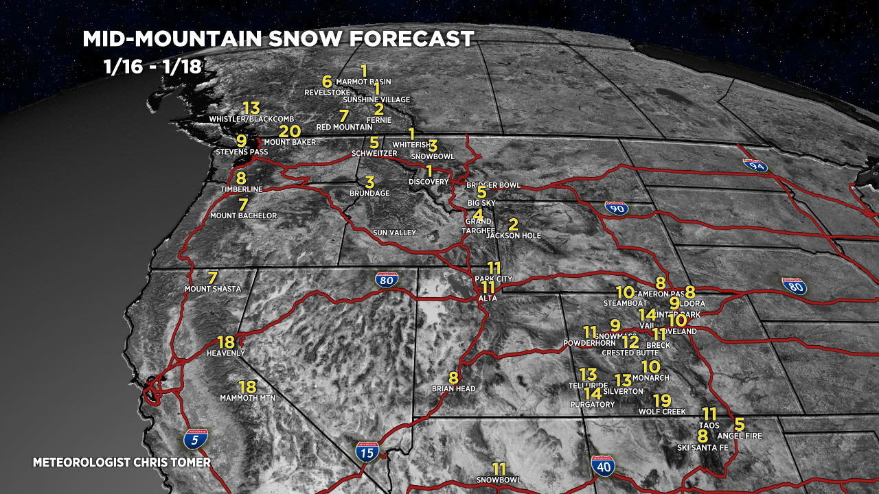
Forecast snow totals (inches) valid 1/16-1/18. This is the final AR period.

Forecast snow totals (inches) valid 1/19-1/25.

Forecast snow totals (inches) valid 1/16-1/25.


So good to see another great winter in Colorado.
All these atmospheric Rivers must not be hitting Colorado as that directly as they can.
It’s still not stacking up like it did in 2017.
Crested Butte sure is looking good though.
Hi Rob! It is good to see. Yes, the current AR is not quite as direct as 2017. The current southern track storm system should deliver another 9 inches to CB. Then the pattern shifts and the activity hits us via NW oriented jet through the end of January. Chris