Tomer’s Take: The next storm system for the Northeast arrives on/around 12/23 but might be too warm with rain initially then snow.
>Out West, an Arctic front 12/20-12/22 spreads snow north to south through ID, UT, MT, WY, CO.
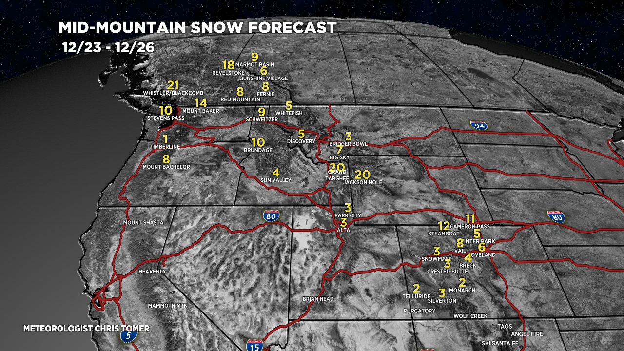
>Then a NW type flow develops 12/23-12/26 favoring WY, ID, MT, CO, PNW, BC, Banff.
- Killington is reporting 22″ in 24 hours.
- Sunday River is reporting 22″ in 24 hours.
My forecast video 12/17:
Current Setup
Water vapor satellite shows a quiet period for the West. It turns more active on/after 12/20 with an Arctic front.
Orange/red = drier air aloft.

Forecast Pattern
Forecast jet stream valid 12/17/2022. A quiet period for the West.

Forecast jet stream valid 12/25/2022. A NW type flow develops 12/23-12/26 favoring PNW, BC, Banff, MT, ID, WY, CO.

Forecast Timing
Forecast radar/satellite valid 12/17-12/22.
Forecast Totals
Forecast snow totals (inches) valid 12/17-12/19.

Forecast snow totals (inches) valid 12/20-12/22. An Arctic front drags snow north to south.

Forecast snow totals (inches) valid 12/23-12/26. A NW flow develops forcing snow through PNW, BC, Banff, ID, MT, WY, CO.

Forecast snow totals (inches) valid 12/17-12/22. Most of this accumulation occurs as residual snow from the big snowstorm 12/16-12/17. Lake effect is also likely 12/18-12/19.

Forecast snow totals (inches) valid 12/23-12/26. A large storm system hits on/around 12/23, but it might be too warm with rain initially then snow.


Hi Chris, love the addition of the east coast forecast, now living in Colorado for the last 10 years still fun to see what’s happening there.
Thanks, Jason! Chris
thank you and have a great holiday!
Thanks, Judi, same to you! Chris