Tomer’s Take: A major atmospheric river (AR) pattern hits the West with big snow totals 12/27-1/3 with 4-5 distinct waves of moisture. A larger storm system hits the Northeast on 1/1 but it appears to be mainly rain.
My forecast video 12/25:
Current Setup
Infrared satellite shows the organizing atmospheric river over the Pacific. Areas of low pressure are lined-up to deliver the moisture.

Atmospheric River Intensity
Data suggest a prolonged AR with intensity pegged early at strong to extreme on 12/27. The moisture feed lasts through 1/3.

Forecast Pattern
Forecast jet stream valid 12/30 illustrates the reach and fetch of this AR. This is the Pineapple Express.

Forecast Timing
Forecast radar/satellite valid 12/25-12/30.
Forecast Totals
Forecast snow totals (inches) valid 12/25-12/27.

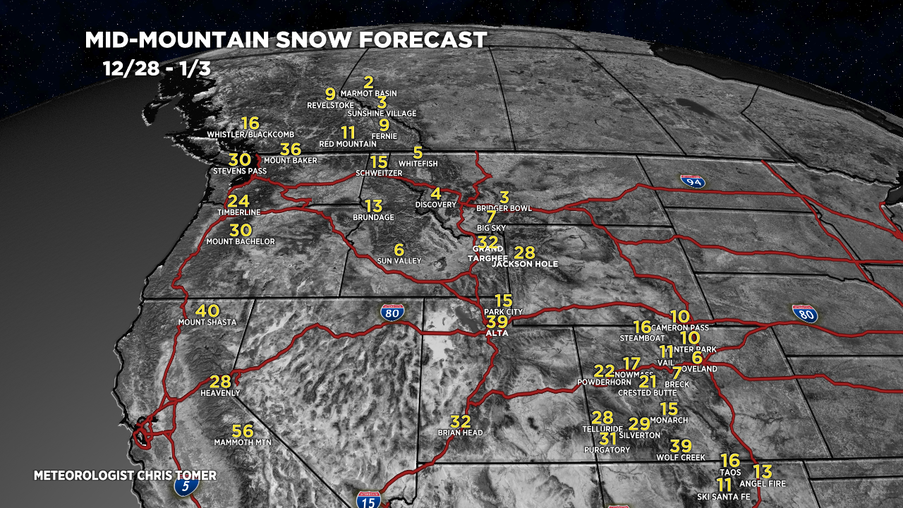
Forecast snow totals (inches) valid 12/28-1/3.

Key snow timeline for the Wasatch:
- 12/27: 6-12″
- 12/28: 6-12″
- 12/29: 6″
- 12/30: 6″
- 12/31: 4″
Forecast snow totals (inches) valid 12/25-1/3.


Was hoping for a U-tube Christmas update with you in a Santa hat while holding a Pineapple in your lap!
How we looking after the 3rd until the 13th? More P-Ex-Spress? Thanks and M.C. & a snowy new year!
LOL maybe next year, Randall!
Merry Christmas Chris! Hope you are having a wonderful Christmas morning. Do you know if any of this snow will drop along the I25 corridor or only in the mountains?
Hi Randy –
Most of the snow will stay in the Mountains but there is one exception on Wednesday night into Thursday morning when 1-3 inches is possible across I-25. Chris
Love to hear it, thank you Chris. I’ve been following your YouTube channel for the last few years along with a few other locals here in UT. You nail it, we appreciate all you do. Enjoy the holidays and fingers crossed for a good preforming storm.
Thanks, Cam! Appreciate the feedback and you guys watching all these years. This looks to be a big one for the Wasatch 12/27-1/4. 50″+ grand totals. Chris